• facebook
  • Twitter
  • Linkedin
  • Youtube
  • Linkedin Group
  • Post a Job
  • Post an Ad
  • Post an Event
  • Post a Directory Listing
  • Post a Press Release
  • Media Kit
  • My Account
  • Login
GoGeomatics
  • MAGAZINE
    • BIM & GIS
    • Community
    • Conference news
    • Earth Observation
    • Education & Careers
    • GEOAI
    • Announcements
    • Reality Capture & Lidar
    • Science
    • Technology
  • Directories
    • ASSOCIATION
    • INDUSTRY
    • EDUCATION
    • Open Data
  • EVENTS
    • GeoIgnite Events
    • Events Calendar
    • GoGeomatics Meetups
  • Services
    • Advertising
    • Marketing
    • Post a Job
    • Post an Ad
    • Post an Event
    • Post a Press Release
    • Post a Directory Listing
    • Media Kit
    • Web Design
  • Find a Job
  • Volunteer
    • Start a GoGeomatics Group
    • Editors & Writers Group
  • About Us
    • About Us
    • Contact Us
    • Frequently Asked Questions
  • Videos
HomeHistory

History

|||||
Education & Careers

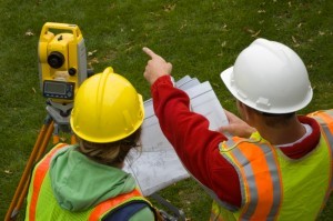
The Art of Being a Cadastral Surveyor: Key abilities every surveyor needs

16 November 2016 Manminder 'Meena' Kaur | 3D

The Art of Being a Cadastral Surveyor:  The key abilities every surveyor needs There is an art to being a land surveyor.  Surveyors take extremely accurate measurements with sophisticated tools to create plans that become legal […]

||
Education & Careers

What are the Top Programming Languages in the GIS World?

16 November 2016 Florin-Daniel Cioloboc | 2016

Image source: www.tiobe.com Every now and again we hear about the importance of programming for Geographic Information Systems(GIS) professionals, that is quickly becoming a key in the evolution of one’s career. It is argued that […]

|||||||||
Technology

QGIS & WorldClim: Using Zonal Statistics to Map Temperature Patterns

31 October 2016 GIS Program Langara CS | Alaska

There has never been a time in the history of GIS when so much free, high quality data has been available. As an example, the WorldClim site (http://www.worldclim.org/) offers temperature raster data, on a global […]

||||||
Community

Canadian Cartography: GoGeomatics Edmonton Visits the University of Alberta Map Library & Collections

21 October 2016 Jon Murphy | africa

Last night the Edmonton GoGeomatics Group had the chance to explore the amazing collection of historic maps at the University of Alberta (U of A).  Larry Laliberte, the U of A GIS Librarian, introduced the […]

||||
Education & Careers

Canadian Surveyors “Remark” on History with Elk Pass Boundary Restoration Survey

17 October 2016 Association of British Columbia Land Surveyors | 2012

The Alberta-British Columbia Boundary Commission has just completed a monument restoration survey to restore a number of deteriorated provincial boundary monuments in the Elk Pass area of the Rocky Mountains. The work was undertaken by […]

No Picture
Education & Careers

Fall Reading in Canada: landscape, language, geography

29 September 2016 Robert Maher | 2016

Last week, I picked up a copy of Robert MacFarlane’s ‘Landmarks’. I had read all of his previous works and seen reviews of ‘Landmarks’ online from the UK. MacFarlane’s book got me thinking about community […]

|||||||||
Community

50 Years a Geographer: My Top Ten books about Geography

20 September 2016 Robert Maher | 2015

In celebration of Geography Week, it seemed like a good idea to issue a challenge: list the top ten books about Geography ever written. It was modelled on a similar list for History. This is […]

|||||
Technology

How Canadian Remote Sensing Was Made Commercially Successful & Exportable

7 September 2016 Robert Ryerson | activity

This piece started as a note on some of my experience as an international consultant in remote sensing specifically and geomatics more generally. But as I looked more and more at the role of consulting, […]

Posts pagination

« 1 … 3 4 5 … 16 »

Events

Notice
There are no upcoming events.

View All Events

Services

  • Post a Job
  • Post an Ad
  • Post an Event
  • Post a Directory Listing
  • Post a Press Release
  • Media Kit
  • My Account
  • Login

Jobs

Post a Job
  • Canada Maps and Poster Gallery Volunteer Leads — GeoIgnite 2026
    remote
  • Software Engineer – Geographic Information System (GIS)
    Ottawa, ON
  • GIS Data Quality Analyst
    Burnaby, British Columbia
  • GIS Cartographer
    Montreal, QC
View All Jobs
  • Directories
    • Associations Directory
    • Industry Directory
    • Education Programs
    • Open Data
  • Volunteer
    • Start a GoGeomatics Group
    • Editors & Writers Group
  • About Us
    • GoGeomatics Media Kit
    • Who We Are
    • Contact Us
    • FAQ’s
    • Advertising
    • Marketing
  • Subscribe
GoGeomatics
GoGeomatics is the largest and most popular communications hub promoting the Canadian geospatial community. The business was incorporated in 2011. GoGeomatics hosts over 100 fun, free, location technology networking events each year in cities across Canada.

© 2025 GoGeomatics

  • facebook
  • Twitter
  • Linkedin
  • Youtube
  • Linkedin Group