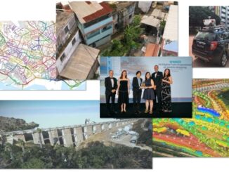
• facebook
  • Twitter
  • Linkedin
  • Youtube
  • Linkedin Group
  • Post a Job
  • Post an Ad
  • Post an Event
  • Post a Directory Listing
  • Post a Press Release
  • Media Kit
  • My Account
  • Login
GoGeomatics
  • MAGAZINE
    • BIM & GIS
    • Community
    • Conference news
    • Earth Observation
    • Education & Careers
    • GEOAI
    • Announcements
    • Reality Capture & Lidar
    • Science
    • Technology
  • Directories
    • ASSOCIATION
    • INDUSTRY
    • EDUCATION
    • Open Data
  • EVENTS
    • GeoIgnite Events
    • Events Calendar
    • GoGeomatics Meetups
  • Services
    • Advertising
    • Marketing
    • Post a Job
    • Post an Ad
    • Post an Event
    • Post a Press Release
    • Post a Directory Listing
    • Media Kit
    • Web Design
  • Find a Job
  • Volunteer
    • Start a GoGeomatics Group
    • Editors & Writers Group
  • About Us
    • About Us
    • Contact Us
    • Frequently Asked Questions
  • Videos
Homeinfrastructure

infrastructure

|
Other

Bim and Digital Twins Digest for September 22, 2022

22 September 2022 GoGeomatics Canada | BIM

Montreal Conference 2022 Expects Large International Crowd,Open BIM has Advantages Over Closed BIM,New Testing Options Offered at Windsor’s VR Cave,Digital Twins and Metaverse are Key to Transforming Infrastructure Montreal Conference 2022 Expects Large International Crowd […]

Community

Geoff Zeiss’ Memory Lives on in Urban Infrastructure Mapping Fund | Carleton FutureFunder

21 September 2022 Jon Murphy | Between the Poles

For over 30 years, Geoff Zeiss devoted his life to the Geospatial industry and community all over the world. It was a life focused on the utility and construction sectors, mapping underground utility infrastructure, BIM, […]

|||
Technology

Scribble Maps Makes Mapping Accessible to All

1 August 2022 GoGeomatics Canada | buffer analysis

Wagner Demonstrates Ease of Use Among Other Strengths On March 22, 2022, during a SUMSF live stream presentation, Jonathan Wagner, CEO of Scribble Maps, demonstrated and discussed how to use Scribble Maps to create digital […]

|||||
Technology

Canadian BIM and Digital Twin Digest for July 28th, 2022

28 July 2022 GoGeomatics Canada | Aecom

BIM Contracting and Infrastructure Digital Twins Businesses can improve on operating infrastructure assets by changing the way they use BIM (Building Information Modelling.) This requires a change in the industry’s mindset.  Integrated use of BIM […]

||||
Technology

Geospatial Commission Demonstrates How To Apply Real Data To A Data Model

24 June 2022 GoGeomatics Canada | Amy Manefield

Preparation begins for NUAR rollout to selected areas. Amy Manefield, Head of Data Operations for the NUAR project sponsored by the Geospatial Commission, presented the topic of applying real data to a data model during […]

||
Technology

Lux Modus Shares the Effectiveness of Creating a 3D Infrastructure Digital Twin

23 June 2022 GoGeomatics Canada | 3D

 An infrastructure digital twin is possible now. SUMSF welcomed President of Lux Modus, Joseph Hlady, to speak on March 22, 2022. His livestream presentation was on creating a 3D infrastructure digital twin.  An Infrastructure Digital […]

||||||
Technology

NYC’s Underground Infrastructure Interoperability is discussed at SUMSF

22 June 2022 GoGeomatics Canada | Alan Leidner

The UNUM project shows the benefits of infrastructure collaborations. At a March 23, 2022, SUMSF live stream presentation, participants were able to hear about the UNUM project and NYC’s approach to underground infrastructure interoperability. The […]

|||
Technology

DGT Combines Traditional and Advanced Technologies to advance Unground Mapping

21 June 2022 GoGeomatics Canada | BIM

Best practices come from using radar tomography to augment underground utility locating. SUMSF live stream on March 23, 2022, treated participants to a presentation by Michael Twohig, Subsurface Utility Mapping with DGT Associates, and Mitchell […]

Posts pagination

« 1 … 7 8 9 10 »

Events

Notice
There are no upcoming events.

View All Events

Services

  • Post a Job
  • Post an Ad
  • Post an Event
  • Post a Directory Listing
  • Post a Press Release
  • Media Kit
  • My Account
  • Login

Jobs

Post a Job
  • Canada Maps and Poster Gallery Volunteer Leads — GeoIgnite 2026
    remote
  • GIS & Data Analytics Lead
    Beaumont, AB
  • Lead Surveyor, Projects/Arpenteur-géomètre principal, projets; arpenteuse-géomètre principale, projets
    North Bay, Thunder Bay
  • Senior GIS Developer
    Calgary, AB
View All Jobs
  • Directories
    • Associations Directory
    • Industry Directory
    • Education Programs
    • Open Data
  • Volunteer
    • Start a GoGeomatics Group
    • Editors & Writers Group
  • About Us
    • GoGeomatics Media Kit
    • Who We Are
    • Contact Us
    • FAQ’s
    • Advertising
    • Marketing
  • Subscribe
GoGeomatics
GoGeomatics is the largest and most popular communications hub promoting the Canadian geospatial community. The business was incorporated in 2011. GoGeomatics hosts over 100 fun, free, location technology networking events each year in cities across Canada.

© 2025 GoGeomatics

  • facebook
  • Twitter
  • Linkedin
  • Youtube
  • Linkedin Group