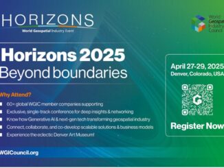
• facebook
  • Twitter
  • Linkedin
  • Youtube
  • Linkedin Group
  • Post a Job
  • Post an Ad
  • Post an Event
  • Post a Directory Listing
  • Post a Press Release
  • Media Kit
  • My Account
  • Shopping Cart
  • Login
GoGeomatics
  • MAGAZINE
    • BIM & GIS
    • Community
    • Conference news
    • Earth Observation
    • Education & Careers
    • GEOAI
    • Announcements
    • Reality Capture & Lidar
    • Science
    • Technology
    • Between the Poles
  • Directories
    • ASSOCIATION
    • INDUSTRY
    • EDUCATION
    • Open Data
  • EVENTS
    • GeoIgnite Events
    • Events Calendar
    • GoGeomatics Meetups
  • Services
    • Advertising
    • Marketing
    • Post a Job
    • Post an Ad
    • Post an Event
    • Post a Press Release
    • Post a Directory Listing
    • Media Kit
    • Web Design
  • Find a Job
  • Volunteer
    • Start a GoGeomatics Group
    • Editors & Writers Group
  • About Us
    • About Us
    • Contact Us
    • Frequently Asked Questions
  • Videos
HomeInteroperability

Interoperability

Community

New plenary speaker joins GeoIgnite 2019 in Ottawa: CEO Nadine Alameh of the Open Geospatial Consortium (OGC)

12 April 2019 GoGeomatics Canada | Canadian conferences

GeoIgnite is thrilled to announce the newest plenary speaker to enhance our agenda June 18th: Nadine Alameh, Chief Executive Officer of the Open Geospatial Consortium (OGC). Nadine is a major leader in international geospatial interoperability […]

Newsmakers & Press Releases

The Open Geospatial Consortium (OGC): proposed GeoRSS Community Standard

29 March 2017 GoGeomatics Newsmakers | 2017

The Open Geospatial Consortium (OGC®) is requesting public comment on the proposed GeoRSS Community Standard.  First available in 2006, GeoRSS is a simple, yet powerful, approach for geo-enabling RSS/Atom feeds – that is, tagging them […]

Newsmakers & Press Releases

Free Webinar March 15th: NRCan, OGC, & USGS Arctic Spatial Data Pilot Demonstration

10 March 2017 GoGeomatics Newsmakers | 2017

The Canada Centre for Mapping and Earth Observation invites you to attend the Arctic Spatial Data Pilot Demonstration Webinar. Managed and organised by the Open Geospatial Consortium (OGC), the Pilot is sponsored by NRCan (Canada Centre […]

No Picture
Technology

Canadian Geomatics Innovation: Ecere Develops a Next Generation GIS

11 January 2017 Ozair Khan | 2014

Not many companies undertake the ambitious goal of creating a new geospatial software suite from scratch. Ecere, a Canadian company based in Gatineau, QuĂ©bec has been developing a software platform that has positioned them to […]

||||||||||
Education & Careers

Easy Access to Data: The CGDI Initiative

28 November 2016 Elaha Akrami | 2013

The Canadian Geospatial Data Infrastructure (CGDI) is an initiative of Natural Resources Canada that began in 2001. The CGDI does not refer to a specific database, but rather a collection of Canadian geospatial resources available […]

No Picture
Newsmakers & Press Releases

Canada Takes Part: Arctic Spatial Data Infrastructure Meets in Anchorage

26 July 2016 GoGeomatics Newsmakers | 2014

The Arctic SDI Board, which includes mapping executives from Canada, Kingdom of Denmark, Finland, Iceland, Norway, Russia, Sweden and the United States, recently met in Anchorage, Alaska to further development of a robust Arctic Spatial […]

Technology

NetCDF: a growing standard for encoding georeferenced data in binary form

5 May 2016 Emmanuel Stefanakis | 2014

Recently, the Open Geospatial Consortium (OGC) has announced an extension to the OGC CF-netCDF 3.0 encoding standard that specifies how Climate and Forecast (CF) netCDF datasets are encoded as OGC coverages. This extended standard facilitates […]

No Picture
Newsmakers & Press Releases

JMap provides instant access to all of the Canadian railway network’s geospatial data

27 April 2016 GoGeomatics Newsmakers | analysis

K2 Geospatial, a leading geospatial software company and the editor of JMap, is pleased to announce the creation of the Canadian Rail Portal. Initiated by the Railway Association of Canada (RAC), the Portal was built […]

Posts pagination

« 1 2 3 4 5 »

Events

Notice
There are no upcoming events.

View All Events

Services

  • Post a Job
  • Post an Ad
  • Post an Event
  • Post a Directory Listing
  • Post a Press Release
  • Media Kit
  • My Account
  • Shopping Cart
  • Login

Jobs

Post a Job
  • Survey Technicians (Field and Office)
    Calgary, Alberta
  • Geospatial Analytical Technician / Technicien, analyses gĂ©ospatiales; technicienne, analyses gĂ©ospatiales
    Peterborough
  • Volunteer Editorial Contributor – Be Part of Canada’s Geomatics Story
    Remote
  • Geomatics Mapping Technician, CAD (GIS)
    British Columbia
View All Jobs
  • Directories
    • Associations Directory
    • Industry Directory
    • Education Programs
    • Open Data
  • Volunteer
    • Start a GoGeomatics Group
    • Editors & Writers Group
  • About Us
    • GoGeomatics Media Kit
    • Who We Are
    • Contact Us
    • FAQ’s
    • Advertising
    • Marketing
  • Subscribe
GoGeomatics
GoGeomatics is the largest and most popular communications hub promoting the Canadian geospatial community. The business was incorporated in 2011. GoGeomatics hosts over 100 fun, free, location technology networking events each year in cities across Canada.

© 2026 GoGeomatics

  • facebook
  • Twitter
  • Linkedin
  • Youtube
  • Linkedin Group