• facebook
  • Twitter
  • Linkedin
  • Youtube
  • Linkedin Group
  • Post a Job
  • Post an Ad
  • Post an Event
  • Post a Directory Listing
  • Post a Press Release
  • Media Kit
  • My Account
  • Login
GoGeomatics
  • MAGAZINE
    • BIM & GIS
    • Community
    • Conference news
    • Earth Observation
    • Education & Careers
    • GEOAI
    • Announcements
    • Reality Capture & Lidar
    • Science
    • Technology
  • Directories
    • ASSOCIATION
    • INDUSTRY
    • EDUCATION
    • Open Data
  • EVENTS
    • GeoIgnite Events
    • Events Calendar
    • GoGeomatics Meetups
  • Services
    • Advertising
    • Marketing
    • Post a Job
    • Post an Ad
    • Post an Event
    • Post a Press Release
    • Post a Directory Listing
    • Media Kit
    • Web Design
  • Find a Job
  • Volunteer
    • Start a GoGeomatics Group
    • Editors & Writers Group
  • About Us
    • About Us
    • Contact Us
    • Frequently Asked Questions
  • Videos
HomeMaintenance

Maintenance

|||
Technology

Skipper NDT Uses Drone to Make Pipeline Maintenance Quicker, Safer, and More Precise

12 August 2022 GoGeomatics Canada | data acquisition

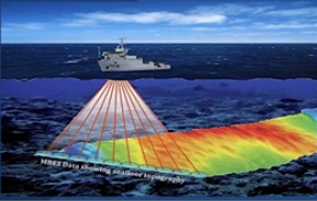
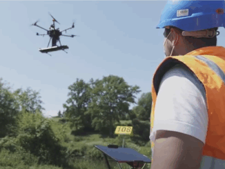
The drone-based platform covers the blind spot in current technology. Skipper NDT Co-founder and COO, Luigi Kassir, spoke on locating underground infrastructure using a drone, during a March 23, 2022, SUMSF (The Subsurface Utility Mapping […]

|||||||
Technology

Cansel Discusses Innovations in LiDAR: Latest Technologies Across Industries

30 June 2022 GoGeomatics Canada | aerial imaging

On April 5, 2022, LiDAR COMEX 2022 held a live stream presentation by Cansel. The topic of “Scan to BIM Solutions for AEC, BIM & VDC Applications” was presented by Amar Kalsi, Cansel Segment Manager […]

||
Community

Making is Connecting: the social meaning of creativity

23 January 2017 Robert Maher | analysis

I spent Christmas in Sydney, Cape Breton. While there, I had the time to read David Gauntlett’s book ‘Making is Connecting’. Gauntlett is Professor,  Creativity and Design at the University of Westminister, UK. He starts with […]

|||
Technology

Predicting the Future of the GIS in Canada

1 December 2016 Gordon Plunkett | 2015

Editors note: This article has been jointly written by Bruce McCormack and Gordon Plunkett. Bios can be found at the bottom of the article. Most people like to predict the future. People are interested in […]

No Picture
Newsmakers & Press Releases

NB 911 Bureau Receives Esri Canada Award of Excellence in GIS

26 October 2016 GoGeomatics Newsmakers | 2012

FREDERICTON, Esri Canada User Conference – October 25, 2016 – Esri Canada today presented the NB 911 Bureau, a branch of the New Brunswick Department of Justice and Public Safety, with an Award of Excellence […]

|
Newsmakers & Press Releases

DigitalGlobe’s Basemap Suite Expands: 250 Million Square Kilometers of 30 cm Imagery

4 October 2016 GoGeomatics Newsmakers | accuracy

DigitalGlobe, Inc. (NYSE: DGI), the global leader in Earth imagery and information about our changing planet, today announced that its online Basemap Suite has reached a significant milestone, with the availability of more than 250 […]

||
Education & Careers

UAVs in Canada – Key Exposures to Loss and Ways to Protect Yourself

3 October 2016 Association of Ontario Land Surveyors | 2014

This article was written by Mark Sampson for the Association of Ontario Land Surveyors. Mark’s contact details are at the bottom of the article and here is a direct link. Drones are referred to interchangeably […]

No Picture
Newsmakers & Press Releases

Teledyne Optech introduces low-cost, automated airborne surveying at GEOINT 2016

11 May 2016 GoGeomatics Newsmakers | 2016

Teledyne Optech is pleased to announce that it will showcase its latest airborne systems including the autonomous Optech Eclipse at the United States Geospatial Intelligence Foundation’s GEOINT symposium in Orlando, FL on May 15-18. As […]

Posts pagination

1 2 … 4 »

Events

Notice
There are no upcoming events.

View All Events

Services

  • Post a Job
  • Post an Ad
  • Post an Event
  • Post a Directory Listing
  • Post a Press Release
  • Media Kit
  • My Account
  • Login

Jobs

Post a Job
  • Canada Maps and Poster Gallery Volunteer Leads — GeoIgnite 2026
    remote
  • GIS & Data Analytics Lead
    Beaumont, AB
  • Lead Surveyor, Projects/Arpenteur-géomètre principal, projets; arpenteuse-géomètre principale, projets
    North Bay, Thunder Bay
  • Senior GIS Developer
    Calgary, AB
View All Jobs
  • Directories
    • Associations Directory
    • Industry Directory
    • Education Programs
    • Open Data
  • Volunteer
    • Start a GoGeomatics Group
    • Editors & Writers Group
  • About Us
    • GoGeomatics Media Kit
    • Who We Are
    • Contact Us
    • FAQ’s
    • Advertising
    • Marketing
  • Subscribe
GoGeomatics
GoGeomatics is the largest and most popular communications hub promoting the Canadian geospatial community. The business was incorporated in 2011. GoGeomatics hosts over 100 fun, free, location technology networking events each year in cities across Canada.

© 2025 GoGeomatics

  • facebook
  • Twitter
  • Linkedin
  • Youtube
  • Linkedin Group