• facebook
  • Twitter
  • Linkedin
  • Youtube
  • Linkedin Group
  • Post a Job
  • Post an Ad
  • Post an Event
  • Post a Directory Listing
  • Post a Press Release
  • Media Kit
  • My Account
  • Login
GoGeomatics
  • MAGAZINE
    • BIM & GIS
    • Community
    • Conference news
    • Earth Observation
    • Education & Careers
    • GEOAI
    • Announcements
    • Reality Capture & Lidar
    • Science
    • Technology
    • Between the Poles
  • Directories
    • ASSOCIATION
    • INDUSTRY
    • EDUCATION
    • Open Data
  • EVENTS
    • GeoIgnite Events
    • Events Calendar
    • GoGeomatics Meetups
  • Services
    • Advertising
    • Marketing
    • Post a Job
    • Post an Ad
    • Post an Event
    • Post a Press Release
    • Post a Directory Listing
    • Media Kit
    • Web Design
  • Find a Job
  • Volunteer
    • Start a GoGeomatics Group
    • Editors & Writers Group
  • About Us
    • About Us
    • Contact Us
    • Frequently Asked Questions
  • Videos
HomeOpen Source

Open Source

|||||||||||||||
Technology

Using Swipe Maps to View Wildfire Destruction in BC

31 July 2017 GIS Program Langara CS | BC

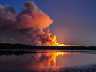
On July 7, 2017 a series of devastating wildfires began in the Cariboo region of British Columbia. The effects of these wildfires will take much time and many resources to make recovery. GIS can have […]

|
Education & Careers

Student Passion for Geography and the Google Summer of Code

27 April 2017 Florin-Daniel Cioloboc | 2016

GoGeomatics has reached across the Atlantic to interview one of our new geospatial contributors in Europe. Join us as we talk with Florin-Daniel Cioloboc about his experiences with the Google Summer of Code project. This […]

||||||||
Education & Careers

QGIS: Performing Viewshed Analysis on Archaeological Sites

27 March 2017 GIS Program Langara CS | analysis

In 1927 a Vancouver bylaw was enacted that limited the height of buildings to a maximum of six stories in height over much of the West End of the city, as illustrated in the Zoning […]

Education & Careers

Google Summer of Code Projects: Open Source Geospatial 4 every student

24 March 2017 Florin-Daniel Cioloboc | 2017

Are you are university student who has solid programming skills, geospatial knowledge and is continuously aiming to become better at developing open source software? Then you are in for a great summer of coding. This […]

|||||||||||||||||||||
Education & Careers

My COGS GIS Education, Part II

22 March 2017 Richard Davenport | 2012

In my first article, I introduced the how and why I chose to attend COGS from the fall of 2014 to spring 2016. In Part 2, I wanted to give some insight into the first-year […]

||
Technology

GIS Open Source versioning tool for a multi-user Distributed Environment (part 2)

22 March 2017 Nicolas Gignac | africa

Cet article est aussi disponible en français. This article is the 2nd part of GIS Open Source versioning tool for a multi-user Distributed Environment and it is an interview of certain stakeholders involved in this versioning open source development. […]

||
Technology

GIS Open Source versioning tool for a multi-user Distributed Environment (part 1)

15 March 2017 Nicolas Gignac | 2014

Editors note: This article has been jointly written by Nicolas Gignac, Dami Sonoiki (eHealth Africa) and Samuel Aiyeoribe (eHealth Africa). These authors would like to thank Yves Moisan, Vincent Mora (Oslandia) and Vincent Picavet (Oslandia) for their […]

||
Technology

Outil de versionnement des données géographiques à code source ouvert pour des environnements multi-contributeurs (partie 1)

15 March 2017 Nicolas Gignac | 2014

Note des éditeurs : Cet article a été écrit conjointement par Nicolas Gignac, Dami Sonoiki (eHealth Africa) et Samuel Aiyeoribe (eHealth Africa). Ces auteurs aimeraient remercier Yves Moisan, Vincent Mora (Oslandia) et Vincent Picavet (Oslandia) pour leur support et […]

Posts pagination

« 1 2 3 4 … 10 »

Events

Notice
There are no upcoming events.

View All Events

Services

  • Post a Job
  • Post an Ad
  • Post an Event
  • Post a Directory Listing
  • Post a Press Release
  • Media Kit
  • My Account
  • Login

Jobs

Post a Job
  • Operations Spatial Data Assistant (Contract)
    Vaughan
  • GIS Analyst
    Saint John, New Brunswick
  • GIS Student Intern
    Elmsdale, Nova Scotia
  • Canada Impact+ Research Chair – Professor (Or Associate Professor)
    Lethbridge, Alberta
View All Jobs
  • Directories
    • Associations Directory
    • Industry Directory
    • Education Programs
    • Open Data
  • Volunteer
    • Start a GoGeomatics Group
    • Editors & Writers Group
  • About Us
    • GoGeomatics Media Kit
    • Who We Are
    • Contact Us
    • FAQ’s
    • Advertising
    • Marketing
  • Subscribe
GoGeomatics
GoGeomatics is the largest and most popular communications hub promoting the Canadian geospatial community. The business was incorporated in 2011. GoGeomatics hosts over 100 fun, free, location technology networking events each year in cities across Canada.

© 2026 GoGeomatics

  • facebook
  • Twitter
  • Linkedin
  • Youtube
  • Linkedin Group