Permafrost
It’s a Wrap! International Geospatial Digest for Dec 16, 2024
As 2024 comes to a close, let’s take a moment to reflect on some of the most significant stories that…
International Geospatial Digest July 31st, 2023
Using Lidar sensors, Hesai and NavVis revolutionize reality capturing Climate Mapping Tool Promoted by NOAA for Better Resilience Planning Localized…
Québec Government announces $600,000 research funding for Laval’s Faculty of Forestry, Geography and Geomatics
The safety and quality of life in Nunavik’s northern villages are important to the Government of Québec. Therefore, the Minister…
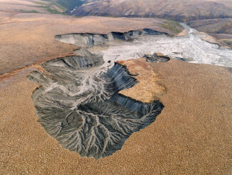
Making Sense of Permafrost Landslides with Government of NWT
Remote Sensing is Finding Answers in the Northwest Territories Remote Sensing is proving itself to be part of the solution…
International Geospatial Briefing May 31st, 2021: Using drone technology to assist with pest management; NOAA’s new approach to earth-observation; Using remote sensing data to observe changes in plant populations; Concept3D’s New 360° Map; Mapping Gaza; Five images that show our changing planet
Drone technology uses thermal imaging to identify feral pests on farmland Two airplane pilots and one aircraft engineer are using…