• facebook
  • Twitter
  • Linkedin
  • Youtube
  • Linkedin Group
  • Post a Job
  • Post an Ad
  • Post an Event
  • Post a Directory Listing
  • Post a Press Release
  • Media Kit
  • My Account
  • Login
GoGeomatics
  • MAGAZINE
    • BIM & GIS
    • Community
    • Conference news
    • Earth Observation
    • Education & Careers
    • GEOAI
    • Announcements
    • Reality Capture & Lidar
    • Science
    • Technology
  • Directories
    • ASSOCIATION
    • INDUSTRY
    • EDUCATION
    • Open Data
  • EVENTS
    • GeoIgnite Events
    • Events Calendar
    • GoGeomatics Meetups
  • Services
    • Advertising
    • Marketing
    • Post a Job
    • Post an Ad
    • Post an Event
    • Post a Press Release
    • Post a Directory Listing
    • Media Kit
    • Web Design
  • Find a Job
  • Volunteer
    • Start a GoGeomatics Group
    • Editors & Writers Group
  • About Us
    • About Us
    • Contact Us
    • Frequently Asked Questions
  • Videos
Homequestion

question

|||Cluster Map of Spatial Autocorrelation
Community

University of Victoria Hosts Advanced Spatial Analysis Course

20 July 2016 Anders Erickson | 2016

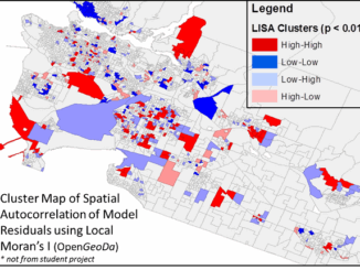
Is neighbourhood socioeconomic status associated with pediatric and childhood injuries? Are such injuries clustered in space? How can I model the spatial dependence in pediatric and childhood injuries in order to help policy makers develop […]

No Picture
Community

The Canadian Remote Sensing Society Wants Your Data

11 July 2016 GoGeomatics Canada | analysis

OK. They don’t want all your data, just some of it. What they really want is your most compelling and interesting data to showcase on their new website  Do you have some drone video you’ve […]

No Picture
Technology

Making a Crow Attack Web Page With Open Source GIS Tools

6 July 2016 GIS Program Langara CS | 2016

Of all the pleasant events that happen in spring, crow attacks rank at the bottom of the pile. Crows become aggressive as the fledgling crows hatch, and attack anything that passes near the nest – […]

|
Education & Careers

Esri Technical Associate Certification: how I passed the test

21 June 2016 Brian Bancroft | advice

A few months ago, I decided to obtain the Esri Associate certification for ArcGIS Desktop and wrote about my reasoning here.  I wanted to take the exam for a few reasons: First, I wanted to have […]

No Picture
Education & Careers

Conversations with Michael Goodchild on Questions of Geography

17 June 2016 Robert Maher | achievement

Recently, I had the opportunity to sit down with Michael Goodchild and talk about his book and Geography.  Michael was my graduate student supervisor in Geography at the University of Western Ontario between 1969-72 and […]

No Picture
Newsmakers & Press Releases

Geomatics Atlantic 2016: Call for Presentations By June 30th

14 June 2016 GoGeomatics Newsmakers | 2013

Call for Presentations It gives me great pleasure to announce that the Canadian Institute of Geomatics – New Brunswick Branch will be hosting Geomatics Atlantic 2016. The event will take place September 26th to September […]

|Alexander Giannelia (Left) - Izaak de Rijcke (right)|Alexander Giannelia (left) Rodolphe Devillers (right)
Community

The Canadian Institute of Geomatics Brings Big Data to Ottawa

9 June 2016 Jon Murphy | 2016

Last week I was among an interesting group of  participants and presenters who came together to discuss Big Data (June 1st, 2016).  The day long event was framed as an exploration of “Big Data: Technology […]

No Picture
Newsmakers & Press Releases

Global GIS Market to Grow Steadily at a CAGR of More Than 10% by 2020

2 June 2016 GoGeomatics Newsmakers | 2020

Technavios market research analyst predicts the global GIS market to grow steadily at a CAGR of more than 10% by 2020. The ability of geographic information systems (GIS) to enhance the end users productivity, decision-making […]

Posts pagination

« 1 … 4 5 6 … 26 »

Events

Notice
There are no upcoming events.

View All Events

Services

  • Post a Job
  • Post an Ad
  • Post an Event
  • Post a Directory Listing
  • Post a Press Release
  • Media Kit
  • My Account
  • Login

Jobs

Post a Job
  • Canada Maps and Poster Gallery Volunteer Leads — GeoIgnite 2026
    remote
  • GIS & Data Analytics Lead
    Beaumont, AB
  • Lead Surveyor, Projects/Arpenteur-géomètre principal, projets; arpenteuse-géomètre principale, projets
    North Bay, Thunder Bay
  • Senior GIS Developer
    Calgary, AB
View All Jobs
  • Directories
    • Associations Directory
    • Industry Directory
    • Education Programs
    • Open Data
  • Volunteer
    • Start a GoGeomatics Group
    • Editors & Writers Group
  • About Us
    • GoGeomatics Media Kit
    • Who We Are
    • Contact Us
    • FAQ’s
    • Advertising
    • Marketing
  • Subscribe
GoGeomatics
GoGeomatics is the largest and most popular communications hub promoting the Canadian geospatial community. The business was incorporated in 2011. GoGeomatics hosts over 100 fun, free, location technology networking events each year in cities across Canada.

© 2025 GoGeomatics

  • facebook
  • Twitter
  • Linkedin
  • Youtube
  • Linkedin Group