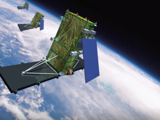
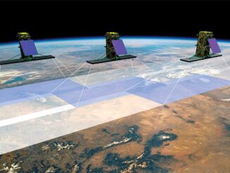
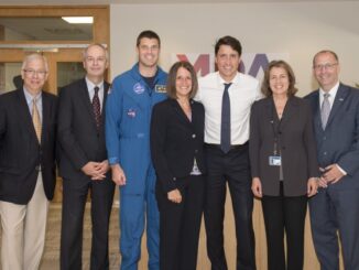
• facebook
  • Twitter
  • Linkedin
  • Youtube
  • Linkedin Group
  • Post a Job
  • Post an Ad
  • Post an Event
  • Post a Directory Listing
  • Post a Press Release
  • Media Kit
  • My Account
  • Login
GoGeomatics
  • MAGAZINE
    • BIM & GIS
    • Community
    • Conference news
    • Earth Observation
    • Education & Careers
    • GEOAI
    • Announcements
    • Reality Capture & Lidar
    • Science
    • Technology
  • Directories
    • ASSOCIATION
    • INDUSTRY
    • EDUCATION
    • Open Data
  • EVENTS
    • GeoIgnite Events
    • Events Calendar
    • GoGeomatics Meetups
  • Services
    • Advertising
    • Marketing
    • Post a Job
    • Post an Ad
    • Post an Event
    • Post a Press Release
    • Post a Directory Listing
    • Media Kit
    • Web Design
  • Find a Job
  • Volunteer
    • Start a GoGeomatics Group
    • Editors & Writers Group
  • About Us
    • About Us
    • Contact Us
    • Frequently Asked Questions
  • Videos
HomeRADARSAT

RADARSAT

|
Newsmakers & Press Releases

Successful launch of Canadian RADARSAT Constellation Mission

13 June 2019 GoGeomatics Newsmakers | agriculture

MDA, a Maxar Technologies company, announced that the three RADARSAT Constellation Mission (RCM) satellites developed by MDA for the Canadian Space Agency are performing according to plan. The satellites launched this morning aboard a SpaceX […]

|||||
Technology

Your Canadian Geospatial Digest for January 21st: GeoIgnite 2019; Vancouver Island University; RADARSAT delay; new drone rules; UrtheCast; Teledyne; Maxar

21 January 2019 GoGeomatics Canada | Canada

GoGeomatics proudly presents: GeoIgnite 2019  GoGeomatics is thrilled to announce the first-ever GeoIgnite Conference in Ottawa! Taking place on June 18th and 19th, 2019, our conference will unite government, business, and thought leaders in the IT and location […]

|||||
Technology

Your Canadian Geospatial Briefing for January 7th: Northwest Angle; RADARSAT delay; mountain mapping; SideWalk Labs; VR and medicine

7 January 2019 GoGeomatics Canada | mountains

Geomatics Correcting a Critical Survey Error on the Canada US border A petition on the White House Website is asking for a 320-square kilometre parcel of land in Minnesota called the Northwest Angle to be […]

|
Technology

Canada’s RADARSAT Constellation launch delayed

23 October 2018 GoGeomatics Canada | Canadian Space Agency

The launch of the Canadian Earth observation satellites (known collectively as the RADARSAT Constellation) has been delayed until February 2019. SpaceX originally planned to send the satellites up for ship location and Arctic observation in […]

Newsmakers & Press Releases

Justin Trudeau Views Final Phase of RADARSAT Constellation Mission (RCM) Construction

12 August 2018 GoGeomatics Newsmakers | Canada

Maxar Technologies (formerly MacDonald, Dettwiler and Associates Ltd.) (NYSE: MAXR; TSX: MAXR), a global technology innovator powering the new space economy, was honored to host the Prime Minister of Canada, the Right Honourable Justin Trudeau, […]

|||||
Technology

Your Canadian Geospatial Briefing for June 25th: Canadian GIS Program Closing; Arctic Coast Guard; Canadian Gov’t and Big Data; Radarsat Satellites; flood imagery; Investing in Canada Plan

25 June 2018 GoGeomatics Canada | Arctic

Why is Red River College closing its GIS program? “Low Industry and labour market demand and difficulty attracting students” as well as budget costs to post-secondary schools in Manitoba have been cited as causes in […]

No Picture
Newsmakers & Press Releases

MDA to deliver space-based SAR for broad-area maritime surveillance

19 October 2016 GoGeomatics Newsmakers | 2016

Vancouver, BC – MacDonald, Dettwiler and Associates Ltd. (“MDA” or the “Company”) (TSX: MDA), a global communications and information company, announced that the Department of National Defence (DND) has exercised an option for a contract […]

|||||
Technology

How Canadian Remote Sensing Was Made Commercially Successful & Exportable

7 September 2016 Robert Ryerson | activity

This piece started as a note on some of my experience as an international consultant in remote sensing specifically and geomatics more generally. But as I looked more and more at the role of consulting, […]

Posts pagination

« 1 2 3 4 … 6 »

Events

Notice
There are no upcoming events.

View All Events

Services

  • Post a Job
  • Post an Ad
  • Post an Event
  • Post a Directory Listing
  • Post a Press Release
  • Media Kit
  • My Account
  • Login

Jobs

Post a Job
  • Canada Maps and Poster Gallery Volunteer Leads — GeoIgnite 2026
    remote
  • GIS & Data Analytics Lead
    Beaumont, AB
  • Lead Surveyor, Projects/Arpenteur-géomètre principal, projets; arpenteuse-géomètre principale, projets
    North Bay, Thunder Bay
  • Senior GIS Developer
    Calgary, AB
View All Jobs
  • Directories
    • Associations Directory
    • Industry Directory
    • Education Programs
    • Open Data
  • Volunteer
    • Start a GoGeomatics Group
    • Editors & Writers Group
  • About Us
    • GoGeomatics Media Kit
    • Who We Are
    • Contact Us
    • FAQ’s
    • Advertising
    • Marketing
  • Subscribe
GoGeomatics
GoGeomatics is the largest and most popular communications hub promoting the Canadian geospatial community. The business was incorporated in 2011. GoGeomatics hosts over 100 fun, free, location technology networking events each year in cities across Canada.

© 2025 GoGeomatics

  • facebook
  • Twitter
  • Linkedin
  • Youtube
  • Linkedin Group