
Community
4 Most Popular GoGeomatics Articles of 2014
It’s that time again! Time to take a look back at the last year on the Magazine and see which articles were the most popular with our readers. We had a lot of great reads […]
It’s that time again! Time to take a look back at the last year on the Magazine and see which articles were the most popular with our readers. We had a lot of great reads […]

PCI Geomatics, a world leading developer of remote sensing and photogrammetric software and systems, today announces the availability of customized Python scripts to be used in conjunction with the company’s latest release of Geomatica. Geomatica […]
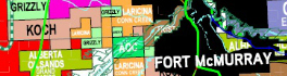
Looking for oil and gas is big business in Western Canada, and like all important ventures it needs proper planning. A small investment in pre-planning in securing relevant maps, data, software, geomatics services and advice […]
New case study from Flowfinity Wireless reveals how Hemmera significantly increased the productivity of field operations with a mobile data collection platform VANCOUVER, BC, Nov. 12, 2014 – Flowfinity Wireless Inc. today released a new […]
the PYXIS innovation™ team is pleased to announce the release of the WorldView™ Software Development Kit (SDK), the world’s first Digital Earth mash-up engine. “Geospatial data integration is the one of the hardest, most expensive […]
NAC Geographic Products Inc. announced the release of NACMMAP Version 5.0 – a standalone NAC enhanced business data mapping and real time assets tracking software. The NAC enhanced mapping software can read data directly from online database servers, […]

Nathan Heazlewood, in one of his recent articles, urges us Geomatics practitioners to be proud of the Geospatial profession. GIS and maps are the basis for many environmental projects because, let’s face it, all environmental […]
Over the past year, the Alberta Geomatics Group (AGG) has embarked on a journey to promote the use of the word Geomatics to encompass all things spatial, GIS, geospatial, location-based, and the like. For many […]