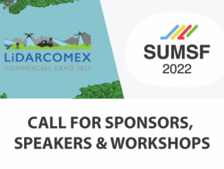
||||
Technology

International Geospatial Briefing May 3: Growing problem of deepfake satellite images; Bird migration map shows huge influx into Michigan; Google Earth timelapse visualizes human footprint; Remote Sensing to study chimoanzees; Mapping of childhood undernutrition in India

False satellite images created by machine learning raise concerns about the reliability of data AI technologies has been used to created false satellite images and the phenomenon of “deepfake geography” will eventually affect the quality […]

|||
Technology

Canadian Geospatial Briefing April 26th: Ontario COVID-19 Vaccine Pharmacy Locator; 5G drones fly over UBC; AI & remote sensing for future Lac à Paul tailings dam; UBC prof uses Sim City-like program to map disease paths; Remote sensing map of Canada’s first highway to the Arctic

UWindsor researcher maps which Windsor neighbourhoods need help accessing vaccines Research by Carina Luo, a geospatial data analyst at the University of Windsor shows there are service gaps in vaccine availability across Ontario. Some areas […]

||||||
Technology

Canadian Geospatial Briefing April 12th: GeoIgnite 2021 Keynotes, Talks, & Panels; Mapping project illuminating links between environment & racism; Remote sensing of agriculture to spot disease risk; Interactive map of Dinosaur Fossils in Canada; A literal map of Canada

Canadian Geomatics & Space Policy & Gov Updates: GeoIgnite Keynotes, Talks, & Panels This year’s GeoIgnite conference will feature many exciting and informative talks in the area of Geospatial and Space Policy. The conference will […]