Technology
International Geospatial Briefing Jan 31st: 1. Exploring the World’s Food Sources; 2. Tracking Sinkholes with Satellites; 3. New Map Shows 2016 Methane Emissions Worldwide; 4. AI and McDonald’s Locations; 5. Satellites Proving Useful in Aftermath of Tonga Eruption
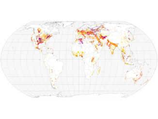
New Interactive Map Explores World’s Food Sources A new application recently published by Visual Capitalist allows users to explore food production around the world like never before. The interactive map allows you to sort and […]