• facebook
  • Twitter
  • Linkedin
  • Youtube
  • Linkedin Group
  • Post a Job
  • Post an Ad
  • Post an Event
  • Post a Directory Listing
  • Post a Press Release
  • Media Kit
  • My Account
  • Login
GoGeomatics
  • MAGAZINE
    • BIM & GIS
    • Community
    • Conference news
    • Earth Observation
    • Education & Careers
    • GEOAI
    • Announcements
    • Reality Capture & Lidar
    • Science
    • Technology
  • Directories
    • ASSOCIATION
    • INDUSTRY
    • EDUCATION
    • Open Data
  • EVENTS
    • GeoIgnite Events
    • Events Calendar
    • GoGeomatics Meetups
  • Services
    • Advertising
    • Marketing
    • Post a Job
    • Post an Ad
    • Post an Event
    • Post a Press Release
    • Post a Directory Listing
    • Media Kit
    • Web Design
  • Find a Job
  • Volunteer
    • Start a GoGeomatics Group
    • Editors & Writers Group
  • About Us
    • About Us
    • Contact Us
    • Frequently Asked Questions
  • Videos
Homesearch

search

||
Technology

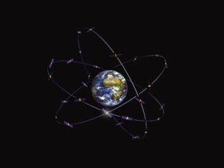
New Galileo navigation system is experiencing clock failures

6 February 2017 David Boileau | 2015

  Since December 15, 2016, the new Galileo global satellite navigation system has been up and running. Unfortunately, there are some technical difficulties on the horizon, having to do with the clocks that are on […]

Education & Careers

Upgrade your Geospatial Skills: leveraging the power of MOOCs

30 January 2017 Florin-Daniel Cioloboc | analysis

What I want to share with you are some resources related to something called Massive Open Online Course (MOOC) where you can learn new skills, refresh your current ones or to simply satisfy your thirst […]

High Resolution Mapping Along the Coastal Zone - https://geomatics.one
Newsmakers & Press Releases

Atlantic Canada: COGS: Geomatics Professionals Coming to Discuss High Resolution Coastal Mapping

30 January 2017 GoGeomatics Newsmakers | 2017

High Resolution Coastal Zone Mapping This collaborative effort by GANS & the CIG will engage the geospatial community & increase awareness on the value that geospatial data provides to effective decision making January 30, 2017 (Halifax, NS) – Next week […]

||
Community

Making is Connecting: the social meaning of creativity

23 January 2017 Robert Maher | analysis

I spent Christmas in Sydney, Cape Breton. While there, I had the time to read David Gauntlett’s book ‘Making is Connecting’. Gauntlett is Professor,  Creativity and Design at the University of Westminister, UK. He starts with […]

||
Technology

The Future of GIS Software? QGIS A Popular Open-Source GIS for the Masses

16 January 2017 Francis Guo | 2015

In today’s geomatics society, ArcGIS, developed by Esri, is a giant and dominates the GIS software market. However, there are some other great and powerful GIS software applications. QGIS is a typical GIS application among […]

No Picture
Technology

Canadian Geomatics Innovation: Ecere Develops a Next Generation GIS

11 January 2017 Ozair Khan | 2014

Not many companies undertake the ambitious goal of creating a new geospatial software suite from scratch. Ecere, a Canadian company based in Gatineau, Québec has been developing a software platform that has positioned them to […]

Newsmakers & Press Releases

Feb 7-8: Two Day Workshop on High Resolution Mapping Along Coastal Zones

6 January 2017 GoGeomatics Newsmakers | 2016

The coastal zone, that dynamic geographic region where the interaction of the sea and land occurs, is vital to the lifestyle and economy of Atlantic Canada. Having quality geospatial data is essential for mapping coastal […]

|
Education & Careers

How to Start Your Career in GIS

4 January 2017 Priscilla Ancinelli | advice

You are reaching the point of your life where you are finishing up your last year of college or university and your next step is finding a Geographic Information Systems (GIS) entry-level job. You are […]

Posts pagination

« 1 … 4 5 6 … 47 »

Events

Notice
There are no upcoming events.

View All Events

Services

  • Post a Job
  • Post an Ad
  • Post an Event
  • Post a Directory Listing
  • Post a Press Release
  • Media Kit
  • My Account
  • Login

Jobs

Post a Job
  • Canada Maps and Poster Gallery Volunteer Leads — GeoIgnite 2026
    remote
  • GIS & Data Analytics Lead
    Beaumont, AB
  • Lead Surveyor, Projects/Arpenteur-géomètre principal, projets; arpenteuse-géomètre principale, projets
    North Bay, Thunder Bay
  • Senior GIS Developer
    Calgary, AB
View All Jobs
  • Directories
    • Associations Directory
    • Industry Directory
    • Education Programs
    • Open Data
  • Volunteer
    • Start a GoGeomatics Group
    • Editors & Writers Group
  • About Us
    • GoGeomatics Media Kit
    • Who We Are
    • Contact Us
    • FAQ’s
    • Advertising
    • Marketing
  • Subscribe
GoGeomatics
GoGeomatics is the largest and most popular communications hub promoting the Canadian geospatial community. The business was incorporated in 2011. GoGeomatics hosts over 100 fun, free, location technology networking events each year in cities across Canada.

© 2025 GoGeomatics

  • facebook
  • Twitter
  • Linkedin
  • Youtube
  • Linkedin Group