
Community
A Canadian Perspective: Idiots who use Drones
In the past few months there have been quite a few articles that have shown UAV’s or drones in a negative light. It’s not only humans that have been critical of UAV’s and their use […]
In the past few months there have been quite a few articles that have shown UAV’s or drones in a negative light. It’s not only humans that have been critical of UAV’s and their use […]
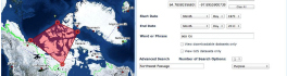
In February 2005, Google Maps was launched as a desktop web mapping service. A few months later, in June 2005, Google Earth was released for personal computers. Since then, people around the globe have been […]
The global commercial drone market size is expected to reach USD 2.07 billion by 2022, according to a new report by Grand View Research, Inc. Increased utility in law enforcement and agricultural applications is expected […]
It is with great pleasure that I want to introduce a new Web Mapping and Geospatial textbook to the Canadian geomatics community. Prof. Emmanuel Stefanakis (University of New Brunswick, Canada) has authored an introductory textbook on […]

The third international conference on Unmanned Aerial Vehicles in Geomatics (UAV-g 2015) is coming to Canada later this summer for the first time ever, this time in Toronto, Ontario. Attribution: Prayitno Increasingly, UAVs are […]
BlackBridge, a leading provider of satellite imagery and geospatial solutions, announced today that it has entered into a definitive agreement for Planet Labs to acquire the RapidEye suite of core offerings. Planet Labs is a […]
The growing interest in providing open data access has long been integrated into the field of Geomatics. However, the use of Geomatics within open data portals is relatively uncommon. This inclusion provides an interactive and […]
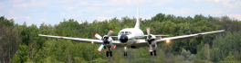
June 23rd marked a special day in the history of aviation and space in Canada. A very special aircraft, a Convair-580, with its advanced Synthetic Aperture Radar (SAR) sensors, made its final flight after setting […]