• facebook
  • Twitter
  • Linkedin
  • Youtube
  • Linkedin Group
  • Post a Job
  • Post an Ad
  • Post an Event
  • Post a Directory Listing
  • Post a Press Release
  • Media Kit
  • My Account
  • Login
GoGeomatics
  • MAGAZINE
    • BIM & GIS
    • Community
    • Conference news
    • Earth Observation
    • Education & Careers
    • GEOAI
    • Announcements
    • Reality Capture & Lidar
    • Science
    • Technology
  • Directories
    • ASSOCIATION
    • INDUSTRY
    • EDUCATION
    • Open Data
  • EVENTS
    • GeoIgnite Events
    • Events Calendar
    • GoGeomatics Meetups
  • Services
    • Advertising
    • Marketing
    • Post a Job
    • Post an Ad
    • Post an Event
    • Post a Press Release
    • Post a Directory Listing
    • Media Kit
    • Web Design
  • Find a Job
  • Volunteer
    • Start a GoGeomatics Group
    • Editors & Writers Group
  • About Us
    • About Us
    • Contact Us
    • Frequently Asked Questions
  • Videos
HomeStatistics Canada

Statistics Canada

||||
Technology

The Linkable Open Data Environment (LODE): Supporting Geospatial Analysis with Open Data

9 September 2020 Julia Conzon and Joseph Kuchar | Data Exploration and Integration Lab

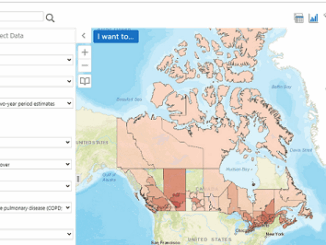
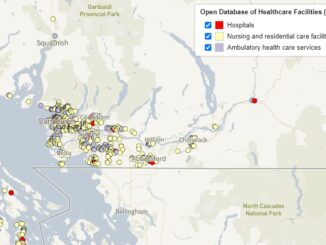
Over the past 2 years Statistics Canada’s Data Exploration and Integration Lab (DEIL) has launched and developed the Linkable Open Data Environment (LODE), an exploratory initiative that aims at enhancing the use and harmonization of […]

|||
Technology

What is the Canadian Statistical Geospatial Explorer?

12 August 2020 Tanya Tejassvi | Canada

Statistics Canada produces statistics that help Canadians better understand their country. The agency ensures Canadians have the key information on Canada’s economy, society and environment that can help function effectively as citizens and decision makers. […]

||||
Community

Leadership in Times of Disruption: GeoIgnite 2020 talks at a Glance

13 July 2020 Saeideh Hejazi | Aboriginal

Canada’s geospatial community is gathering next week for GeoIgnite 2020. The second annual conference is being held online this year from the 22nd to the 24th of July. The theme for 2020 is: Leadership in […]

||||||||||||||||||||
Newsmakers & Press Releases

Eric Loubier -DG- CCMEO Keynote Announcement GeoIgnite 2020 Online

24 June 2020 Jon Murphy | 2020

The GeoIgnite conference committee is excited to announce our keynote is the Director General, Eric Loubier, Canada Centre of Mapping and Earth Observation (CCMEO/NRCan).  This is Canada’s National Geospatial Leadership event July 22-24, 2020. Eric […]

||||
Newsmakers & Press Releases

GeoIgnite: Leadership in Times of Disruption

16 June 2020 GoGeomatics Canada | Agriculture Canada

Join us virtually this year for Canada’s National Geospatial Leadership: GeoIgnite conference on July 22nd to 24th, 2020! This event will showcase Canadian geospatial community and leaders of Canada’s location technology sector. Join us for talks, […]

|
Education & Careers

Using GIS to study health care services and utilization––from local to national

24 July 2017 Anders Erickson | communication

Access to timely and quality health care is an important determinant of health and well-being. Despite universal health coverage in Canada, there exists socio-demographic, financial and physical geographic barriers that limit the accessibility to health […]

|
Education & Careers

It’s a Geospatial world we live in: Find Your Happy Place

1 November 2016 Anders Erickson | analysis

When does a space become a place? There are a myriad of small open spaces and buildings throughout towns and cities across Canada that offer places for play, walking, social gathering, and contemplation that are […]

|||||||||
Technology

QGIS & WorldClim: Using Zonal Statistics to Map Temperature Patterns

31 October 2016 GIS Program Langara CS | Alaska

There has never been a time in the history of GIS when so much free, high quality data has been available. As an example, the WorldClim site (http://www.worldclim.org/) offers temperature raster data, on a global […]

Posts pagination

« 1 2 3 4 »

Events

Notice
There are no upcoming events.

View All Events

Services

  • Post a Job
  • Post an Ad
  • Post an Event
  • Post a Directory Listing
  • Post a Press Release
  • Media Kit
  • My Account
  • Login

Jobs

Post a Job
  • Canada Maps and Poster Gallery Volunteer Leads — GeoIgnite 2026
    remote
  • GIS & Data Analytics Lead
    Beaumont, AB
  • Lead Surveyor, Projects/Arpenteur-géomètre principal, projets; arpenteuse-géomètre principale, projets
    North Bay, Thunder Bay
  • Senior GIS Developer
    Calgary, AB
View All Jobs
  • Directories
    • Associations Directory
    • Industry Directory
    • Education Programs
    • Open Data
  • Volunteer
    • Start a GoGeomatics Group
    • Editors & Writers Group
  • About Us
    • GoGeomatics Media Kit
    • Who We Are
    • Contact Us
    • FAQ’s
    • Advertising
    • Marketing
  • Subscribe
GoGeomatics
GoGeomatics is the largest and most popular communications hub promoting the Canadian geospatial community. The business was incorporated in 2011. GoGeomatics hosts over 100 fun, free, location technology networking events each year in cities across Canada.

© 2025 GoGeomatics

  • facebook
  • Twitter
  • Linkedin
  • Youtube
  • Linkedin Group