• facebook
  • Twitter
  • Linkedin
  • Youtube
  • Linkedin Group
  • Post a Job
  • Post an Ad
  • Post an Event
  • Post a Directory Listing
  • Post a Press Release
  • Media Kit
  • My Account
  • Login
GoGeomatics
  • MAGAZINE
    • BIM & GIS
    • Community
    • Conference news
    • Earth Observation
    • Education & Careers
    • GEOAI
    • Announcements
    • Reality Capture & Lidar
    • Science
    • Technology
  • Directories
    • ASSOCIATION
    • INDUSTRY
    • EDUCATION
    • Open Data
  • EVENTS
    • GeoIgnite Events
    • Events Calendar
    • GoGeomatics Meetups
  • Services
    • Advertising
    • Marketing
    • Post a Job
    • Post an Ad
    • Post an Event
    • Post a Press Release
    • Post a Directory Listing
    • Media Kit
    • Web Design
  • Find a Job
  • Volunteer
    • Start a GoGeomatics Group
    • Editors & Writers Group
  • About Us
    • About Us
    • Contact Us
    • Frequently Asked Questions
  • Videos
HomeStudy

Study

No Picture
Community

Canadian Forestry: Landscape Mapping of Whole Tree Inherent Wood Properties

23 July 2013 Mathew Leitch | application

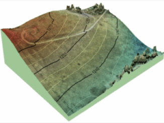
Introduction The forest industry is undergoing a major shift in how it conducts business due mainly from increased competition from other regions of the world.  In particular the southern Hemisphere has become a major provider […]

GEOINT Canada||Kandahar Airfield Afghanistan Neil Thompson|Neil Thompson with Canadian Military Geo Tech's in the field
Education & Careers

Neil Thompson: Geospatial Intelligence & Canadian Military

23 July 2013 GoGeomatics Canada | 2014

GoGeomatics had the chance to interview Neil Thompson, the Managing partner of the WCGroup. Neil is also the former Director of Geospatial Intelligence for the Canadian Forces and a retired Colonel.  You can have a […]

UAV Mapping||||||||||||
Education & Careers

Canadian UAV Company Maps Forest Fire Damage in Alberta

8 July 2013 Brent Wanless | 3D

Industry and public awareness for commercial applications of UAV technology has increased significantly in Canada and throughout North America. Initially the technology was primarily developed for military use, where the application requirements are different. Design […]

||
Community

The Mapping & Analysis of Violent Injury in Canadian Cities

10 June 2013 Edgar Baculi | 2013

After experiencing another Toronto social event thanks to GoGeomatics Canada, I am reminded of how a night out can increase the chance of injury. Perhaps that’s an odd connection to make in the eyes of […]

Community

Updated 2013 Canadian Geomatics Conferences & Events: GIS, Remote Sensing, Surveying

1 May 2013 GoGeomatics Canada | 2012

We decided to update our list of events and conferences that might be of interest to the geomatics community for 2013 so here it is. Conferences and geomatics events are good for your career health. […]

Original map by John Snow showing the clusters of cholera cases in the London epidemic of 1854
Education & Careers

Looking Back at my First Year, GIS & Geographic Analysis at Ryerson University

1 May 2013 Edgar Baculi | analysis

After successfully completing my first year at Ryerson University in Toronto, I wanted to share some thoughts about my experiences. I am excited to be joining an industry that is so important, and literally,  a […]

No Picture
Community

NRCan, GeoConnections, CGDI, & the Canadian Geomatics Round Table

1 April 2013 Jon Murphy | 2012

GoGeomatics Canada got in touch with Natural Resources Canada (NRCan) in order to ask them about all the most recent goings on over there on Booth Street in Ottawa.  Michelle Viau, the Communications Advisor in […]

No Picture
Education & Careers

Tara Seitz: A Woman in a Man’s GIS World

27 March 2013 GoGeomatics Canada | 2013

Editors Note: This article was written by Tara Seitz but posted under our generic GoGeomatics account.  To learn more about Tara please see this article about her and her work. If I line up ten […]

Posts pagination

« 1 … 12 13 14 … 17 »

Events

Notice
There are no upcoming events.

View All Events

Services

  • Post a Job
  • Post an Ad
  • Post an Event
  • Post a Directory Listing
  • Post a Press Release
  • Media Kit
  • My Account
  • Login

Jobs

Post a Job
  • Canada Maps and Poster Gallery Volunteer Leads — GeoIgnite 2026
    remote
  • GIS & Data Analytics Lead
    Beaumont, AB
  • Lead Surveyor, Projects/Arpenteur-géomètre principal, projets; arpenteuse-géomètre principale, projets
    North Bay, Thunder Bay
  • Senior GIS Developer
    Calgary, AB
View All Jobs
  • Directories
    • Associations Directory
    • Industry Directory
    • Education Programs
    • Open Data
  • Volunteer
    • Start a GoGeomatics Group
    • Editors & Writers Group
  • About Us
    • GoGeomatics Media Kit
    • Who We Are
    • Contact Us
    • FAQ’s
    • Advertising
    • Marketing
  • Subscribe
GoGeomatics
GoGeomatics is the largest and most popular communications hub promoting the Canadian geospatial community. The business was incorporated in 2011. GoGeomatics hosts over 100 fun, free, location technology networking events each year in cities across Canada.

© 2025 GoGeomatics

  • facebook
  • Twitter
  • Linkedin
  • Youtube
  • Linkedin Group