• facebook
  • Twitter
  • Linkedin
  • Youtube
  • Linkedin Group
  • Post a Job
  • Post an Ad
  • Post an Event
  • Post a Directory Listing
  • Post a Press Release
  • Media Kit
  • My Account
  • Login
GoGeomatics
  • MAGAZINE
    • BIM & GIS
    • Community
    • Conference news
    • Earth Observation
    • Education & Careers
    • GEOAI
    • Announcements
    • Reality Capture & Lidar
    • Science
    • Technology
  • Directories
    • ASSOCIATION
    • INDUSTRY
    • EDUCATION
    • Open Data
  • EVENTS
    • GeoIgnite Events
    • Events Calendar
    • GoGeomatics Meetups
  • Services
    • Advertising
    • Marketing
    • Post a Job
    • Post an Ad
    • Post an Event
    • Post a Press Release
    • Post a Directory Listing
    • Media Kit
    • Web Design
  • Find a Job
  • Volunteer
    • Start a GoGeomatics Group
    • Editors & Writers Group
  • About Us
    • About Us
    • Contact Us
    • Frequently Asked Questions
  • Videos
HomeSUMSForum

SUMSForum

Technology

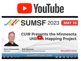
SUMSF 2023: CUIR Presents the Minnesota Utilities Mapping Project

9 July 2023 GoGeomatics Canada | Bob Basques

Steve Slusarenko, Director of CUIR (Canadian Underground Infrastructure Register) and Bob Basques, Technical Director of SharedGeo, presented the “Case for Canadian Underground Infrastructure Register” during their May 16, 2023,  SUMSF 2023 livestream presentation called, “CUIR […]

|||||||||
Technology

Augview Brings Subsurface Utility Mapping to Life in Real Time

19 August 2022 GoGeomatics Canada | AR

Augmented Reality brings benefits and technical challenges to the world of utility mapping. Michael Bundock, CEO and Founder of Augview Ltd, engaged participants when he spoke during a livestream presentation on March 23, 2022, at […]

|||
Technology

Skipper NDT Uses Drone to Make Pipeline Maintenance Quicker, Safer, and More Precise

12 August 2022 GoGeomatics Canada | data acquisition

The drone-based platform covers the blind spot in current technology. Skipper NDT Co-founder and COO, Luigi Kassir, spoke on locating underground infrastructure using a drone, during a March 23, 2022, SUMSF (The Subsurface Utility Mapping […]

|||
Technology

Locusview Discusses the Importance of Optimizing Processes with Digital Management Tools

9 August 2022 GoGeomatics Canada | business values

Having a digital mobile workflow will help utilities as the infrastructure construction sector is booming globally.  Optimizing the asset booking process with digital construction management tools was the topic of the SUMSF, March 22, 2022, […]

|||
Technology

Scribble Maps Makes Mapping Accessible to All

1 August 2022 GoGeomatics Canada | buffer analysis

Wagner Demonstrates Ease of Use Among Other Strengths On March 22, 2022, during a SUMSF live stream presentation, Jonathan Wagner, CEO of Scribble Maps, demonstrated and discussed how to use Scribble Maps to create digital […]

||
Technology

Reduct NV Discusses Concept to Challenge Today’s Perspective on Gyro-Mapping

28 July 2022 GoGeomatics Canada | concept

Product-as-a-service can make Gyro-Mapping more affordable for all. Otto Ballintijn, CEO of Reduct NV, introduced Product-as-a-service (Paas) as a concept during a March 22, 2022, livestream at SUMSF. Reduct NV, a world leader in Gyro-Mapping […]

||
Technology

Geosystems France Discusses Initiative to Reduce Damage to Underground Utility Networks

18 July 2022 GoGeomatics Canada | 3D modeling

The DT-DICT Is Reducing Damages Patrice Lemire, Directeur General Geosystems France, was the keynote speaker for the March 22, 2022, SUMSF livestream. The topic of interest was “Reducing damage to underground utility networks with the […]

||||||||||
Technology

The SLA Presents Their Utility Mapping Ecosystem for Digital Workflows

26 June 2022 GoGeomatics Canada | 3D digital

Singapore is tapping into the potential of underground space. On March 23, 2022, participants of SUMSF were treated to a live stream presentation by Victor Khoo, Director of Singapore Land Authority (SLA). The topic of […]

Posts pagination

1 2 3 »

Events

Notice
There are no upcoming events.

View All Events

Services

  • Post a Job
  • Post an Ad
  • Post an Event
  • Post a Directory Listing
  • Post a Press Release
  • Media Kit
  • My Account
  • Login

Jobs

Post a Job
  • Canada Maps and Poster Gallery Volunteer Leads — GeoIgnite 2026
    remote
  • GIS & Data Analytics Lead
    Beaumont, AB
  • Lead Surveyor, Projects/Arpenteur-géomètre principal, projets; arpenteuse-géomètre principale, projets
    North Bay, Thunder Bay
  • Senior GIS Developer
    Calgary, AB
View All Jobs
  • Directories
    • Associations Directory
    • Industry Directory
    • Education Programs
    • Open Data
  • Volunteer
    • Start a GoGeomatics Group
    • Editors & Writers Group
  • About Us
    • GoGeomatics Media Kit
    • Who We Are
    • Contact Us
    • FAQ’s
    • Advertising
    • Marketing
  • Subscribe
GoGeomatics
GoGeomatics is the largest and most popular communications hub promoting the Canadian geospatial community. The business was incorporated in 2011. GoGeomatics hosts over 100 fun, free, location technology networking events each year in cities across Canada.

© 2025 GoGeomatics

  • facebook
  • Twitter
  • Linkedin
  • Youtube
  • Linkedin Group