• facebook
  • Twitter
  • Linkedin
  • Youtube
  • Linkedin Group
  • Post a Job
  • Post an Ad
  • Post an Event
  • Post a Directory Listing
  • Post a Press Release
  • Media Kit
  • My Account
  • Login
GoGeomatics
  • MAGAZINE
    • BIM & GIS
    • Community
    • Conference news
    • Earth Observation
    • Education & Careers
    • GEOAI
    • Announcements
    • Reality Capture & Lidar
    • Science
    • Technology
  • Directories
    • ASSOCIATION
    • INDUSTRY
    • EDUCATION
    • Open Data
  • EVENTS
    • GeoIgnite Events
    • Events Calendar
    • GoGeomatics Meetups
  • Services
    • Advertising
    • Marketing
    • Post a Job
    • Post an Ad
    • Post an Event
    • Post a Press Release
    • Post a Directory Listing
    • Media Kit
    • Web Design
  • Find a Job
  • Volunteer
    • Start a GoGeomatics Group
    • Editors & Writers Group
  • About Us
    • About Us
    • Contact Us
    • Frequently Asked Questions
  • Videos
Hometour

tour

Lidar / GPS Terrain Modelling for Ice Jam Emergency Response|Lidar / GPS Terrain Modelling for Ice Jam Emergency Response
Community

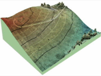
Prince George BC: Lidar / GPS Terrain Modelling for Ice Jam Emergency Response

7 November 2013 McElhanney | Acquisition

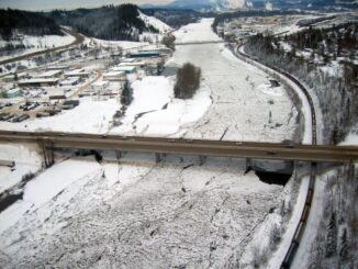
Unprecedented ice jams led to extensive flooding in Prince George as temperatures dipped to record lows in the winter of 2007/2008. City officials declared a state of local emergency on December 11, 2007, ordering dozens […]

No Picture
Education & Careers

Women in Geomatics: Jaime Simpson – Pipeline Surveying in Alberta

29 October 2013 GoGeomatics Canada | alberta

GoGeomatics: We are talking to Jaime Simpson, formerly an Ottawa resident and recent graduate of Carleton University’s Geomatics program. Jaime recently moved to Calgary from Ottawa to pursue job opportunities in GIS and geomatics. GoGeomatics: […]

No Picture
Community

LiDAR Reveals Hidden Archaeological Ruins

4 September 2013 McElhanney | 2012

In April 2012, McElhanney conducted an extensive aerial LiDAR survey in support of archaeological research in Cambodia. It was the first such project in Southeast Asia and the world’s largest archaeological LiDAR survey to date, […]

No Picture
Community

TomTom chooses DMTI Spatial as provider of Canadian location data

6 August 2013 Phil Kaszuba, President, DMTI Spatial | CCA

A lot of planning goes into our summer road trips as we plot our routes, alternate routes and the occasional sight-seeing detour. The age of the passenger seat navigator, lost behind full sheet paper maps […]

UAV Mapping||||||||||||
Education & Careers

Canadian UAV Company Maps Forest Fire Damage in Alberta

8 July 2013 Brent Wanless | 3D

Industry and public awareness for commercial applications of UAV technology has increased significantly in Canada and throughout North America. Initially the technology was primarily developed for military use, where the application requirements are different. Design […]

No Picture
Community

Pictures from URISA Ontario: Be Spatial ’13 & GISP

13 May 2013 GoGeomatics Canada | 2013

On May 7th GoGeomatics Canada attended the URISA Ontario: Be Spatial 2013 conference  in Stoney Creek. If you follow us on Twitter @GoGeomatics you would have seen the blackberry photos of the event.   We also […]

No Picture
Education & Careers

The Death of Cartography and the Rise of the Machines

22 April 2013 Andrew Raal | analysis

This article explores how technology has influenced map making and how cartography requirements have changed, and what skill sets one needs to make the modern map. Cartography: Back in the mid 1980’ in geology departments […]

No Picture
Education & Careers

Canadian National Surveyors’ Conference 2013 from June 18-21

5 April 2013 Jon Murphy | 2013

Are you excited about the upcoming National Surveyors’ Conference 2013 from June 18-21 in Niagara Falls? You should be! In case the previous article wasn’t enough to encourage you, here are some extra tidbits. Recruiting […]

Posts pagination

« 1 … 5 6 7 … 9 »

Events

Notice
There are no upcoming events.

View All Events

Services

  • Post a Job
  • Post an Ad
  • Post an Event
  • Post a Directory Listing
  • Post a Press Release
  • Media Kit
  • My Account
  • Login

Jobs

Post a Job
  • Canada Maps and Poster Gallery Volunteer Leads — GeoIgnite 2026
    remote
  • GIS & Data Analytics Lead
    Beaumont, AB
  • Lead Surveyor, Projects/Arpenteur-géomètre principal, projets; arpenteuse-géomètre principale, projets
    North Bay, Thunder Bay
  • Senior GIS Developer
    Calgary, AB
View All Jobs
  • Directories
    • Associations Directory
    • Industry Directory
    • Education Programs
    • Open Data
  • Volunteer
    • Start a GoGeomatics Group
    • Editors & Writers Group
  • About Us
    • GoGeomatics Media Kit
    • Who We Are
    • Contact Us
    • FAQ’s
    • Advertising
    • Marketing
  • Subscribe
GoGeomatics
GoGeomatics is the largest and most popular communications hub promoting the Canadian geospatial community. The business was incorporated in 2011. GoGeomatics hosts over 100 fun, free, location technology networking events each year in cities across Canada.

© 2025 GoGeomatics

  • facebook
  • Twitter
  • Linkedin
  • Youtube
  • Linkedin Group