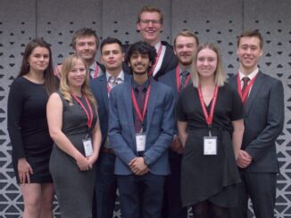
University of Waterloo

PredictION: Routing & Modeling App for Proposed Transit Projects

PredictION is an app that provides transit authorities with a unique approach to engage and inform the public. By making…

Esri ECCE App Challenge Lets Students Develop New Skills

Back in March, GoGeomatics Canada introduced the Esri Canada Centres of Excellence App Challenge while the competition was still underway.…

University of Waterloo Students Win the Esri Canada GIS Centres of Excellence App Challenge

PredictION helps citizens understand the impact of proposed transit changes to their daily commute TORONTO – Esri Canada congratulates Jonathan…

Spring Speaker Series: Intergraph & Education in Ottawa, Toronto

We’re pleased to announce a new series of talks at the upcoming GoGeomatics Socials in Ottawa and Toronto. Brad Schmidt…

GIS Day is Just around the Corner

This November 19, the geomatics world will celebrate the 15th annual GIS Day. GIS Day is part of Geography Awareness…

Geospatial Computing Workshop – an Interdisciplinary Approach

An upcoming two-day workshop in Kitchener, Ontario hopes to generate new relationships between academia, industry, and government around geospatial computing.…

University Perspective – Esri Canada Centres of Excellence

Canadian students are busy getting ready for the start of a brand new school year. And at six schools across…

Dr. Brent Hall Talks to GoGeomatics about Esri Canada Centres of Excellence

GoGeomatics recently published a press release on the launch of the Esri Canada GIS Centres of Excellence in Higher Education.…

Looking Ahead to the Fall: Geomatics in Canada 2014

The summer is a time of year when most of us slow down a little bit. Just like everyone else,…

Esri Canada Launches GIS Centres of Excellence in Higher Education

TORONTO – July 29, 2014 – Esri Canada, the leading provider of geographic information system (GIS) solutions, is pleased to…

Geospatial Niagara – Geographic Education Town Hall Meeting

So, what do you do when approximately 8,000 practitioners of the Humanities and Social Sciences domain converge at the university…

GIS Team Leader

Pat has worked in both the public and private GIS sectors and we were fortunate to have him share his experiences with us. He is currently the GIS Team Leader for all projects that require GIS services.

The office that he works at is involved in Environmental Management, and there are approximately 50 on-going projects. The work environment and turnaround times are usually very fast pace and it is his duty to make sure that the GIS services are delivered with the best quality possible and on time.