
Community

PCI Geomatics, a world leading developer of remote sensing and photogrammetric software and systems, today announces the availability of customized Python scripts to be used in conjunction with the company’s latest release of Geomatica. Geomatica […]

David Lepage, in his blog for Axiom News, expresses concern for “the map is not the territory” in a community economy. One of the cornerstones of rural economic development is asset mapping (see Kretzmann and […]
Montreal, Canada, November25th, 2014 – The most important part of mapping, inspections and monitoring by robotic aircraft, is not the airshow – it’s the quality of the imagery and analysis that is enabled. SimActive Inc., […]
The Canadian Council on Geomatics (CCOG) has been around for over 40 years. Despite that, many people in geomatics aren’t aware of the significant role this federal-provincial-territorial government organization plays in the sector. To help […]
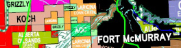
Looking for oil and gas is big business in Western Canada, and like all important ventures it needs proper planning. A small investment in pre-planning in securing relevant maps, data, software, geomatics services and advice […]
Esri Canada supports Planet in Focus Environmental Film Festival’s Closing Film Toronto, ON – November 4, 2014 – Canadians may be aware of the unsightly presence of chewing gum on the streets but they are […]