
what3words, the multi-award winning location reference system, has today announced that six national mapping agencies have adopted 3-word addresses. Used to input and share locations within national online geoportals, what3words is making it simpler for businesses, governments, and citizens to find, share and remember addresses.
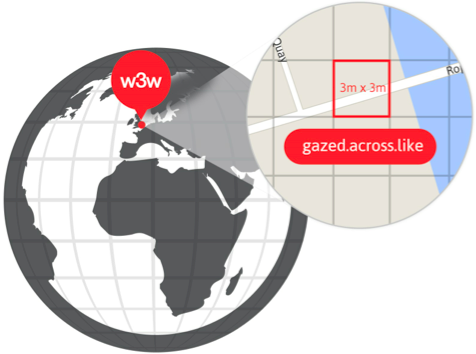
Based on a global grid of 57 trillion squares, what3words gives every 3m x 3m in the world a unique 3-word address. Available in thirteen languages, what3words is used by consumers, delivery companies, navigation tools, governments, logistics firms, travel guides and NGOs. It’s more precise than traditional addresses, simpler than descriptions, and easier to communicate and remember than long strings of GPS coordinates.
Geoportals are an integral part of any national, cadastral, or commercial mapping agency’s offering, providing businesses and consumers with vital geographic information. The datasets range from information about land ownership, taxing of land parcels and defining borders, to providing population statistics, changes in land use and integration of transport networks.
Whilst geoportals offer a wealth of detail, the user experience can be complicated and confusing. By integrating what3words into geoportals systems it makes it easier for individuals and businesses to share precise locations with a simple 3-word address.
Chris Sheldrick, CEO and Co-Founder of what3words commented: “Geoportals provide users with a huge amount of data that can sometimes alienate all but the mapping expert. what3words is making it simpler and easier for individuals and businesses to discover and share locations, helping unleash the power of geographic data.”
what3words has been adopted by Switzerland’s Federal Office for Topography, The French Institut Géographique National International (IGN), The Norwegian Mapping Authority, Kartverket, Finland’s Maanmittauslaitos (the National Land Survey), Geo-System Poland and Suriname’s MI-GLIS.
As 3-word addresses are fixed and unique, meaning they can always be found. The system works offline, using GPS without needing mobile data, and has built-in error detection to ensure the user always selects the location they intended.
Since its launch in 2013, what3words has experienced tremendous success and with over twenty major awards has become one of the most lauded UK startups in recent times. In 2015, the company was awarded the prestigious Cannes Lions Grand Prix for Innovation and was named in the Nominet 100 alongside the likes of Google’s Project Loon. Earlier this year the business was awarded an exclusive D&AD Black Pencil, two prestigious Webby Awards and CEO Chris Sheldrick was named EY’s British Accelerating Entrepreneur.
Please see below for further information:
- Switzerland’s Federal Office for Topography (swisstopo)
3-word addresses are helping users discover and share precise locations – from building entrances to a remote hiking trail or ski run.
Following a massive map update project, the IGN has integrated 3-word addresses into its online maps for France and the Republic of Mali. It currently offers the fastest and most accurate way to specify a location in the country.
Widely used by Norwegian residents and businesses, Kartverket is also used to ensure all properties in the country are correctly registered.
Finland’s public mapping service has integrated Finnish 3-word addresses, helping to make its maps widely accessible to both experts and the public.
what3words supports this network of 1,700 Polish public sector and local government geoportals. They are all now enabled to offer 3 word address discovery, search and sharing capabilities.
In Suriname, what3words is helping residents and businesses define land ownership. 3-word addresses can be used to find and reference spatial data, in place of the original and complex 10-digit system.


Be the first to comment