
When GIS is everywhere, what is it?
As GIS becomes mainstream, it is aided by a proliferation of open-source, easily accessible platforms. The expansion of software development is making an entirely new business model: the support service for companies using open-source libraries and apps, like the firm Boundless. Additionally, there are more opportunities than ever for geospatial analysts to actually take part in making decisions around the data they access. But for those who fail to evolve, there’s an ever-present threat of occupational obsolescence; Pennsylvania State University geography professor talks sees GIS as divided between “priests” and “practitioners”, and remarks that the former is less and less integral to interpreting data: “Someone will take those processes—it could be Google, it could be somebody else—will take those processes and build them into something that doesn’t require the study of a priest to use them.”
Data61 launches new drone product
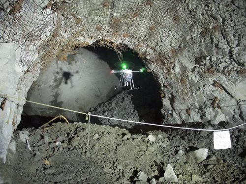 The “plug and play payload” Hovermap, which allows drones to fly underground and in GPS-denied locations, has been released by Data61. Featuring omni-directional LiDAR, the 1.8kg Hovermap is a self-contained unit containing a small processor and a spinning cylinder; its Simultaneous Localization and Mapping capability provides accurate LiDAR operations can be carried out without the use of GPS. The demand for industries to digitize and remotely inspect assets in hazardous areas has prompted five years and more than $3.5 million in venture capital to commercialize the product.
Earth observation becomes mainstream in the UK
Ian Boyd, who heads up science at the Department for the Environment, Food and Rural Affairs in the United Kingdom, announced at a London think tank event recently that the use of earth imagery will become mainstream in the next ten years. The government has thus far been challenged by the rate of change in technology, and unable to keep up; they have also been impeded by finance. Nevertheless, legislation like the 25-Year Environment Plan (containing targets to improve air quality and reduce pollution and climate change) is currently moving through Parliament and would be greatly helped by the kind of data being produced by Planet, a UK company specializing in satellite technology. To that end, Boyd is working with data scientists to investigate how to get data from earth observations to decision-makers quickly in emergency situations.
Dawn of the data-driven supply chain
As more businesses go digital, there is an increasing need for the tools that facilitate the analytics of data. Big data analytics help organizations reduce costs and create more efficient supply chains—and this gives companies a competitive advantage and greater visibility. Machine learning algorithms power a large amount of location-based analysis. The predictive insights of machine learning and location intelligence technology are helping companies capture, store, and manage data, run analysis, and visualize insights. AI, the Internet of Things, and GPS are creating the supply chains of the future. By adopting advanced analytics, businesses are set to deliver better customer experience.
AI enters Indian food delivery industry
Millennials love their food delivery no matter where they are in the world; backing up this fact is Bengaluru-based research firm RedSeer, which expects to see the Indian online food delivery market reach $4 billion by 2020. Food aggregator Swiggy is using AI and machine learning to create a three-way local marketplace where consumer demand is matched with restaurant and delivery partners. AI provides a personalized discover experience, cataloging customer intelligence and real-time signals. According to Zomato CEO Deepinder Goyal (who has acquired a startup called TechEagle Innovations for drone-based food delivery), robots “powering the last-mile delivery is an inevitable part of the future and hence is going to be a significant area of investment for us.”


Be the first to comment