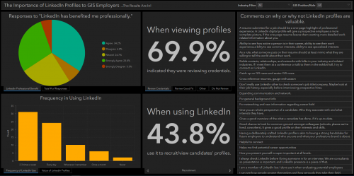
How Important is LinkedIn for Young GIS Professionals?
These days, there are lots of different social media platforms for representing yourself as a job seeker in comparison with the traditional way of resume writing. LinkedIn is one of the modern online resumes. Although it may not always be the best for job hunters to find their employment, It is a great platform for networking and being in a large group of professionals.
As GIS professionals may have different perspectives about the role of LinkedIn in the GIS job market, Vanguard Cabinet URISA has prepared an ArcGIS Dashboard as the results of a Survey123 survey about the importance of LinkedIn in GIS experts’ views.

Florida DOH GIS Data Manager Fired for Refusing to Alter and Censor COVID-19 Public Data
During this pandemic, Florida’s COVID-19 dashboard was a transparent COVID-19 cases, testing and death data resource for researchers, the media and public. However, last week, the architect of this useful dashboard announced her removal from her post which made independent researchers not only angry but worried about government censorship. Also She mentioned as a warning that she does not know what the new team’s intention are for data access.

Three Predictions for the Geospatial Industry by 2025
- Soon remote sensing and Internet of Things will be critical part of integrated decision support systems. Lower-cost sensors and cloud-powered analytics together support continual data collection. Access to data and analytics will be in days and weeks, rather than months and years which is the benefit of the next generation of remote sensing technologies.
- Within the next five years, data scientists who know remote sensing analytics, software infrastructure and tool will be in high demand. This will be the consequence of great need for understanding of the geospatial data collected by new tools like remote sensing combined with Internet of Things.
- Federal beyond-visual-line-of-sight regulations are being loosened, so BVLOS operations could be used for emergency management, persistent monitoring and asset inspections. Also, drones need to be improved to support the new BVLOS applications.
https://www.directionsmag.com/article/9738
Drones for COVID-19 response operations will pave way for use in commercial applications in India
The government of India has realized the importance of technology as drones have now become the most trusted tools to monitor COVID-19 situation in this country. Government Authorization for Relief Using Drones portal is launched to provide conditional exemptions to involved in drone operations’ agencies and make the non-defence use of drones easier. Autonomous and long-range drones’ operation which is essential for drone-based deliveries will be possible by flying drones Beyond Visual Line of Sight (BVLOS) which is still in operational stage in India.
https://www.geospatialworld.net/blogs/drones-for-covid-19-response-operations-will-pave-way-for-use-in-commercial-applications-in-india/


Be the first to comment