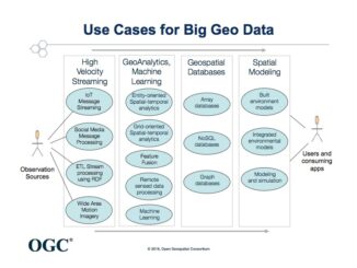
Big geospatial data workshop
The rapid increase of sensing and mobile devices is an unstoppable information source that is transforming human lives in incredible ways. Every two days the human race is now generating as much data as was […]
GoGeomatics Canada would like to announce Peterborough, Ontario has been added to our growing list of cross-country GoGeomatics Socials! We now have 11 groups across Canada. GoGeomatics welcomes Rachel Kuzmich and Danah Ashcroft as the social group […]
Ottawa, August 16, 2016 – The Canadian Institute of Geomatics (CIG), the largest and most influential geospatial knowledge network in Canada, announced the addition of Dr. Brent Hall as Executive Vice President. Brent will be […]
The Geomatics Association of Nova Scotia (GANS) would like to invite you to join us at the Best Western Plus Hotel in Dartmouth on September 27th and 28th for a two day event on the future of […]
The Open Geospatial Consortium (OGC®) has adopted SensorThings API Part 1: Sensing as an official standard. The OGC SensorThings API provides an open, geospatially enabled way to interconnect Internet of Things (IoT) devices, data, and […]
Always at the forefront, the CycleMap application is revolutionising how people plan their bike rides with its RouteMagic, a new and unique feature that, in a matter of seconds, provides customized biking loop path, a […]
Interview with Brent Hall, Director of Education and Research at Esri Canada and, along with his staff, the initiator of Esri Canada’s GIS Ambassador program. Dr. Brent Hall is director of Education and Research at […]
The UK Government’s goal for construction industry is to reduce the CAPEX for public construction projects. To reach its goal for the construction industry the UK Government has undertaken several initiatives, one of which is […]