• facebook
  • Twitter
  • Linkedin
  • Youtube
  • Linkedin Group
  • Post a Job
  • Post an Ad
  • Post an Event
  • Post a Directory Listing
  • Post a Press Release
  • Media Kit
  • My Account
  • Login
GoGeomatics
  • MAGAZINE
    • BIM & GIS
    • Community
    • Conference news
    • Earth Observation
    • Education & Careers
    • GEOAI
    • Announcements
    • Reality Capture & Lidar
    • Science
    • Technology
    • Between the Poles
  • Directories
    • ASSOCIATION
    • INDUSTRY
    • EDUCATION
    • Open Data
  • EVENTS
    • GeoIgnite Events
    • Events Calendar
    • GoGeomatics Meetups
  • Services
    • Advertising
    • Marketing
    • Post a Job
    • Post an Ad
    • Post an Event
    • Post a Press Release
    • Post a Directory Listing
    • Media Kit
    • Web Design
  • Find a Job
  • Volunteer
    • Start a GoGeomatics Group
    • Editors & Writers Group
  • About Us
    • About Us
    • Contact Us
    • Frequently Asked Questions
  • Videos
Home2020June

Month: June 2020

||||
Technology

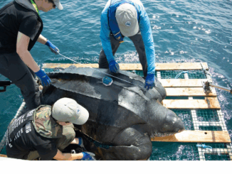
Your Canadian Geospatial Briefing for June 15th: Canadian Drone delivery solution; City of Montreal open data; Tagged leatherback sea turtles; Endangered Fish in BC

15 June 2020 GoGeomatics Canada | api

Drone company will convey COVID-19 medical equipment to First Nation Drone Delivery Canada (DDC) will transport COVID-19 medical products using Sparrow drone to Beausoleil First Nation (BSN) community located at the southern tip of Georgian […]

3D data

Using statistical averaging to increase depth of penetration for ground penetrating radar

10 June 2020 Geoff Zeiss

Recently Greg Johnston of Sensors and Software gave a very informative webinar on the factors that limit the depth to which ground penetrating radar (GPR) is effective in detecting objects.  Greg showed how statistical averaging […]

Surveying Mount Everest|||
Technology

Your International Geospatial Briefing for June 8th: NZ Lego Map; Mapping COVID-19 Stories; Monitoring Lakes with Remote Sensing; Chinese Surveyors Reach Everest; Geospatial Analysis of COVID-19

8 June 2020 GoGeomatics Canada | COVID-19

Data analyst’s incredible NZ Lego map made with 3600 bricks German Alex Waleczek, who lives in New Zealand, made an accurate 3D model of a map of New Zealand. The map is 90cm x 128cm […]

Community

GeoIgnite 2020 Online; Canada’s National Geospatial Leadership Conference: An Interview with Jonathan Murphy

8 June 2020 T Mackinnon | Canada

GeoIgnite Online 2020: The theme for this year is (no surprise): Leadership In Times of Disruption Next month the Canadian geospatial community will gather online for this year’s GeoIgnite 2020.  Join Ted Mackinnon (Member of […]

||||||
Technology

Book Review- Sarah Parcak’s ‘Archaeology from Space’

5 June 2020 Alan D.K. Armstrong | Alan Armstrong

What a great time to be a geospatial specialist. The impact of location technology continues to grow. I am excited the power of thinking “geospatially” continues to enhance every aspect of our lives and work. […]

3D data

White paper on reducing damage to underground utilities during construction

2 June 2020 Geoff Zeiss

It is estimated that unreliable location information about underground infrastructure represents a $50 billion drag on the U.S. economy. Comparing the United States and Japan reveals a startling difference in the annual incidents of underground […]

Newsmakers & Press Releases

Kongsberg Geospatial to use AI and Drones to enhance Search and Rescue Operations in Canada

2 June 2020 GoGeomatics Newsmakers | Canada

Kongsberg Geospatial, developer of the TerraLens Geospatial SDK, and Larus Technologies of Ottawa, Canada, and the Civil Air Search and Rescue Association of Canada (CASARA), announced today that they have been selected by Public Safety […]

|
Technology

Remote Sensing: The Potential Impacts of COVID-19 on Oil & Gas Sector

2 June 2020 Celso Isidro | Canada

The COVID-19 pandemic has impacted various industries globally. Among these industries, the oil and gas sector took a blow while it had been already reeling from the 1999 collapse of the consumer value of oil. […]

Posts pagination

« 1 2 3 4 »

Events

Apr 27
April 27 - April 30

Welcome to the Canadian Hydrographic Conference 2026

May 3
May 3 @ 8:00 am - May 6 @ 5:00 pm

GEOINT Symposium 2026

May 11
May 11 @ 8:00 am - May 13 @ 5:00 pm

GeoIgnite 2026

May 25
May 25 - May 28

National Surveyors’ Conference 2026

May 27
May 27 @ 8:00 am - May 29 @ 5:00 pm

Canadian Cartographic Association Conference 2026

View Calendar

View All Events

Services

  • Post a Job
  • Post an Ad
  • Post an Event
  • Post a Directory Listing
  • Post a Press Release
  • Media Kit
  • My Account
  • Login

Jobs

Post a Job
  • Operations Spatial Data Assistant (Contract)
    Vaughan
  • GIS Analyst
    Saint John, New Brunswick
  • GIS Student Intern
    Elmsdale, Nova Scotia
  • Canada Impact+ Research Chair – Professor (Or Associate Professor)
    Lethbridge, Alberta
View All Jobs
  • Directories
    • Associations Directory
    • Industry Directory
    • Education Programs
    • Open Data
  • Volunteer
    • Start a GoGeomatics Group
    • Editors & Writers Group
  • About Us
    • GoGeomatics Media Kit
    • Who We Are
    • Contact Us
    • FAQ’s
    • Advertising
    • Marketing
  • Subscribe
GoGeomatics
GoGeomatics is the largest and most popular communications hub promoting the Canadian geospatial community. The business was incorporated in 2011. GoGeomatics hosts over 100 fun, free, location technology networking events each year in cities across Canada.

© 2026 GoGeomatics

  • facebook
  • Twitter
  • Linkedin
  • Youtube
  • Linkedin Group