Canadian Geospatial Digest for August 1, 2022
Endangered BC Heritage Site Digitally Preserved by University Professors
Edelweiss Village, a heritage site in British Columbia (BC), is the birthplace of mountaineering culture in Canada. The village is being sold for $2.3 million.
The Canadian Pacific Railway (CPR) brought in Swiss mountain guides to the Rockies to encourage tourism and share their knowledge. The guides stayed at Edelweiss so they could teach Canadians mountaineering.
University of Calgary professors are currently digitally preserving the site of six chalets on 20 hectares north of Golden, BC. The professors are working to preserve the site so it doesn’t get lost as time goes by or is sold. Due to the village’s location, the potential buyers won’t be required to preserve the chalets.

photo from Vancouverisawesome.com
Terrestrial laser scanners are used by a team to capture data and virtually recreate the stie to be publicly accessible online.
The Digital Heritage Archive gets involved in sites such as Edelweiss even if there is no official designation. Public awareness is important, and having the site digitally preserved makes the site accessible to more people. Virtual tours are also created for the public.
There is still hope the site will be purchased by an organization that will physically preserve the site.
https://www.cbc.ca/news/canada/calgary/edelweiss-village-preservation-1.6526914
Canada’s Map of Fracking-Induced Earthquakes is Now Available
A new map has been developed to help the public understand and even predict where earthquakes due to energy extraction will take place.
The map, developed by University of Waterloo scientists, shows population centres and regions of western Canada that are likely to have fracking-induced earthquakes.
Hydraulic fracturing creates cracks in rock formations during geothermal and other types of energy extraction. These processes often induce earthquakes.

photo from phys.org
There is a case study of western Alberta and northeast BC that is important because of the large natural gas and petroleum reserves. Communities in these areas have experienced the largest fracking-induced earthquakes in the world, with many occurring near Fort St. John, BC.
In the future, this map will be used as a baseline when dealing with underground energy extraction and fluid injection projects.
https://uwaterloo.ca/news/media/new-map-shows-where-fracking-induced-earthquakes-could-hit
Interactive Map Begins Nova Scotia’s Property Use Conversation
Nova Scotia’s (NS) housing crisis became part of the conversation because of an interactive map.
The map shows empty or vacant buildings and spaces in Nova Scotia, causing inhabitants to think about the current housing crisis. It can be used for record keeping, as well as a tool of accountability for all three levels of government.
Lorax Horne and Halifax Mutual Aid worked together to create the map called “This Should Be Housing.” Anyone can add spots for housing to the program. There are 900 spots currently on the interactive map.

photo from thisshouldbehousing.com
Affordable Housing Association of Nova Scotia (AHANS) strongly supports this initiative. Nova Scotia needs to build 50,000 units by 2030 to fulfill demand. This can only happen if public assets are observed. AHANS acquired over 100 units during Covid to protect tenants from renoviction.
There are currently 5950 applicants on the waiting list, and the wait time for housing is about two years.
https://globalnews.ca/news/8984691/nova-scotia-interactive-map-property-use-housing-crisis/
HDR Awarded Esri’s GIS Special Achievement Award
HDR’s work on the Ontario LIne Subway Program was recognized with the Special Achievement Award in GIS (Geographical Information System) by Esri, for delivering better services by effective use of GIS.
Esri is a global leader in mapping, location intelligence, and GIS software. Every year, Esri awards projects or clients that set precedents in the GIS community.

photo from hdrinc.com
Ontario Line is a rapid transit line with a proposed 15 stations, running about 10 miles throughout Toronto. This project has HDR as the technical advisor. GIS and BIM are to be integrated into the project with CAD, so there is no need for duplication of information.
Esri’s ArcGIS Hub was used by HDR to develop a planning portal. It he.ps the 1000 member team to review utilities, properties, 2D alignments, 3D station designs, and environment impacts and much more.
Among High Temperature Warnings, Victoria Takes Action
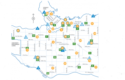
Victoria, British Columbia (BC), opened 14 misting stations to manage heat waves recently. Temperatures of 29 C are expected, with higher temperatures (35 C) in areas farther away from the water.
The misting stations are open Monday through Thursday, and during the daytime hours.
There is a misting station interactive map available that allows the public to locate a station near their location. A map of cooling centres, water parks and other community assets is also available.

photo from vancouverpublicspace.ca
The city wants residents to prepare for the heat and even check on those people they know who may have a hard time in the high temperatures. The city is giving tips like drink water often, know where the misting stations are, and a variety of other tips.
https://www.google.com/amp/s/beta.ctvnews.ca/local/vancouver-island/2022/7/25/1_6001725.amp.html


