Canada is Moving in 2025 – Canada’s New Reference Frame NATRF2022
As GPS technology constantly evolves and the North American continent deforms, a modernization of our geodetic reference frames to accurately meet these needs is under way. Through GoGeomatics LiDAR CANEX, Calvin Klatt, the director of the Canadian Geodetic Survey (CGS) highlighted the importance of this reference frame modernization, its activities around this and how Canada is integrating with the United States.
By sharing one of the longest borders on Earth, there is a need for Canadian and the United States’ reference frames to be compatible. Offsets of 1.3m to 1.5m will exist along the border as the US moves towards the North American Terrestrial Reference Frame if 2022 (NATRF2022). To avoid this, the Canadian Geodetic Survey has been working with the United States’ National Geodetic Survey to define and realize NATRF2022 and develop plans to adopt it in Canada as well.

Figure 1: Potential horizontal offsets scenario
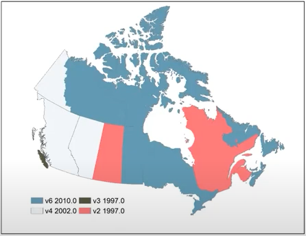
With the aim of being a continent wide refence frame, the Canadian Geodetic Survey has taken this opportunity to move Canadian provincial and municipalities to NATRF2022 from a wide variety of reference frames. Some of these include various versions and epochs of NAD83(CSRS) and locally used legacy frames such as Toronto-NAD27. However, as transforming epochs introduces a level of uncertainty depending on the epoch, the CGS is working with provinces and municipalities to mitigate these errors. In addition, adoption of frames is a provincial responsibility.

Figure 2: Various NAD83(CSRS) epochs across Canada
Through these modernization efforts, a new realization of CGVD2013 will be released using an updated the same geoid model. However, the United States’ vertical datum, NAVD88 will be replaced with the North American-Pacific Geopotential Datum of 2022 which will be a geoid-based datum instead of a leveling based one. In addition, NAPGD2022 will be the same as Canada’s CGVD2013 which will reach the goal of having consistent frames throughout North America.
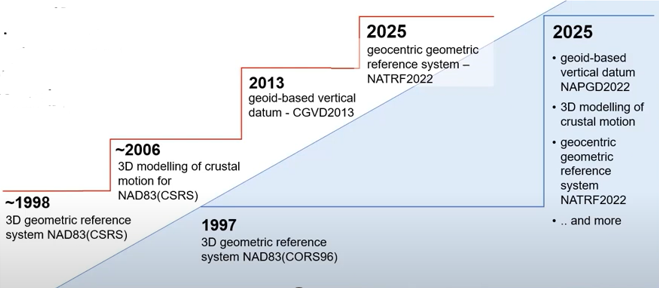
While the goal of sharing a consistent frame between the 2 countries was the same, efforts to reach the goal were different. The United States took a big effort to modernize all at once while Canada took steps since 1998 with the introduction of NAD83(CSRS) which was a 3D geometric reference system followed by 3D modelling of crustal motion in 2006, a geoid based vertical datum in 2013 and finally a geocentric geometric reference system (NATRF2022) by 2025.

Figure 3: Canada and USA’s modernization efforts
As moving towards a new frame is a process, legacy versions of NAD83(CSRS) will be supported as well. These will be reflected in coordinates of survey control, Precise Point Positioning (PPP) results being provided in both NAD83(CSRS) and NATRF2022.
The introduction of a similar reference frame between Canada and the United States highlights the century old efforts of collaboration between the Canadian Geodetic Survey and the National Geodetic Survey.
References
GoGeomatics Canada. (2023, April 27). Positioning Lidar & the Canadian Geospatial Industry for the Future | LiDAR CANEX 2023 [Video]. YouTube. https://www.youtube.com/watch?v=Ot-LDzN2MS0
Natural Resources Canada. Mind the Gap! A new positioning reference – NATRF2022. Natural Resoruces Canada, 2020. https://cgrsc.ca/publications/NATRF2022-reference%20pamphlet.pdf


