

Canadian Geospatial Digest for August 12, 2024
- Jasper officials publish a map and detailed list of all structures lost in the wildfire
- Flash floods threaten as severe landslide creates new risks near Chilcotin River
- Canada signs an agreement to utilize US space technology, paving the path for a rocket launch site in Nova Scotia
- Google Maps Launches Immersive View in Five Canadian Cities for Virtual Exploration
- Wildfires in British Columbia in 2024: A live map displaying fire locations and evacuations
- Deep ocean wonders and losses: the future of its waters
Jasper officials published a map and detailed list of all structures lost in the wildfire
A huge wildfire in Jasper, Alberta destroyed about a third of its structures including over 350 mostly residential houses. Parks Canada together with local authorities released maps and a list of damaged properties. This wildfire is the largest ever recorded in Jasper National Park for over a century, leaving thousands of people to escape and different parts of the town in shambles. Different activities are currently being done to evaluate the losses incurred as well as combating the remaining flames; there is also military support available. It will take some time before recovery can happen and some officials are organizing bus tours for those who were evacuated to see the destruction live. Follow the link to read the whole story.
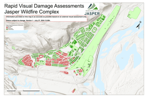
Jasper wildfire complex, Source: CBC
Flash floods threaten as severe landslide creates new risks near Chilcotin river
A landslide blocked the Chilcotin River in British Columbia, forming a dam 30 meters high and 600 meters wide on July 30, 2024. By August 5, the dam was breached, leading to significant flood warnings and evacuation orders for areas along both the Chilcotin and Fraser rivers. The breach created a 15-meter-wide channel and raised water levels, with potential for severe downstream flooding. Authorities are closely monitoring the situation with technical assessments and remote sensing. Residents are advised to avoid riverbanks and prepare for possible further developments. Read the full article here. For updates, visit the Chilcotin River Landslide Information Portal.
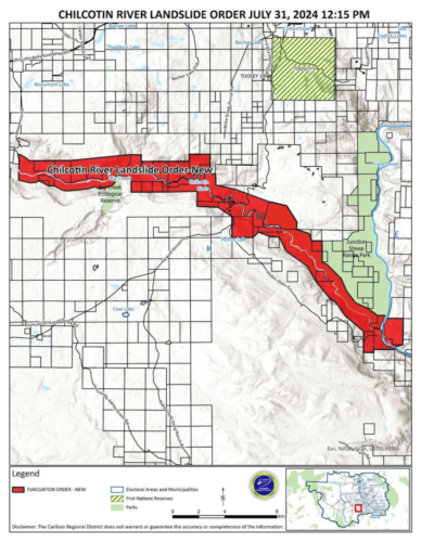
Landslide across the Chilcotin River, Source: thetyee
Canada signs an agreement to utilize US space technology, paving the path for a rocket launch site in Nova Scotia
An agreement between the United States and Canada permits the use of American space launch technology within Canada, opening the door for the development of a spaceport in Nova Scotia. The Technology Safeguards Agreement, which was announced by Federal Minister Sean Fraser, needs final clearances but should move forward quickly. After difficulties in the delivery of rockets from Ukraine, Maritime Launch Services, headed by Steve Matier, is getting ready to construct a launch pad in Canso, Newfoundland, using a new type. Though it was scaled back to $50 million, the proposal has generated criticism locally despite its potential economic advantages. Check out the article here.
Google Maps Launches Immersive View in Five Canadian Cities for Virtual Exploration
Users in Canada can now digitally tour Montreal, Calgary, Toronto, Ottawa, and Edmonton thanks to Google Maps’ Immersive View feature. This tool creates intricate, interactive experiences by fusing cutting-edge AI with Street View and aerial photography. Now, users can virtually fly over famous locations, explore neighbourhoods, and see crowd density data in real time. You may use your tablet, for instance, to tour Old Montreal or the CN Tower in Toronto. Use Google Maps to choose the location you want to explore, then click the Immersive View preview to get access to the feature. The goal of this invention is to improve local exploring and trip planning. Collect more details here.
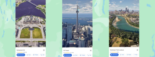
Immersive View in Canadian Cities, Source: Google Canada Blog
Wildfires in British Columbia in 2024: A live map displaying fire locations and evacuations
In 2024, British Columbia will have a difficult wildfire season. An interactive map provided by the BC Wildfire Service displays the locations, boundaries, and current conditions of wildfires around the province. Red triangles indicate evacuation orders, while orange triangles indicate evacuation alerts. Additionally, colour-coded circles on the map show whether flames are under control (green), being held (yellow), or out of control (orange). Important fires are shown by red outlines; these fires frequently combine to form bigger clusters. Residents can view the live map provided by the BC Wildfire Service for updates. Read more here.
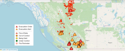
Wildfires in B.C. 2024, Source: Global news
Deep ocean wonders and losses: the future of its waters
Earth’s surface is about 70% covered by deep ocean which remains mostly unexplored and poorly understood. The deep-sea ecosystem is full of strange and unique life forms that are able to survive under extreme conditions in the twilight zone or hadal zone. Recent technological developments like ROVs and high-resolution mapping techniques have led to amazing discoveries such as previously unknown hydrothermal vents or new species. On the other hand, however, deep-sea mining threatens these vulnerable habitats. Supporters of this activity claim that it is necessary for acquiring essential minerals while contrarily detractors warn about severe yet unknown possible ecological consequences. Read more information here.