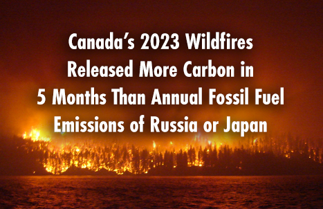

Canada’s 2023 Wildfires Released More Carbon in 5 Months Than Annual Fossil Fuel Emissions of Russia or Japan

NOAA Geocolor satellite image loop of smoke plume over the Northeastern United States. Dark grey/brown area near center is smoke; light grey/white areas north and south are clouds
We know Canada experienced its most destructive wildfire season ever in 2023, which single handedly drove a nearly a quarter of increase in the loss of the world’s tree cover.
And now a new NASA funded study has found that Canada’s wildfires released more carbon in just five months in 2023 than Russia or Japan emitted from fossil fuels in all of 2022.
The fires released around 640 million metric tons of carbon, surpassing Russia’s 2022 fossil fuel emissions of 480 million metric tons and Japan’s 291 million metric tons. However, scientists stress a key difference between the carbon from wildfires and fossil fuels: while CO2 from wildfires can be reabsorbed as forests regrow, the CO2 from fossil fuels remains in the atmosphere without a natural offset.
The 2023 fires in Canada consumed a total of 16.5 million hectares—more than double the previous record and nearly seven times more than the historical average, according to Natural Resources Canada.
The smoke plumes stretched across the Northern Hemisphere, darkening skies and triggering air quality alerts as far away as the United States and Europe.
The study, published on August 28 in Nature, was led by scientists at NASA’s Jet Propulsion Laboratory in Southern California. The research team used observations primarily from the European Space Agency’s TROPOspheric Monitoring Instrument (TROPOMI), aboard the Sentinel 5P satellite and advanced computing to quantify the carbon emissions of the fires.
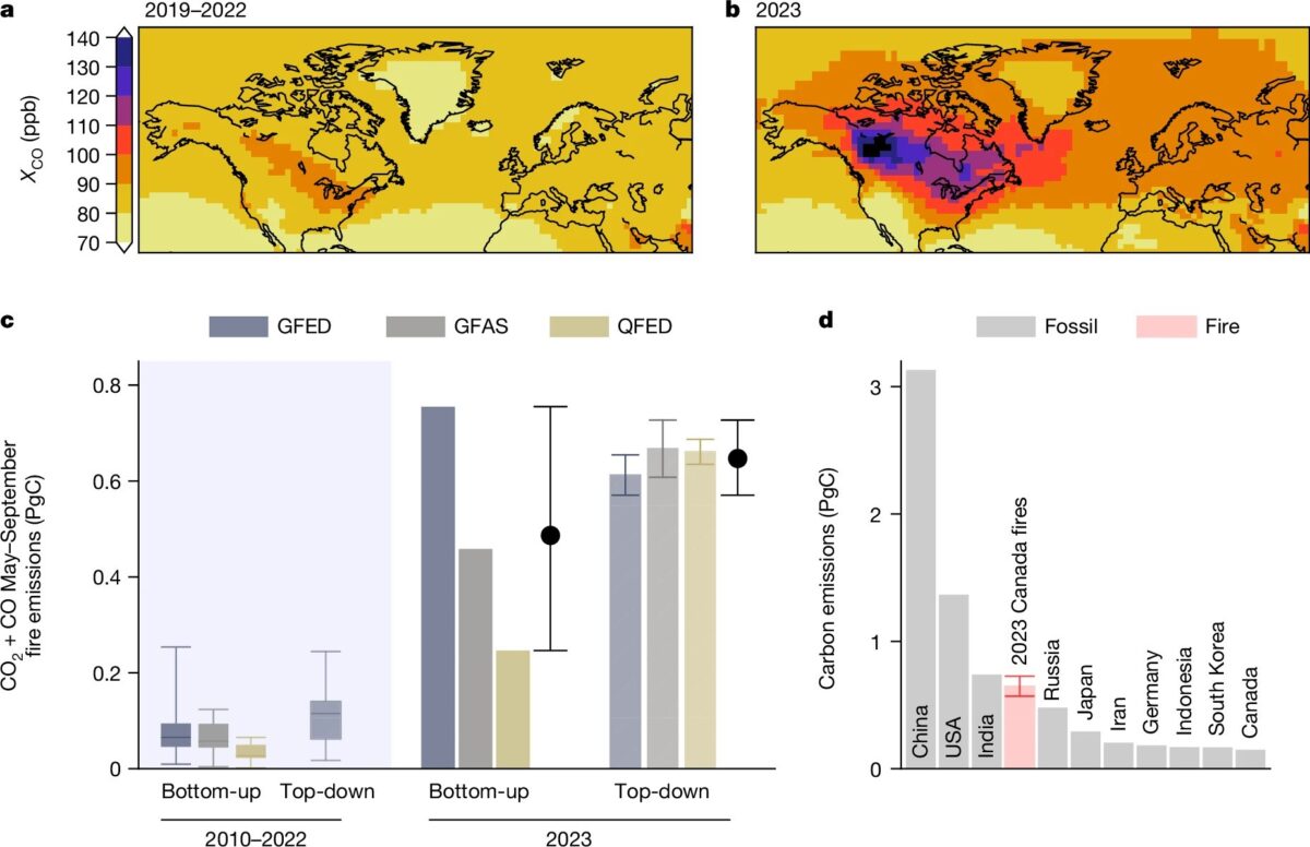
Image courtesy of NASA JPL
TROPOMI’s data has been crucial for tracking these plumes and understanding their impact on air quality. Equipped with four spectrometers, the instrument can detect pollutants in the atmosphere at high resolution, helping scientists and policymakers assess the health risks posed by wildfire smoke.
The fires burned an area roughly the size of North Dakota from May to September 2023, and TROPOMI’s data revealed the extent of the disaster, measuring the trace gases and fine particles released into the atmosphere by the fires. The researchers began by examining the levels of carbon monoxide (CO) in the atmosphere during the fire season. From there, they back-calculated the total emissions that produced those CO levels and used the ratio between CO and CO2 in the plumes to estimate the overall carbon emissions.
Wildfires and a Changing Climate
Forest fires in Canada are intensifying as the country warms twice as fast as the global average rate, with Arctic regions warming nearly three times faster. This overheating climate is leading to drier, hotter, and windier summers, with increasingly unpredictable rainfall and less summer precipitation in certain areas. Fire seasons are now starting earlier, lasting longer, and becoming more difficult to control.
And as the summer draws to a close, the 2024 wildfire season in Canada is again emerging as one of the most destructive in recent years. Although less severe than the catastrophic fires of 2023, it still ranks among the top six seasons of the past 50 years.
The NASA JPL team found that between May and September 2023, temperatures in northwestern Canada, where 61% of the fire emissions occurred, were over 4.5°F (2.6°C) above the historical average. At the same time, rainfall was 3 inches (8 centimeters) below normal levels. The conditions set the stage for the fires to grow to extraordinary sizes, burning across 18 million hectares of forest from British Columbia in the west to Quebec and the Atlantic provinces in the east.
The damage was staggering: the area burned in 2023 was over eight times larger than the 40-year average, consuming about 5% of Canada’s forests. According to the Canadian Interagency Forest Fire Centre, the area burned in 2023 was also more than six times the historical average.
A report from the World Resources Institute earlier this year highlighted that the 24% rise in global tree cover loss in 2023 was mainly driven by fire-related destruction in Canada’s boreal forests. The surge in wildfires was the key factor behind the increase from 22.8 million hectares of tree cover loss in 2022 to 28.3 million hectares in 2023.
If these conditions continue, they could have far-reaching consequences for Canada’s forests and the global climate.
Implications on Global Climate
The fires also raise concerns about the future role of Canada’s forests in combating climate change. Canada’s forests are considered a major carbon sink—ecosystems that absorb more CO2 from the atmosphere than they release, and increasing fire activity could undermine this capacity.
If large-scale fires become a more common occurrence, the carbon released from burned forests could offset the gains made by reforestation and afforestation efforts. This could diminish the forests’ overall ability to slow climate change. While regrowing forests do eventually absorb some of the carbon they lost, the intensity and frequency of future fires could mean that these ecosystems will release more carbon than they capture.
Fire Management Under Scrutiny
The 2023 fire season also put the spotlight on fire management strategies in Canada and globally. Traditional approaches have often focused on extinguishing wildfires as quickly as possible, but some experts argue that this has left many forests overly dense with undergrowth—fuel that can make wildfires burn hotter and spread faster.
The situation in Canada is part of a broader global trend. Wildfires have been intensifying around the world, from Australia to the Mediterranean, often in places that are experiencing hotter and drier conditions linked to climate change. As wildfires become more extreme, their impact on air quality is also becoming a major concern.
At the same time, adapting fire management strategies to the new reality of more frequent and severe wildfires will be key to safeguarding communities and ecosystems.
Earlier this year, the Canadian Safety and Security Program (CSSP) announced a call for proposals under the ‘S&T Challenge: Wildfire Firefighting Common Operating Picture.’ This initiative aims to enhance wildfire management by integrating satellite data, propagation models, and resource information into a unified system. Currently, wildfire intelligence in Canada is often fragmented and delivered through various tools and software, leading to confusion and inefficiencies.
Additionally, the Canadian Space Agency announced last year its plan to launch WildFireSat, the world’s first dedicated public fire-monitoring satellite. This satellite will enhance Canada’s wildfire management capabilities by providing daily, comprehensive monitoring of all active wildfires from space. This new satellite will complement existing fire data sources, which include key instruments aboard the European Space Agency’s Sentinel satellites, infrared sensors from the U.S. National Oceanic and Atmospheric Administration (NOAA), and high-resolution photographs from NASA’s Aqua and Terra satellites’ Moderate Resolution Imaging Spectroradiometers (MODIS).