Significant increase in lidar-derived elevation data coverage
The National Elevation Data Strategy team has increased its production rate. Detailed 3D products now cover 49% more area since the last newsletter in November 2023. Here are the changes to the four main elevation products.
High Resolution Digital Elevation Model products
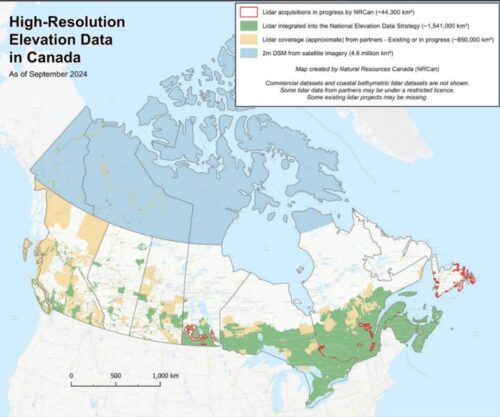
Since November 2023, more than 507,000 km² of lidar data have been integrated into the High Resolution Digital Elevation Model (HRDEM) and HRDEM Mosaic products. To date, the complete coverage represents 1.54 million km² and approximately 93% of the population lives in areas covered by both products.
Automatically Extracted Buildings
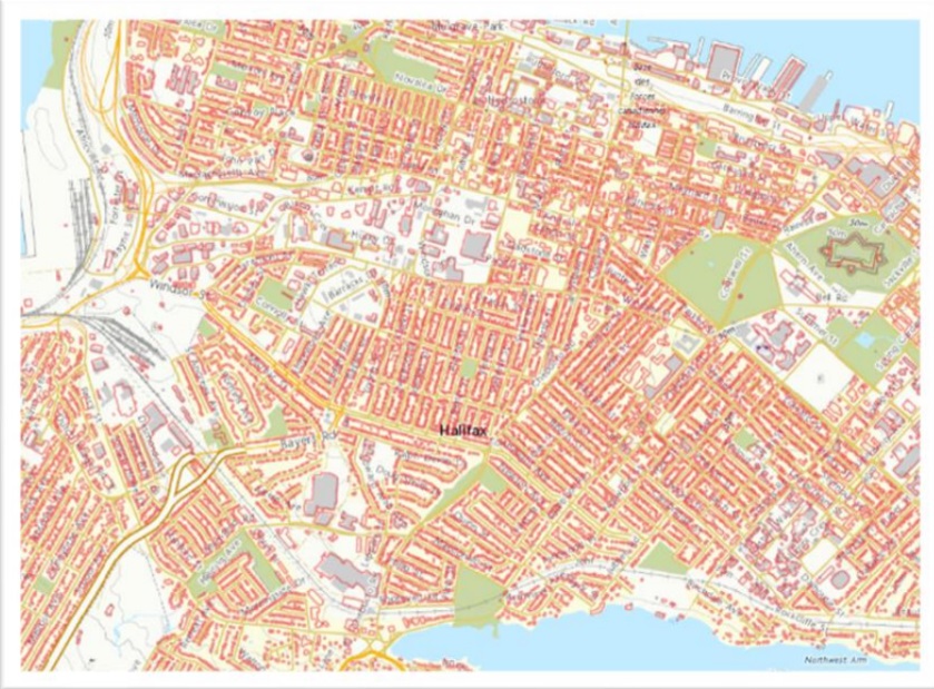
Over 95% of building footprints in Nova Scotia are now available on Open Government. Courtesy: NRCan
More than 2.8 million new lidar-derived building footprints have been added to the Automatically Extracted Buildings product since November 2023, for a total of over 12.4 million footprints. These footprints are located in the provinces of Nova Scotia, New Brunswick, Quebec, Ontario, Manitoba, Saskatchewan and British Columbia. These additions include sixteen of Canada’s 100 largest cities: Sydney, Fredericton, Gatineau, Halifax, Lindsay, Quebec City, Trois-Rivières, Saskatoon, Ajax, Caledon, Markham, Pickering, Richmond Hill, Toronto, Vaughan and Kingston.
Lidar Point Clouds
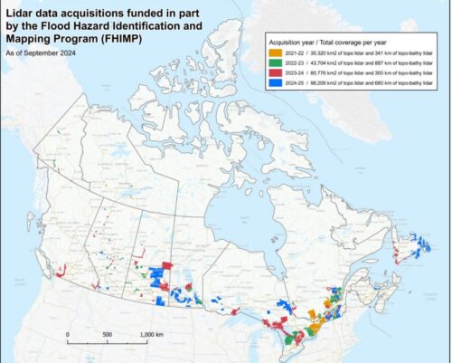
Since November 2023, more than 92,400 km² of new lidar point cloud data have been published, for a total of 222,400 km². These additions cover regions in British Columbia, Alberta, Saskatchewan, Manitoba, Ontario, Quebec, Nova Scotia and Prince Edward Island. The latest publications include lidar projects acquired with funds from the Flood Hazard Identification and Mapping Program (FHIMP), including acquisition contracts managed by Natural Resources Canada (NRCan).
The lidar data used in the various products is provided from numerous partners across the country, as well as from acquisition projects carried out by NRCan, notably from funding from the FHIMP.
New nationwide medium-resolution elevation product available
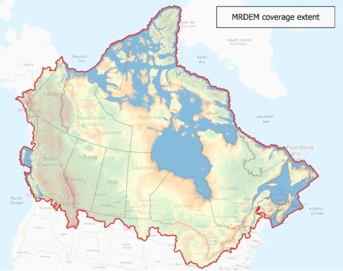
MRDEM Coverage extent
For years, users have relied on the Canadian Digital Elevation Model (CDEM) and the Canadian Digital surface model (CDSM) for medium resolution elevation data. A new chapter begins with the Medium Resolution DEM (MRDEM)! This new product, part of the CanElevation Series, includes aligned Digital Surface Model (DSM) and Digital Terrain Model (DTM). The MRDEM represents a significant update over its predecessor.
It incorporates more recent and accurate elevation data from the Copernicus Digital Elevation Model (GLO-30) and lidar-derived HRDEM at a 30 meters resolution. Integrating these data ensures that the MRDEM better reflects recent natural and human-caused changes in Canada’s landscape.
The DTM of the MRDEM was created using an innovative approach. Where available, the HRDEM Mosaic derived from lidar was used and resampled from 1 m to 30 m. Elsewhere, the processing workflow combines a forest removal model and a settlement removal model that is applied to the GLO-30 values to estimate the terrain elevation values.A filtering and blending process is applied to create a more seamless transition between the two terrain models. As for the DSM, it is essentially derived from GLO-30. The entire dataset was horizontally reprojected to NAD83(CSRS) Canada Atlas Lambert, and vertically transformed to CGVD2013 which is the reference standard for heights across Canada.
This new product, part of the CanElevation Series, provides comprehensive coverage across Canada and is now the best nationwide medium resolution elevation model publicly available for Canada. The product coverage also slightly extends to the US, where needed, to provide coverage for cross-border watersheds in support of hydrological studies and applications.
Overall, the MRDEM is a great asset for large-scale elevation-based analysis. Explore its potential and benefits!
2024 lidar acquisitions in support of the Flood Hazard Identification and Mapping Program
When it comes to understanding and managing flood risk, accurate topographic data is essential. Lidar data provides a detailed and accurate representation of landforms and areas at risk, offering reliable data for flood modelling, the creation of flood hazard maps and flood management decision-making. Since the beginning of the Flood Hazard Identification and Mapping Program (FHIMP), NRCan and the provinces and territories have been working closely together to acquire this valuable data in flood-prone regions and watersheds.
Under FHIMP, 17 lidar acquisition projects are underway for 2024, for an additional coverage of around 98,000 km². With this addition, a total of 59 lidar acquisition projects will have received funding from the program in 4 years, for a total coverage of 253,000 km² (see image below).
All this data is progressively integrated into the National Elevation Data Strategy products.
Migration of the Federal airborne lidar data acquisition guideline into a National Standard of Canada
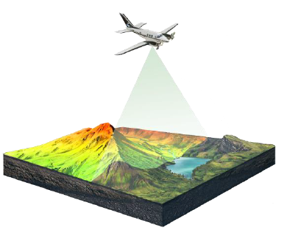 The Federal airborne lidar data acquisition guideline, part of the Federal Flood Mapping Guidelines Series, is an important guide for the acquisition of base elevation data from airborne lidar data undertaken across Canada. It provides stakeholders context, explanations and technical specifications required to plan an airborne lidar data acquisition. Over the last few years, the guideline was updated several times based on guidance from the lidar acquisition experts for multiple domains, from dense urban mapping to applications for enhanced forest inventories, flood mapping and topo-bathymetric lidar mapping.
On a parallel path, NRCan, Public Safety Canada and the Standards Council of Canada have been working on efforts towards the standardization of the Federal Flood Mapping Guidelines Series, with the objective of initiating a long-term project to strengthen flood mapping practices, contributing to safer and more resilient communities across Canada. In various workshops held over the last few years, discussions revealed a strong, cross-sectoral desire to move towards standardization of the Guidelines Series, as well as an awareness of the challenges ahead.
Fast forward to spring 2023, the CSA group, on behalf of the Standards Council of Canada, started the initial development of National Standards of Canada based on both the Federal airborne lidardata acquisition guideline and the Federal geomatics guidelines for flood mapping. NRCan is supervising these activities by chairing both the technical committee responsible for overseeing the development of the two standards, as well as the technical subcommittee responsible for the lidar standard development. The content development phase occurred between fall 2023 and summer 2024, when two groups of experts from various levels of government, academia and the private sector iterated on drafts of the standards. The lidar standard underwent a public review between August 22 and October 21, 2024. Barring any major issue, should enter final production early in 2025, and be available (and free to download) in spring 2025.
On the technical side, the content has been given a thorough refresh. It includes a new density and accuracy-level system for acquisition specifications. The topo-bathymetric lidar appendix was thoroughly updated to reflect the experience gained from several years of inland river collections in Canada. Most of the changes suggested in the newest ASPRS Positional Accuracy Standards for Geospatial Data, Edition 2, Version 2.0, including major changes to accuracy measurement assessment and reporting, have been integrated as well.
This standard will provide nationally vetted guidance and specifications on the collection of airborne lidar data. Once published, capacity-building activities will be planned to support the uptake and implementation of the new national standard.
Regional Modelling for Increased Flood Mapping Coverage supported by the Elevation Data
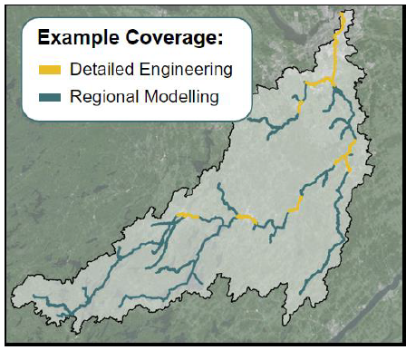 As FHIMP continues to work on developing detailed flood hazard maps for higher risk areas, NRCan has partnered with the companies KGS and DHI to develop technical recommendations and conduct pilot projects for regional flood modelling and mapping. This initiative strives to develop cost-effective flood hazard information at a regional scale (upwards of 5,000 km² or at the watershed/sub-watershed scale) with confidence greater than global or national models, and where detailed engineering maps may not be suitable (due to cost or reduced risk).
The methodology will use the best available input data such as the High Resolution Digital Elevation Model (HRDEM), where available, as well as advancements in Artificial Intelligence (AI) and model simplifications supported by engineering best practices to develop flood hazard information at this regional scale.
NRCan’s National Elevation Data Strategy supports the development of regional models through its data acquisitions, targeting large acquisitions of key watersheds in Canada and providing crucial inputs into the modelling process such as digital elevation models, building layers, and even lidar point clouds to support the estimates of bathymetric information.
Technical documentation and results from the pilot studies are under development and will be made available to Canadians in the coming year as work is finalized. For general inquiries, please reach out to geoinfo@nrcan-rncan.gc.ca or visit our website—FHIMP.
The authors
David Bélanger
Guillaume Légaré-Couture
Heather McGrath
Jean-Sébastien Moreau
Charles Papasodoro
Brian Perry
Baba-Serges Zango


