
Introduction
AI is everywhere. ChatGPT, Google Gemini, and Claude—names that barely existed in the public vocabulary a few years ago—now dominate headlines, boardrooms, and stock markets. But there’s another term quietly building the same kind of momentum: critical minerals. These minerals are becoming essential to both the modern economy and national security.
Lithium, cobalt, nickel, graphite, and rare earth elements power everything from smartphones and electric vehicle batteries to advanced defence systems.
Lose access to them, and supply chains across numerous industries begin to break down.
Demand isn’t just growing; it’s projected to triple by 2040. Canada is moving to capitalize on this opportunity by fast-tracking critical mineral development, aiming to build more resilient supply chains, advance climate goals, strengthen national defence, and unlock one of the world’s largest untapped mineral reserves.
The technologies making this possible are a combination of geoscience, geospatial data, and artificial intelligence that are helping map and better understand the wealth buried beneath Canadian soil.
The Rise of Digital Geology
Geology and mining have entered a new era of digitization. Modern platforms combine data from diverse sources into accessible 3D environments, allowing faster and more comprehensive assessments of rock and mineral composition.
Reading Drill Cores Using Hyperspectral Imaging
Drill cores are solid cylindrical samples of rock extracted from beneath the Earth’s surface that provide geologists with a vertical record of subsurface geology. Hyperspectral imaging is changing how these samples are analyzed. As a non-destructive remote sensing technique, it captures hundreds of narrow, contiguous bands of reflected light across the electromagnetic spectrum.
The detailed spectral resolution allows geologists to identify minerals and materials based on their unique spectral signatures. By mapping these signatures, they can determine mineral composition, detect alteration zones, and identify areas that may contain critical mineral deposits more efficiently than with traditional methods alone.
Canadian Digital Core Library (CDCL)
Canada has approximately four million metres of archived drill core stored across five provinces—enough rock, laid end-to-end, to almost span the entire country.
The Canadian Digital Core Library (CDCL) aims to change that. It is a national platform, developed in partnership with the provinces and territories, designed to give researchers, companies, and investors access to digitized drill core data from across the country. Natural Resources Canada has committed up to $40 million over two years, from 2026 to 2027, to build it.
The benefits go beyond convenience. Once operational, the platform is expected to improve data accessibility and reduce exploration risk, accelerating investment across Canada’s mining sector while supporting the country’s broader National AI Strategy.
In short, better data leads to faster, more informed decisions about where to explore—and where not to. For an industry long defined by scattered physical archives, the CDCL represents a significant shift toward searchable, AI-ready geological information.
Smarter Exploration Through GIS Technology
If hyperspectral imaging tells geologists what a rock is made of, geospatial technology helps explain where it fits within the broader landscape of terrain, infrastructure, and natural resources.
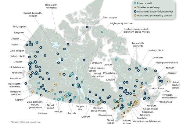
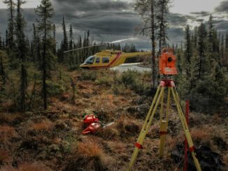
Source: Government of Canada
Advanced GIS tools support more precise data collection, real-time monitoring, and safer mining operations.
By combining geological data, satellite imagery, topographic maps, and other geospatial datasets into a single environment, exploration teams can identify areas with higher mineral potential, reducing exploration costs, minimizing risk, and improving success rates.
GIS also supports 3D geological modelling, allowing companies to simulate extraction methods and visualize the exploration process before operations begin. This improves planning, enhances understanding of subsurface conditions, and helps reduce disruption and waste throughout mining operations.
Beyond exploration, mapping sensitive environmental features—such as water sources, protected habitats, and ecologically fragile areas—helps mining companies better manage environmental impacts throughout the project lifecycle.
Once operations conclude, GIS continues to provide value by supporting reclamation monitoring. Using remote sensing and geospatial analysis, companies can track land restoration over time and assess whether disturbed ecosystems are recovering as intended.
Together, these capabilities contribute to more sustainable mining practices and stronger environmental stewardship.
How GeoAI is Rewriting the Rules of Mineral Exploration
With the emergence of a new generation of GeoAI algorithms, geospatial analysis is becoming increasingly predictive and data driven.
The global race for critical minerals is forcing the mining sector to explore deeper and make decisions more quickly than ever before.
By analyzing vast, multi-layered datasets, GeoAI models can detect subtle spatial anomalies and geochemical patterns that may indicate buried mineralization—patterns that are often difficult for the human eye to recognize.
When combined with high-resolution multispectral and hyperspectral satellite imagery, GeoAI can rapidly identify surface features and chemical signatures across large geographic areas, helping geologists prioritize exploration targets.
The technology also integrates historical borehole records with current geospatial datasets to improve geological models and better predict the location and geometry of potential ore bodies.
Instead of relying solely on static geological maps, mining engineers can work with evolving digital twins of a deposit that are updated as new information becomes available, supporting more informed operational decisions throughout the mining lifecycle.
Ultimately, the combination of artificial intelligence and geospatial data science offers three significant advantages:
- Precision Targeting: Moving exploration from high-risk test drilling toward more data-driven decision making.
- Living Digital Twins: Replacing static geological maps with continuously updated 3D geological models.
- A Smaller Environmental Footprint: Reducing unnecessary exploratory drilling while improving exploration efficiency.
Looking Ahead
The transition to a low-carbon economy will significantly increase demand for critical minerals, making geological intelligence an increasingly important part of Canada’s future. By integrating advanced geological data, digital mapping, GIS, and artificial intelligence into exploration and decision-making, Canada can develop its mineral resources more responsibly and sustainably.
Ultimately, building a resilient future above ground begins with understanding the geology beneath our feet.

Be the first to comment