
Positional continuity, precise and traceable time, testing and simulation—key elements of multi-layered alternate PNT solutions.
What is Alt PNT? What are the key types of solutions in place or in development?
Our work and daily lives are becoming more dependent on geospatial, digital connectivity and remote collaboration. And all of this is heavily dependent on the positioning, navigation, and timing (PNT) that GPS/GNSS* provides. This dependence, perhaps over-dependence, represents a key vulnerability. Alternatives and backup solutions are being rapidly developed and deployed—even in some cases mandated—for critical applications, industries, and infrastructure.
As a follow-up to our April 18, 2021 feature “Progress in Addressing GPS/GNSS Vulnerabilities” where we examined the vulnerabilities, but also the positive steps being made to proactively solve the issues, we offer this, the third installment of a series where we explore Alt PNT technologies and the present work of developers and solution providers.
Contemplating the Unthinkable
For most people, when thinking about the potential impacts of GNSS outages, it is the disruption to navigation that immediately comes to mind. Obviously, consumer navigation and location-based commerce apps are the most commonly recognized end-user manifestations of the technology: “The GPS on my phone is not working”. But what is not widely recognized is that an outage of GNSS would affect many other apps on that same phone, its connection not the cloud, and the cellular networks they rely on for connectivity. Our wired world relies on the delivery of precise time that GNSS provides. Computing networks, cellular networks, IoT, the cloud… through time synchronization these have reached the dizzying levels of enhanced performance that we have become accustomed to, and reliant on.
Professionals in recently highly digitalized fields, like geomatics, 4D construction, engineering design, mapping, etc. are now profoundly reliant on ubiquitous and relatively inexpensive precise positioning and anywhere-computing. For instance, you set off to do a topographic survey of a field for engineering design in a period where GNSS is compromised and there is no opportunity to use the GNSS instrument (rover) to set project control or collect points (or static data for post-processing).
You might also lose your connection to the internet. Your drone flight planning app would not work, and you will not be able to process the images or LiDAR in the cloud. And even if you have standalone software, you might not be able to validate your license online. And on top of that, if there was a widespread GNSS outage, the civil aviation authorities would likely restrict any non-essential (and drone) flights. This only scratches the surface of the potential impacts of GNSS unavailability, or degradation.
Such scenarios are being thought out across many professions and industries. Without precise time, many efficiencies we take for granted would take a substantial hit, if not stopped in their tracks. This reliance across modern economies is the key vulnerability that the specifiers and developers of Alt PNT are responding to.
R&D for the development of backups and alternatives is not limited to single solutions, and the most likely scenario is that multiple technologies would be needed to substitute for all that GNSS singularly provides.
Solutions for addressing GNSS vulnerabilities can include multiple elements:
- Security and access controls
- Alternate positioning technologies
- Alternate satellite resources
- Alternate terrestrial paths for precise time
- Testing and simulation
- GNSS encryption and validation
- Interference detection and mitigation
It’s About Time
You may have never heard about firms like Orolia, but their Resilient PNT solutions touch many aspects of our increasingly digital and geospatially charged world. While many of their rapid advances in PNT have been for defense applications (fitting, as GPS was initially developed for, and continues to be operated by the military), the Orolia Group has deep roots in civilian applications.
The firm is celebrating its 15th Anniversary this year. In 2007, the Orolia Group acquired Spectracom, a firm dedicate to timing applications that was founded in Rochester NY in 1972. At that time, the world of precise timing was in the middle of a sea change, leaping forward from the days when time was synchronized via telegraph, and sets of clocks travelling by train. The US Naval Observatory began time-by-radio broadcasts as an aid to navigation as early as 1904. The National Institute of Standards and Technology (NIST) began operating a short-wave radio time and date service (WWVB) in 1965 from near their headquarters in Fort Collins Colorado.
Spectracom developed time servers and master clocks, like those used for Public Safety Answering Points (PSAP), like 9-1-1 systems. While GNSS would later become the source of precise time for many such applications, there are many that continue to use legacy systems, and even those that use time from the internet (which is not always reliable or secure).
Orolia’s growth in the defense sector has been quite pronounced in recent years due to heighted awareness of and focus on PNT vulnerabilities and alternatives. Among the non-defense clients big tech, big data, operators of large-scale cloud services, finance, aviation, transportation, automotive navigation, and telecommunications are key critical infrastructure focus areas for Orolia.
The science behind how GNSS delivers not only precise time across the globe, but also positioning, is a function of precise time and precise orbits. Global time is derived by arrays of synchronized terrestrial atomic clocks, with time corrections uploaded to the atomic clocks on the satellites, then delivered together with the signals used for ranging back down to all of us. We can’t all carry around a precise atomic clock, though chip-scale models exist at much lower precision and high price tag, so alternatives and backups to GNSS are an imperative.
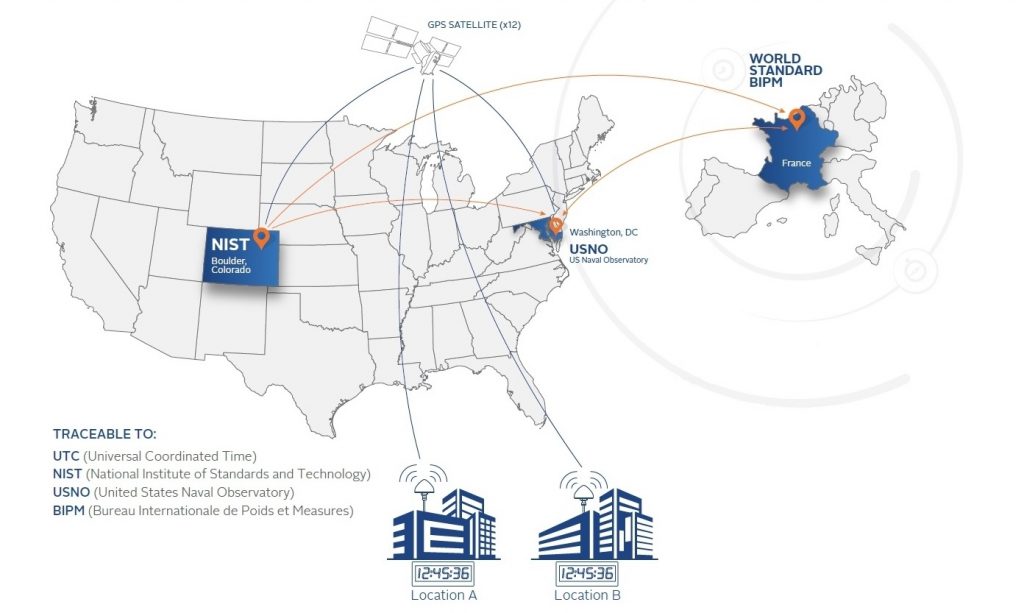
Legally Traceable Time
Precise time stamps, down to the nanosecond for some applications, is critical for many of Orolia’s clients. For fairness in stocks and futures trading these time stamps need to be traceable and verifiable, especially in volatile markets where fortunes can be gained and lost in a millisecond. This also applies also to banking transactions. Indeed, the financial sector is a key market segment for their services and solutions.
Orolia has even trademarked the term Legally Traceable Time®. Another key market for precise time is public safety; time stamping incidents to aid in investigations and legal proceedings. Reliable and traceable sources for time, be that from GNSS or terrestrial (e.g. fiber optics) is what Orolia’s NetClock, and other solutions provide, as this case study illustrates.
Positional Continuity
If you are running a positioning or navigation application, your biggest concern during a GNSS outage is how well your position can be maintained moving forward until GNSS is restored. If you have other positioning technologies running concurrently, they could take over, albeit likely not as precisely as the GNSS did.
For example, an IMU (inertial measurement unit) can take over, but with those the solution deteriorates, or drifts) over time. Add in data from an airspeed indicator, or wheel speed measurement device, and some of the drift can be addressed, but only for a defined period. Highly detailed 3D maps/models and image sets of cities can be checked with cameras or LiDAR for contextual position (though without access to the cloud that could be impractical).
There are alternate satnav systems, like those that are leveraging existing and expanding constellations of low earth orbit (LEO) satellites, though none have yet matched the real-time precision of GNSS. This is much the same as with ground-based radio ranging navigation solutions, beacons, Ultra-Wide Band, tech that leverages signals of opportunity, etc. More for coarse navigation than precise positioning, these represent much of the success in Alt PNT to date. High precision will likely come later.

“We have a platform approach for resilient PNT technology says Rohit Braggs, chief operating officer at Orolia. “We have solutions that have built-in oscillators and GNSS receivers that and can be integrated with data from multiple sensors or other signals of opportunity like LEO sats.” By doing this, we can provide precise time and frequency over GNSS outages and can provide positional continuity with integrated inertial sensors. “The form factors can vary from board level and compact size weight and power (SWaP) products that support applications that have smaller area, and where power management is key,” says Braggs. “Some customers need a ruggedized platform that acts as integrated PNT solution in harsher environments, for example, on payloads for on the move applications, or even a GIS mapping where they need to position and timestamp information constantly.”
Off the Radar
As a result of the fallout from the disappearance of Malaysia Airlines Flight MH370 and Air France Flight 447, international action has been taken in mandating location reporting technologies. When these tragedies were reported, it came as a surprise to many in the general public that an aircraft could be lost in this age of satellite positioning and communications.
The International Civil Aviation Organization (ICAO, a specialized agency of the United Nations) has set forth to implement the Global Aeronautical Distress and Safety System (GADSS) by January of 2023. How the system will work is that each aircraft will be able send 406 MHz distress beacons that the global COSPAS-SARSAT cooperative can relay to search and rescue authorities. These beacons will make it possible to locate an aircraft anywhere on earth, even in the absence of GNSS.
There have been various kinds of distress beacon systems on aircraft for many decades, but these have typically been standalone components that were not universally standardized and not integrated with a global detection and reporting system. In response to clients seeking to be in compliance with the new ICAO directive, Orolia has developed their Ultima-DT; a fixed Emergency Locator Transmitter.
“In this day and age, and with the amount of technology that’s available, it seems unbelievable that something as large a jetliner could not be tracked reliably, ,” says Braggs. “It took a few years to get all of the certifications and specifications through, but we are through the process, its finally done and we have our first solution. We now have the exclusive contract with Airbus,” says Braggs. “To provide and integrate GADSS compliant devices on their new aircrafts.”
Simulation
Implementing PNT on a large scale, like on the infrastructure of a region or telecommunication network, energy grid, or fleets of aircrafts, could be a risky proposition if the solutions were not proven to meet requisite performance metrics. This is why PNT developers must do extensive simulation and testing, or contract with firms that do. Orolia does their own, and also manufactures GNSS simulation solutions.
There was a time when GNSS testing involved simply running a cable up to an antenna on the roof to gather current observations, or using live sky to test PNT devices but PNT applications are much more sophisticated now. GNSS observations can be simulated in different locations around the globe, under different conditions, and “played back” to receivers in the lab. Further, signal generators can simulate nearly any scenario. Orolia produces advanced GNSS simulation hardware and software for a range of applications from high dynamic applications to basic GNSS testing.
Detection and Mitigation
Addressing jamming and spoofing of GNSS signals can be an effective strategy, and a good strategy to try before falling back to an Alt PNT (of likely lower precision). Orolia also develops detection and mitigation solutions. Though there may be multiple constellations, Braggs does not see that as providing much default resiliency: “After all, they are all very weak signals as received on the ground that can easily drowned out by jammers. If you can jam one GNSS signal. You can easily jam them all.” LEO satellite PNT does offer some advantages as the signals are much stronger and jammers have to be more powerful, making them much easier to detect and track.
Another layer of protection comes in the form of anti-jam antennas, hardware, and software. “Controlled Radiation Pattern (CRP) antennas can be a good first line of defense where, depending on the angle of arrival of the interference, you can directionally filter it out,” says Braggs. But CRP antennas can be large cumbersome, and quite expensive. For some defense applications they make sense, but for many commercial applications they might be impractical. There are other approaches. In addition to their simulation and testing to tools for jamming and spoofing, Orolia has their interference detection and mitigation IDM suite, that is software defined. This can be deployed to defense and commercial applications to provide resiliency where PNT information is critical.
Atomic Clocks
Orolia is also a world leader in high-end crystal, rubidium, maser and integrated GPS/GNSS clocks, as well as related testing instrument technologies for space missions that rely on high precision atomic clock technology.. And recently it was announced that they have been awarded two contracts to provide atomic clocks for the first 12 satellites of the Galileo Second Generation System (G2S).
Following the White Rabbit
In our August 2021 article “Don’t Forget the Time”, we profiled Seven Solutions, a firm focused on precision-time-related technology: highlighting their development of White Rabbit (WR) solutions. WR is a relatively recent wave of development to modernize data and control systems, with precise, secure, and resilient time transfer as a prime factor. On December 9, 2021, Orolia will complete an agreement to acquire Seven Solutions.
No “One-Size-Fits-All”
“The primary thesis of our resilient story is that there will not be one-size-fits all solution,” says Braggs. “The range of applications dependent on PNT is broad with different requirements on performance, accuracy, security and price”.
The nature of Alt PNT is to integrate multiple elements and solutions, layered or tiered based on precision, resilience, and reliability and deciding which one use and prioritize is challenging. “Each layer adds cost to the system. It is extremely complex for these decision makers to understand how many layers to use, and how much to spend. We have learned to offer significant degree of flexibility and options based on that and to simplify the complexity with our solutions tailored for the end-user” Future PNT will be a combination of whatever is out there, and whatever may come from this high-growth sub-industry of Alt PNT development. Orolia is one of the 18 (and growing) members of the Open PNT Industry Alliance. The OPIA has formed, to promote open markets to provide much needed protection and backups for GPS/GNSS-based positioning, navigation, and timing. And we will continue this series examining the key tech, developments, and developers of Alt PNT.

All images sourced from Orolia
*NOTE: “GPS” (Global Positioning System) has become a shorthand term for all satellite navigation (satnav). This made sense as the U.S. Navstar constellation (intimated in 1978) was the first and most commonly used. But I the decades since then, other satellite navigation constellations have been deployed: Glonass (Russia), Galileo (Europe), Beidou (China), QZSS (Japan), NavIC (India), and various regional augmentation systems. Together they serve as a “system of systems”—Global Navigation Satellite Systems—GNSS. These multiple constellations provide redundancy and performance gains that a single constellation could not. Multiple constellations continue to be broadly adopted for consumer to professional applications. “GPS” will likely still be used generically to refer to satnav, but for the purpose of articles like this, let’s start giving the term “GNSS” its proper due.


Be the first to comment