Avalanche Canada issues special warning for B.C. and Alberta
Avalanche Canada and Parks Canada had issued an advisory for many parts of British Columbia and Alberta during the week of February 10th. This interactive tool allows you to see what the avalanche risk is for alpine, treeline and below treeline for many parts of British Columbia and Alberta. Avalanche Canada is advising those who adventure into the backcountry to always check this interactive map to see warnings and alerts in the region.
Article can be viewed here.
First Nations use drone-seeding trial project to reforest wildfire ravaged areas west of Williams Lake
The Tsideldel First Nation and Tl’etinqox Government have collaborated with a company in Seattle called DroneSeed to focus on reforesting areas that have been devastated by wildfires. To reforest these areas, they use a drone that flies over and releases pucks that are filled with seeds and nutrients. Over a two-week period, the drone released 10,000 pucks per hectare covering an area of 52 hectares. Before the drones were in the air, lidar technology was used to detect the optimal spot to release the pucks, ideally in soil and not gravel. If this project is successful, they hope to expand to other areas that have been devastated by wildfires.
Article can be viewed here
Global glacier retreat measured for the first time in new study
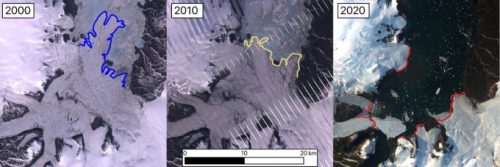
New research from the University of Ottawa suggests that almost all glaciers in the Northern Hemisphere have decreased in size during the past 20 years. William Kochtitzky and Luke Copland examined satellite imagery to measure glacier retreat and found that 85 percent of all glaciers they looked at had decreased in size. They also found that a massive 390 square kilometres of glacier ice melt had been occurring every year for the past 20 years.

Article can be viewed here
Drone company looks to self-piloted peregrines to patrol oilsands tailings ponds
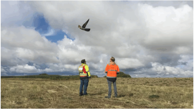
A drone is imitating the peregrine falcon to protect birds from the tailings ponds in the Alberta oilsands. A company by the name of Aerium Analytics, received a million dollars in funding and teamed up with the University of Alberta in hopes to make these drones fully autonomous over the next five to ten years. They used one of the most feared aerial predators, the peregrine falcon, to scare the birds away and to prevent them from landing on the tailings ponds.
Article can be viewed here
Here are the fastest growing and shrinking communities in Alberta
During the pandemic, many have decided to move out of urban centres and into the suburbs. A few interactive maps in Alberta are showing the population change since 2016. It can be noted that in both Edmonton and Calgary many neighborhoods in the centre of the city had decreased in population, while many areas in the suburbs had increased. The regions that observed the highest growth in population were, Cochrane, Airdrie, Beaumont, Mackenzie County, Canmore, Leduc, Blackfalds, Fort Saskatchewan, Chestermere and Spruce Grove.
Article can be viewed here
Wyvern gets funding to expand hyperspectral imaging market
The Canadian startup company Wyvern has received $7.65 million in funding from both the Canadian government and the private sector, for deployable optics technology. This funding will go towards developing a folding telescope. This technology will allow for a much cheaper hyperspectral imaging satellite that is smaller in size. Wyvern hopes to create a more affordable solution to obtaining high-resolution hyperspectral imaging.
Article can be viewed here


Be the first to comment