
- Canada’s Defence Department Spending Millions on American Cloud Services
- RFI Seeks Information on Commercial SAR Imagery Acquisition
- Map Helps Highlight the Need to Preserve Canada’s Peatlands
- Industry-Government Partnership Shares RADARSAR-2 Data to Protect Rain Forests
- Shrinking Arctic Ice has Security Implications for Canada
- Landsat Data for Canadians Looking to Reduce Environmental Risks
Canada’s Defence Department Spending Millions on American Cloud Services
Since 2021, the Government of Canada has spent $1.3 billion on American cloud service providers, with the Department of National Defence spending more than $10 million on cloud services for vital military operations. Presently, American cloud service providers are subject to US Law, being obligated to share data from foreign clients with US law enforcement if required. Prime Minister Carney has discussed the need for developing a sovereign cloud in Canada, where data and service providers fall under the jurisdiction of Canada, being independent of foreign governments.
Learn more here:
RFI Seeks Information on Commercial SAR Imagery Acquisition
Public Works and Government Services Canada (PSPC) has published a request for information (RFI) on behalf of the Canadian Space Agency (CSA), seeking input on CSA’s acquisition of commercial Synthetic Aperture Radar (SAR) data. Members of the industry can provide input in either French or English through the SAP Ariba portal by October 31st.
Learn more here:
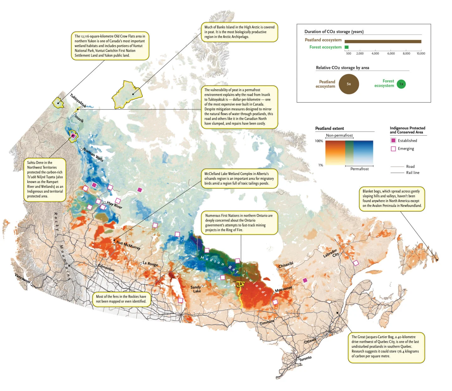
Map Helps Highlight the Need to Preserve Canada’s Peatlands
Canada contains 25% of the world’s peatlands, which are a vital ecosystem that helps mitigate floods and forest fires. Peatlands are increasingly under pressure from the impacts of climate change. A map created by the Wildlife Conservation Society Canada helps to highlight the extent of peatlands in Canada.
Learn more here:
Industry-Government Partnership Shares RADARSAR-2 Data to Protect Rain Forests
RADARSAT-2 Tropical Forests (R2TF) is a collaboration between MDA Space, the Canada Space Agency (CSA) and Natural Resource Canada’s Canada Centre for Mapping and Earth Observation (CCMEO). R2TF aims to provide RADARSAT-2 SAR data to universities and other recognized institutions in support of the assessment of humans and climate change-related impacts on global tropical rain forests. Data can be accessed through CCMEO’s Earth Observation and Data Management System (EODMS), with data being available from 2012 onward.
Learn more here:
Shrinking Arctic Ice has Security Implications for Canada
In 2025, Arctic Sea ice cover reached one of its lowest recorded measurements. The Government of Canada, having previously recognized the threats posed by receding Arctic ice – concerns related to increased traffic and geopolitical changes – has pledged to purchase 12 Arctic-capable submarines and 8 icebreakers in response. One defence company currently active in Canada is the Norway-based Kongsberg. Kongsberg provides weapons, vehicles, components, training, and geospatial services to the Canadian Armed Forces.
Read more here:
Landsat Data for Canadians Looking to Reduce Environmental Risks
The Landsat Program has provided more than 50 years of satellite data, which has proved a useful tool for monitoring changes in land, surface water, and vegetation cover. Data from Landsat has been used to reduce the environmental impacts of large developments, such as the Thacker Pass lithium project in Nevada.
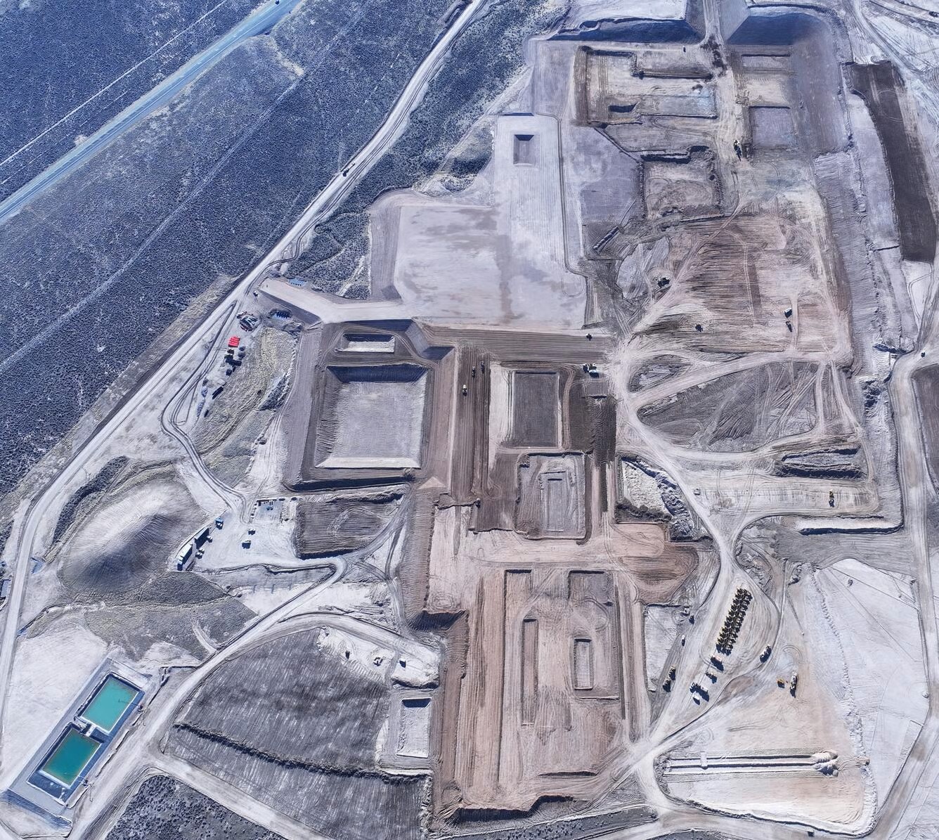
In Canada, we have access to RADARSAT and the Canada Centre for Remote Sensing, whose data can help reduce the environmental impacts of large projects. This is an increasingly important consideration, especially as natural resource and infrastructure development is expected to increase in Northern Canada.
Read more here:


Be the first to comment