- GPS (Global Positioning System) – United States
- Operational Date: 1978 (Initial operational capability), 1995 (Full operational capability)
- GLONASS (Global Navigation Satellite System) – Russia
- Operational Date: 1982 (Initial operational capability), 1996 (Full operational capability), 2011 (Restored full global coverage after modernization)
- BeiDou (BDS) – China
- Operational Date: 2000 (Initial regional coverage, BeiDou-1), 2012 (BeiDou-2 with wider Asia-Pacific coverage), 2020 (BeiDou-3 with full global coverage)
- Galileo – European Union
- Operational Date: 2016 (Initial operational services), 2019 (Full operational capability)
- QZSS (Quasi-Zenith Satellite System) – Japan
- Operational Date: 2018 (Initial operational capability)
- NavIC (Navigation with Indian Constellation) – India
- Operational Date: 2018 (Regional operational capability)
Global Navigational Satellite Systems(GNSS)
Traveling to another country and figuring out a restaurant there. How simple is it now? Monitoring your hike and keeping follow up on your steps. It sounds easy now. Sending your location to a buddy or say predicting the time it will take to arrive at your destination might seem to be simple and straightforward.
Our daily lives have become increasingly influenced by our location. And, despite the fact that they use navigation systems on a daily basis, most people are unaware of how they work.
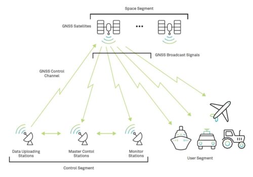
Global Navigational Satellite Systems (GNSS) encompasses a system that’s composed of multiple constellations of satellites in Earth’s orbit. These satellites continuously transmit signals to the master control stations about their location in the sky. Users of GNSS across the planet receive this signal through receiver.
The history of GNSS goes back to 1957, when the then-known Soviet Union was the first to float ‘Sputnik’ into the earth’s orbit. The basis of this first satellite was to use radio waves for communication and military purposes.
Satellite systems have been continuously evolving after that. Different countries have tried their hands at adding their own satellite to GNSS. The system that started mainly for military usage has turned into one of the finest and most refined realms for global navigation, positioning, and timing.
GPS – Global Positioning System
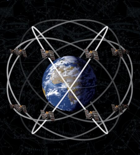
GPS, a global positioning system run by the United States Space Force, a part of the US Armed Forces, was the first known constellation to be built in space. It launched its first satellite in 1978 and completed its first series of satellites, all of which were completely operational by 1993.
GPS has finally made its way into civilian hands thanks to its fast increasing network and functional capabilities. GPS was the first to be accessible via cellphones in 1999. In 2000, the United States government approved three new GPS signals for non-military applications.
Furthermore, GPS signals continuously become stronger and more accurate, with the government ending the ‘selective availability’ program that deliberately generated errors in GPS signals for national security reasons. For many, GPS was and continues to be the sole available navigation system. Since then, GPS has been progressively expanding its network of satellites with more advanced configuration and capabilities.
Currently, the system comprises 31 satellites in orbit that support L1 (1575.42 MHz), L2 (1227.60 MHz), and L5 (1176.45 MHz) frequencies.
GLONASS (Global Navigation Satellite System), Russia
GLONASS was initially launched into space in the 1970s by the Soviet Union. This launch was primarily intended to serve military goals. Understanding the business implications of its capacity to transmit weather, communication, and navigation, the first commercial GLONASS was launched in 1982 and was fully operational by 1993.
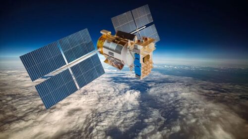
The GLONASS space segment is made up of a constellation that revolves about every eight days. The satellites are positioned in approximately circular orbits with target orientations of 64.8 degrees and an orbital radius of 19,140 kilometres (11,893 miles), which is around 1,060 kilometres (659 miles) lower than GPS satellites.
With the same polarization and signal strength as GPS signals, GLONASS satellites share the frequencies by having antipodal satellites transmit on the same frequency, which are 180 degrees apart from each other.
GLONASS currently has a fully deployed network of 24 satellites.
Galileo
Galileo is a global navigation satellite system (GNSS) developed by the European Union through the European Space Agency (ESA) and managed by the European Union Agency for the Space Programme (EUSPA).
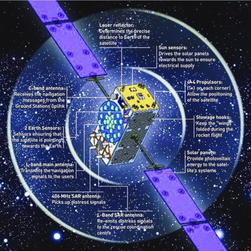
Galileo is designed to provide an independent high-precision positioning system for European political and military authorities, eliminating the need to rely on US GPS or Russian GLONASS systems, which may be disabled or downgraded by their operators at any time.
The Galileo Space Segment consists of a constellation of 30 Medium Earth Orbit (MEO) satellites, three of which are spare. Each satellite will transmit precise time signals, ephemeris, and other information.
Basic (lower-precision) Galileo services are free and accessible to everyone. Government-authorized clientele can access a fully encrypted, higher-precision service for free. Galileo will include a new global search and rescue (SAR) function in the MEOSAR system.
By this year’s September, the constellation has 25 satellites afloat. By 2026, the next generation of satellites is anticipated to become functional and replace the first generation, which can thereafter find its spot in the backup.
BeiDou
BeiDou (BDS) is a navigation satellite system based on radio navigation. It is owned and operated by China’s National Space Administration. It sends geolocation and time information to a BDS receiver anywhere on or near Earth with an unimpeded line of sight to four or more BDS satellites. It does not require the user to transmit any data and operates independently of telephonic or Internet reception; however, these technologies can improve the use of BDS positional data.

Being a national space infrastructure, BDS provides high-accuracy location, navigation, and timing services at all times and in any weather at the national as well as international level. Following one of its development philosophies, “gradualness,” Beidou had commenced on a “three-step strategy development” process. Starting with BDS in 1994, the second-step BDS was completed by the end of 2012, with a total of 14 satellites. The third step, BDS, eventually completed a network of 35 satellites by 2020, ensuring dependable and safe BDS operations.
Beidou features a combination of constellation with three types of orbits.
- In comparison to other satellite systems, BDS runs more satellites in higher orbits, provi–ding superior antishielding capabilities.
- Enabling navigation via multiple frequencies, it is able to enhance service accuracy.
- Weaving together navigation and communication capabilities, BDS offers five outstanding functions: real-time navigation, quick positioning, exact timing, location reporting, and short message communication services.
Beidou has made significant contributions to the worldwide navigation satellite system, built with the objective of meeting the needs of the country’s national security, economic and social growth, and delivering continuous, stable, and dependable services for global users.
QZSS – Quasi-Zenith Satellite System
The regional navigation satellite system also includes the Quasi-Zenith Satellite System (QZSS). QZSS, authorized by the Japanese government in 2002 as the National Space Development Program, encompasses East Asia and Oceania. Its system is not intended to operate independently, but rather in conjunction with data from other GNSS satellites.
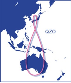
Satellite positioning information is better with four or more satellites.. Pairing GPS and QZSS safeguards that there are enough satellites for stable, high-precision locating while also covering areas with buildings, trees, and mountains where signals are more likely to be obstructed.
In addition, QZSS is GPS receiver compliant and less expensive. QZSS (Michibiki) has been operating as a four-satellite constellation since November 2018, with three satellites visible at all times from Asia-Oceania. Interoperability is a fundamental criterion for QZSS systems, running in the same frequency bands as multi-GNSS systems without disruptive interruption. QZSS applications include mobile mapping, IT-assisted precision farming, IT-assisted construction, fleet management, marine and transportation applications, among others.
The three new satellites to complete the 7-satellite constellation were scheduled to launch between 2022 and 2023 and have now all three been delayed further into 2023
NavIC – Navigation with Indian Constellations
Navigation Indian Constellation (NAVIC), formerly known as the Indian Regional Navigational Satellite System (IRNSS), was created by the Indian Space Research Organization (ISRO).
NAVIC is an independent, autonomous regional satellite system owned by the Indian government with a service area of 1500 kilometers surrounding India. The space section, ground segment, and user receivers would all be developed in India, ensuring complete Indian control over the system.
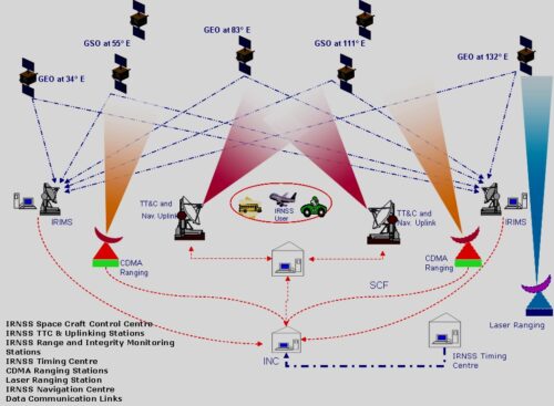
IRNSS has at least 7 satellites and necessary ground infrastructure. As is customary in GNSS systems, the architecture is divided into three sections: the space segment, the ground segment, and the user segment. There will be two types of services:
- Special Positioning Service(SPS)
- Precision Service(PS), respectively
The predicted performance of the IRNSS system is: position accuracy about 20 m across the Indian Ocean Region (1500 km around India), and less than 10 m accuracy over India and GSO nearby countries.
References:
https://aerospace.org/article/brief-history-gps
https://novatel.com/an-introduction-to-gnss/gnss-constellations/glonass
https://www.esa.int/Applications/Satellite_navigation/Galileo/Galileo_satellites
https://en.wikipedia.org/wiki/BeiDou
http://en.beidou.gov.cn/SYSTEMS/WhitePaper/201806/P020180608507822432019.pdf
https://gssc.esa.int/navipedia/index.php/NAVIC




Be the first to comment