Mapping threats to land mammals, amphibians and birds
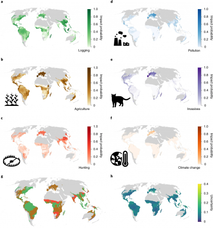
Climate change and human activities are both causing challenges for different animals to survive around the world. A recent study used the data published from the IUCN Red List of endangered species to map current threats that mammals, birds and amphibians are facing currently at global scale. Six major factors are mentioned according to the study, including agriculture, climate change, hunting, invasive species, logging and pollution. The biodiversity threats are more likely to occur in the Himalayas, Southeast Asia, Madagascar, Central Africa, and the Amazon Basin. The author believes this study can inspire future local studies to develop appropriate local solutions.

Learn more here: https://news.mongabay.com/2021/09/mapping-threats-to-land-mammals-amphibians-and-birds-study/
Mixed reality 3D geospatial visualization
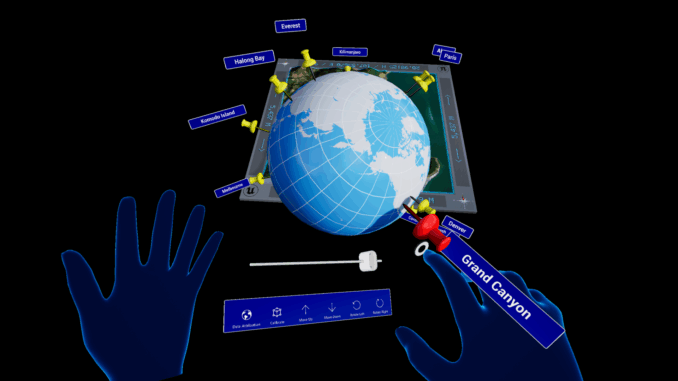
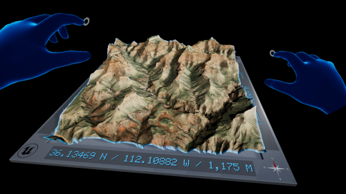
The development of extended reality (XR) technology has boomed during the pandemic as the demand has risen. 3D geospatial company Cesium joined the alliance with NVIDIA and Microsoft to develop a real-time interactive simulation environment. In this project, the 3D tile products created by Cesium can be streamed to Microsoft’s HoloLens2, a laser-based stereoscopic mixed-reality smartglasses. The reconstruction of 3D scenes is enhanced with the help of Unreal Engine. Users can select the region of interest to navigate themselves freely through detailed terrains and buildings. Basemaps and building data are contributed by Bing map and OpenStreetMap. This XR technology is demonstrated at the GEOINT Symposium last week.

Learn more here: https://www.geospatialworld.net/news/introducing-project-anywhere-xr-a-free-sample-project-for-mixed-reality-3d-geospatial-visualization/
Mapping shows how weather events affect the Australian Reef
The University of Queensland and the Australian Institute of Marine Science and the Great Barrier Reef Marine Park Authority are developing a new technology, which combines satellite imagery and underwater field mapping result to create the biological terrain about the Great Barrier Reef at the Australian coast. The result is promising, showing details about how the reefs are connected. The mapping tool is used to monitor the condition of individual reefs more accurately. Alike the news about the IUCN Red List of endangered species that mentioned above, the coral reef is also facing extinction threats due to climate change. Authorities expect that field knowledge and high resolution satellite images can be used to improve mapping methodologies.

Learn more here: https://www.themandarin.com.au/169999-mapping-shows-how-great-barrier-reef-is-impacted-by-major-weather-events/
UN map tool shows flood map worldwide since 1985
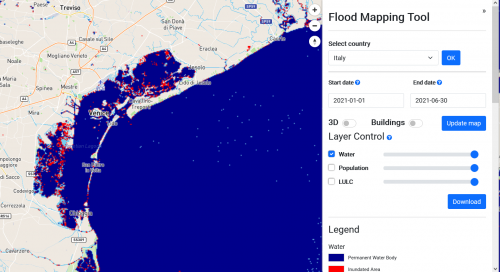
The United Nations released a free mapping platform, The World Flood Mapping Tool, to produce instance maps showing floods after 1985 worldwide. It uses Landsat data and Google Earth Engine to provide a 30-meter resolution at street level, allowing users to add variables and study flooding phenomenon. According to a recent survey conducted by the UN, some flood-prone countries do not have the ability to run complex forecasting models. Authorities has predicted that more populations will expose to intense flooding events in the future because of climate change. With the help of this mapping tool, governments can decide when and where to upgrade infrastructures or replant vegetation.

Learn more here: https://www.independent.co.uk./climate-change/news/flood-un-map-climate-crisis-b1930681.html
Apple introduces new AI platform to handle complex spatial datasets
Apple is on its way to develop a new platform that requires minimal coding knowledge, encouraging more people to develop applications from complex spatial datasets. The Trinity AI is the latest no-code platform that allows non-developers to produce deep learning geospatial models, particularly on the mobile phone operation system. The decision is inspired after the succeed of SwiftUI which requires much less coding knowledge when compared with traditional programming language. People without knowledge about machine learning but know how to build apps will be able to create their own application with Trinity AI. Trinity will mainly focusing on application development with geospatial data.

Learn more here: https://venturebeat.com/2021/10/01/apples-no-code-trinity-ai-platform-handles-complex-spatial-datasets/


Be the first to comment