
- Mapping Mineral Resources at Opposite Poles
- New Project Unveils More Detailed Map of Antarctic Bedrock
- China Expanding Seabed Mapping Efforts for Science, Defence
- Niantic Sells off Gaming Divison; Shifts to Geospatial and AR
- A Changing Climate May Mean More Satellite Collisions
- Satelytics Receives Recognition for AI-driven Software that Improves Methane Leak Detection
Mapping Mineral Resources at Opposite Poles
Australia and Greenland have long been known for their abundance of valuable natural resources. However, with changing global geopolitics and increasing headlines surrounding the two, some maps that highlight their bounties seem timely. A new map of Australia highlights its reserves of critical rare earth minerals, essential for modern technology and defence industries, which are likely to be used as a bargaining chip with the U.S. in a growing tariff dispute. Elsewhere, some informative maps and graphics help us to familiarize ourselves with Greenland and its resources, while providing some context to the renewed U.S. interest in Denmark’s northern territory. As Donald Trump’s tariffs and trade policies push the U.S. to seek alternative sources for rare earth elements, reducing reliance on China has fueled American interest in both Australia’s established mining sector and Greenland’s developing potential. Additionally, Greenland’s strategic role is underscored by the U.S. military’s presence at Thule Air Base.
Read about Australia here, and Greenland here.
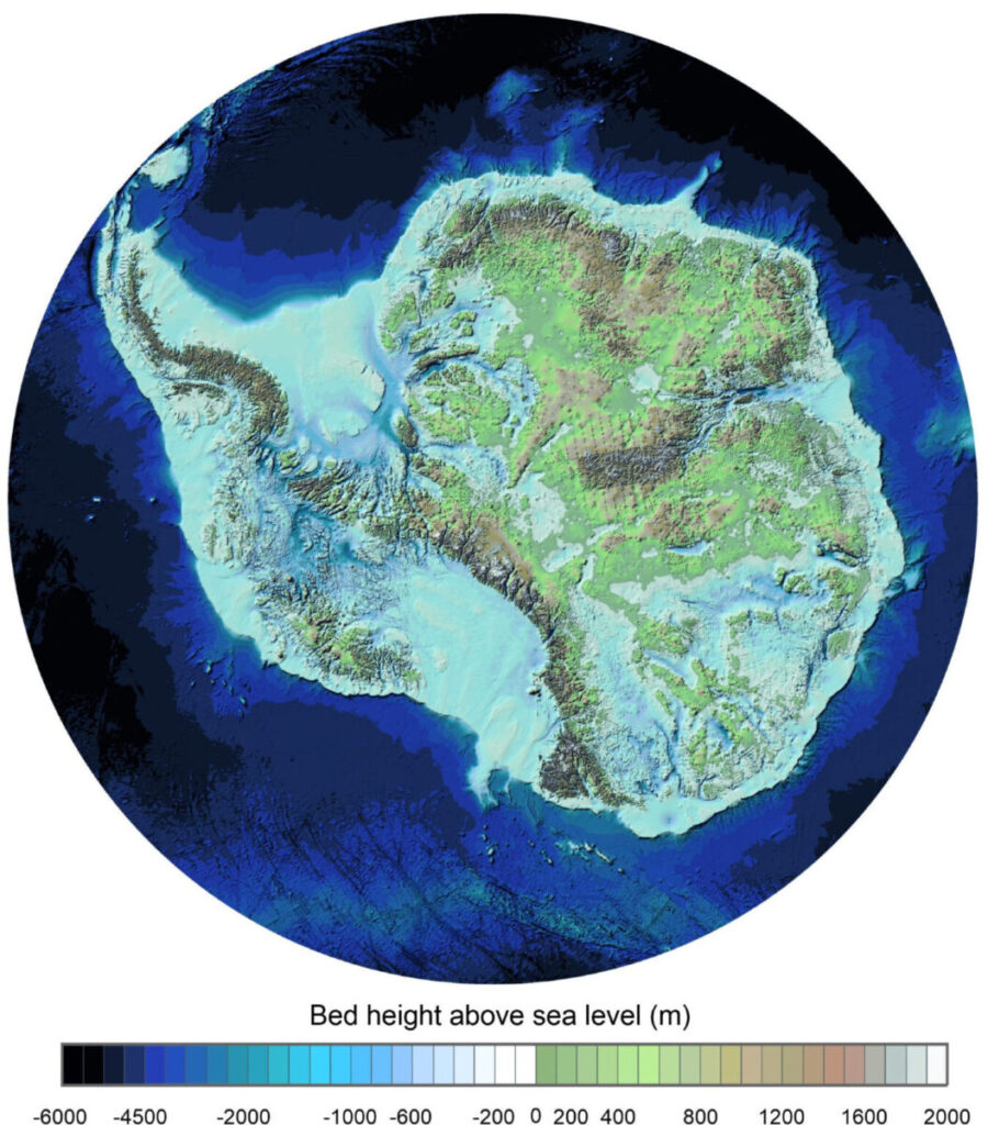
New Project Unveils More Detailed Map of Antarctic Bedrock
A team of international scientists led by the British Antarctic Survey have released the most detailed map yet of Antarctica’s hidden topography. New mountains, valleys, and deep canyons are revealed, offering new insights into the geological history of the continent. The map was created using decades of survey data from aircraft, satellites, ships, and even dog sleds, and contains more than double the number of data points of the previous map at a whopping 82 million. This new data should help improve predictions of how Antarctica’s ice will respond to climate change, refining future sea-level rise projections.
Read more here.
China Expanding Seabed Mapping Efforts for Science, Defence
China has increased its mapping efforts of the seabed recently, expanding beyond its territorial waters with a fleet whose research and mapping are aimed at strategic advantages in future warfare. Detailed underwater mapping can help in submarine operations, underwater drone deployments, and securing deep-sea resources. Much like US efforts in the past, the new effort aligns with China’s broader military and economic ambitions, while also being thought to include mineral exploration efforts in areas like the Cook Islands. Experts warn that this knowledge could give China a tactical edge in conflicts by enhancing stealth capabilities and disrupting rival naval operations.
Read more here.
Niantic Sells off Gaming Divison, Shifts to Geospatial and AR
Niantic, the company behind Pokémon GO, is selling off its gaming division to focus on geospatial AI and AR technology. The move highlights Niantic’s growing efforts in augmented reality and mapping tools rather than game development. The company’s stated goals include creating “spatial intelligence that helps people better understand, navigate, and engage with the physical world”, and given the strong portfolio of location-based games, such as Pokémon GO, Ingress, and Peridot, they should be an interesting company to watch in the near future.
Read more here.
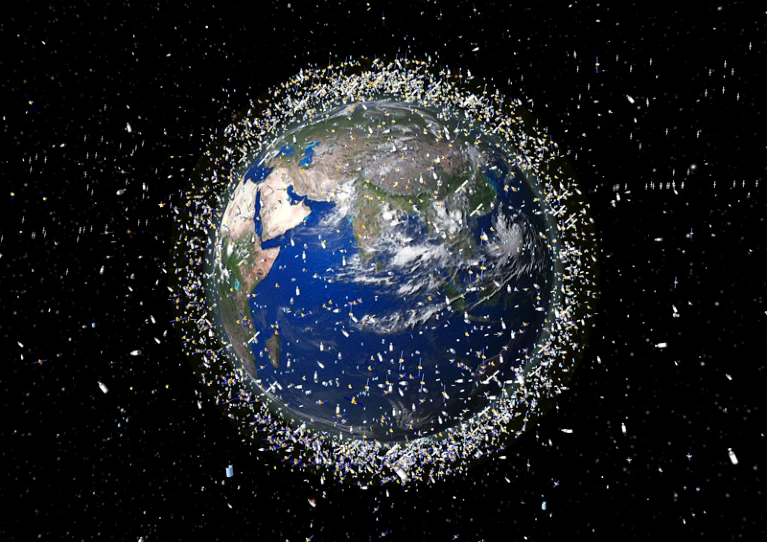
A Changing Climate May Mean More Satellite Collisions
A new addition to the list of unintended and unforeseen consequences of climate change is an increase in satellite collisions, according to a new study. Rising CO₂ levels may cool and contract the thermosphere, thereby reducing atmospheric drag and causing space debris to linger in orbit for longer. The study suggests that congestion in Earth’s orbit could grow by 30% by 2100, thereby raising the risk of crashes. This continues to highlight the need for better space traffic management and de-orbiting strategies to prevent overcrowding. With satellites being crucial for communication, navigation, and climate monitoring, scientists stress the urgency of sustainable satellite deployment to ensure safe and continued access to Earth’s orbit.
Read more here.
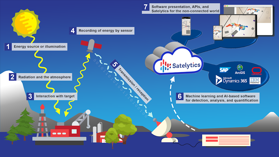
Satelytics Receives Recognition for AI-driven Software that Improves Methane Leak Detection
Geospatial analytics company Satelytics has been named to Fast Company’s 2025 most innovative companies list, in the data science category. Satelytics’ AI-driven software analyzes satellite and aerial imagery to detect methane leaks as small as 1kg/hour from space. Working with one client in North Carolina, the platform identified 433 methane plumes during its initial scan, and its accuracy grew from 70% to 95% as its machine learning algorithms were improved. Fast Company’s recognition highlights the growing importance of AI-powered remote sensing in environmental protection and industrial management.
Read more here.


Be the first to comment