The earliest French settlers in North America were drawn in the 16th century to the area now known as Québec City, which sits on the north bank of the Saint Lawrence River and is home to a web of smaller rivers and lakes including the Saint-Charles River. Over the last 500 years, these watercourses supported both trade and transport, helping Québec City to grow into a prosperous city with more than 500,000 residents. But with climate change leading to rising water levels and potential flooding, the residents of Québec City must now prepare for the potential threat caused by their beloved rivers and lakes.
In 2017 and 2019, a combination of heavy rain and snowfall caused significant flooding in Montreal and other areas of Québec. While Québec City itself was not affected, the significant disruption and economic damage caused by the flooding led Québec’s Ministry of Public Safety to launch an action plan for flood preparedness and civil security. The Communauté métropolitaine de Québec (CMQuébec) recognized the need to map, analyze and model its watercourses in order to understand the potential consequences of flooding and rising water levels.
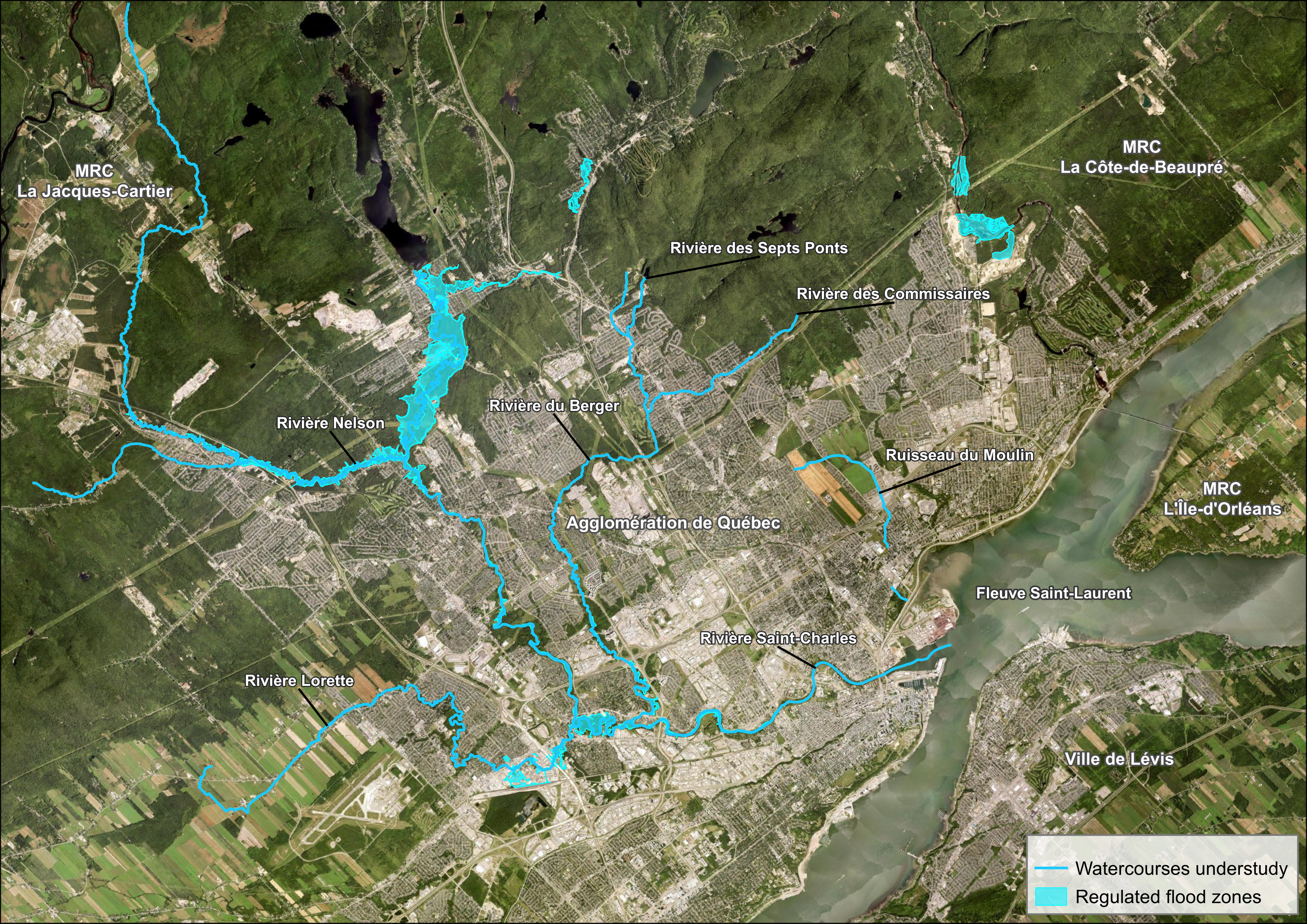 CMQuébec 2022 study areas and current regulated flood zones. Image by Frédérick Lafrance, CMQuébec.
CMQuébec conducted its first topobathymetric Lidar surveys in 2019. The results of this project demonstrated the importance of gathering and maintaining accurate models of the watercourses and surrounding terrain. Building off those first surveys, CMQuébec commissioned surveys of eight new watercourses in late 2022. The city expected the expanded data sets to provide crucial information for accurate hydraulic modeling, allowing local government institutions and businesses to prepare for any flooding event.
Following CMQuébec’s first topobathymetric Lidar surveys, they understood the difficulty of their new assignment. The weather in the metropolitan region can be highly unpredictable during the fall, and heavy winds and rain can stand in the way of useful surveys. CMQuébec chose NV5 Geospatial (NV5) to conduct the surveys during the late summer of 2022; the NV5 team spent nearly a month in Québec City to ensure success.
Productive Collaboration and Communication
CMQuébec contracted NV5 to collect the topobathymetric Lidar data during leaf-on conditions for an area of interest containing eight rivers surrounding Québec City. The community and NV5 worked together collaboratively in order to prepare an effective flight plan. CMQuébec drew on the experience from its previous topobathymetric Lidar survey, as well as its intimate local knowledge of the watercourses and weather patterns, to provide valuable recommendations to NV5’s survey team. CMQuébec also took responsibility for pre-flight ground surveys, doing everything possible to set the project on the right course.
“We wanted to make sure we were planning effectively for this survey,” said Frédérick Lafrance, geospatial developer at Communauté métropolitaine de Québec. “What are the challenging areas that we can anticipate? Do we have structures on the river that control flows? Can we target the lowest flows possible to decrease levels in the challenging areas? We wanted to simplify the survey for NV5 and maximize the results, and we worked hard to get that information and share it at our kickoff meeting.”
 St Charles River, Pointe-aux-Lièvres Park. Lidar-derived surface model – bathymetry shaded by depth. Image by Chris Miwa, NV5 Geospatial.
The teams continuously monitored weather conditions and potential hazards, as inclement weather would have an immediate impact on both airborne and ground operations. NV5 also prepared for logistical considerations such as water clarity, air space restrictions, tide conditions, and private property access.
NV5 conducted the topobathymetric Lidar survey using a Leica Chiroptera 4X shallow channel topobathymetric Lidar sensor and a Leica HawkEye 4X deep channel bathymetric Lidar sensor mounted in a Piper Navajo. The team surveyed more than 7,000 acres over the course of five days, including nearly 2,000 acres along the Saint-Charles River.
Given CMQuébec’s previous experience with topobathymetric Lidar, the community hoped to carefully review the data as soon as possible following each survey to follow the progress of the new project. NV5 used its client portal, INSITE, to deliver the collected data in near-real time. This tool proved to be particularly valuable to both CMQuébec and NV5, as it helped them to immediately understand the success of a particular flight — and determine whether it would be necessary to refly the same area.
 Rivière du Berger. Lidar-derived surface model with bathymetry shaded by depth and cross-section of classified lidar point cloud. Image by Chris Miwa, NV5 Geospatial.
An innovative approach to data processing
In the aftermath of a topobathymetric Lidar survey, the data processing staff will typically evaluate which of the flights delivered the best results and perform a series of manual and automated tasks to process that data. However, the unpredictable and quickly-changing Québec City weather left the NV5 team with an interesting challenge. No single day stood out for delivering the best data across the entire survey area; instead, each flight provided exceptional results for one part of the survey, while quickly-moving rainstorms had a negative impact on other areas of the survey.
Rather than choose to compromise on the quality of the end result, the NV5 team stitched together the best areas of each flight in a single point cloud. NV5 conducted several processing tasks, including GPS control computations, smoothed best estimate trajectory calculations, and Lidar point classification. The resulting point cloud ensured that CMQuébec received the most accurate possible result from the combined survey efforts, which will help to inform years of hydraulic modeling and flood planning.
“NV5 stayed for a long time in Québec City, which meant we didn’t have to rush into doing the survey,” said Lafrance. “This helped to maximize the data. And of course, it was nice to be able to see the results in real time. This was essential, because we could then be part of the decision on when and where to refly if necessary. NV5 allowed us to be more involved in the process, and that was really important for the end result.”
The completed topobathymetric Lidar survey represents an important first step, as the result will be the first complete bathymetric digital model in Québec City. CMQuébec expects the model to provide the foundation for further research and planning, particularly for hydraulic modeling. Over the long term, this information will lead to a safer and more prosperous Québec City — one that’s prepared for the next 500 years along its web of watercourses.
 St Charles River. Lidar-derived surface model – bathymetry shaded by depth. Image by Chris Miwa, NV5 Geospatial.
About the author:
Sven Cowan lives in Vancouver, BC and serves as NV5 Geospatial’s Canada Program Manager. Sven has over 20 years of experience in customer-facing positions within the geospatial information industry and has worked for multiple geospatial remote sensing organizations in various Account Management, Technical Services, and Customer Experience roles. His current focus includes regional strategy, business development, relationship management, and brand awareness.
About NV5 Geospatial:
NV5 Geospatial is a provider of geospatial services, providing end-to-end solutions and insights to organizations that need geospatial intelligence to mitigate risk, plan for growth, better manage resources and advance scientific understanding. We combine the widest array of advanced remote sensing technologies with proprietary processes, analytics tools, algorithms, and analyses tailored to meet our clients’ needs. For more information visit nv5geospatial.com, join us on LinkedIn, or follow us on Twitter @nv5geospatial.

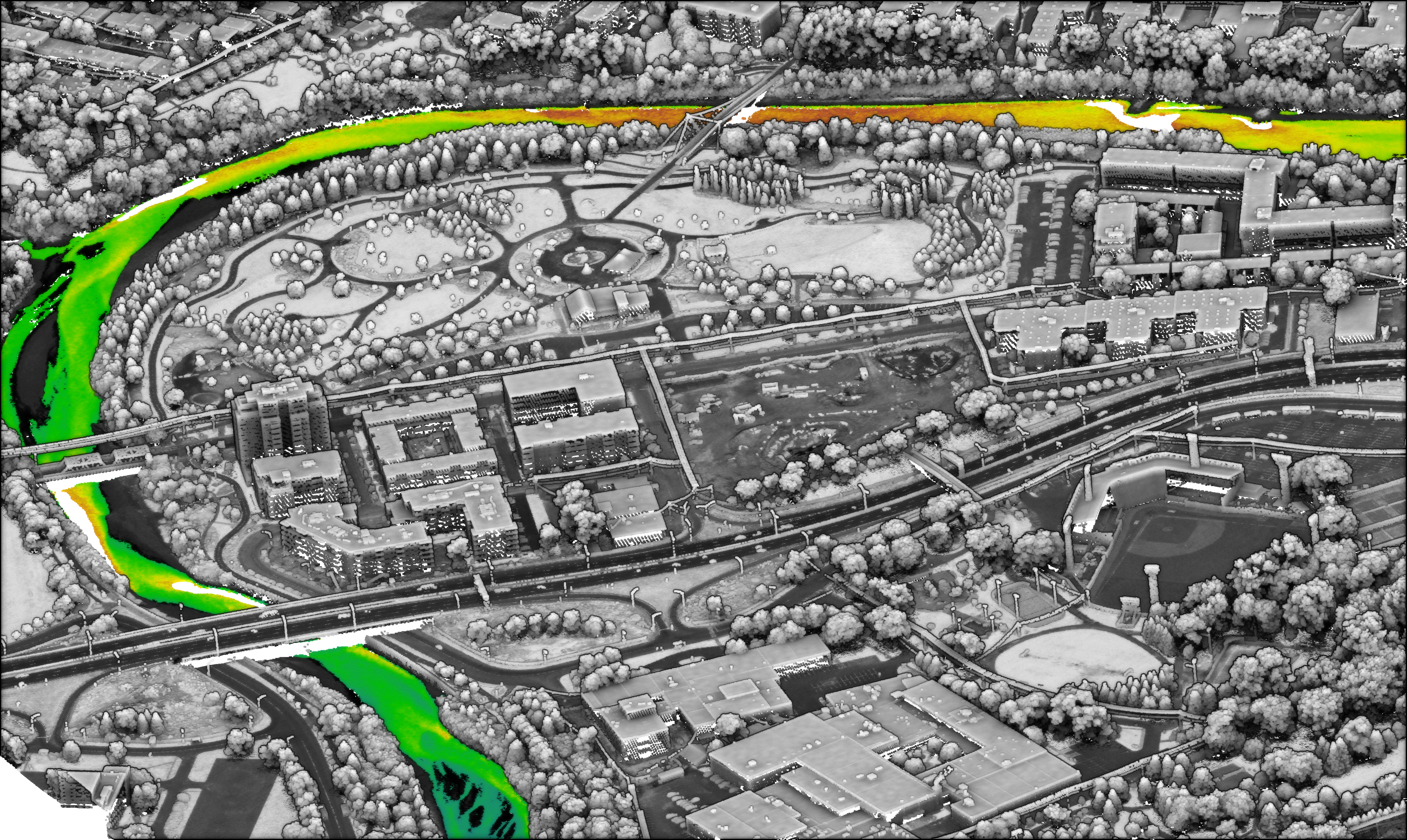 St Charles River, Pointe-aux-Lièvres Park. Lidar-derived surface model – bathymetry shaded by depth. Image by Chris Miwa, NV5 Geospatial.
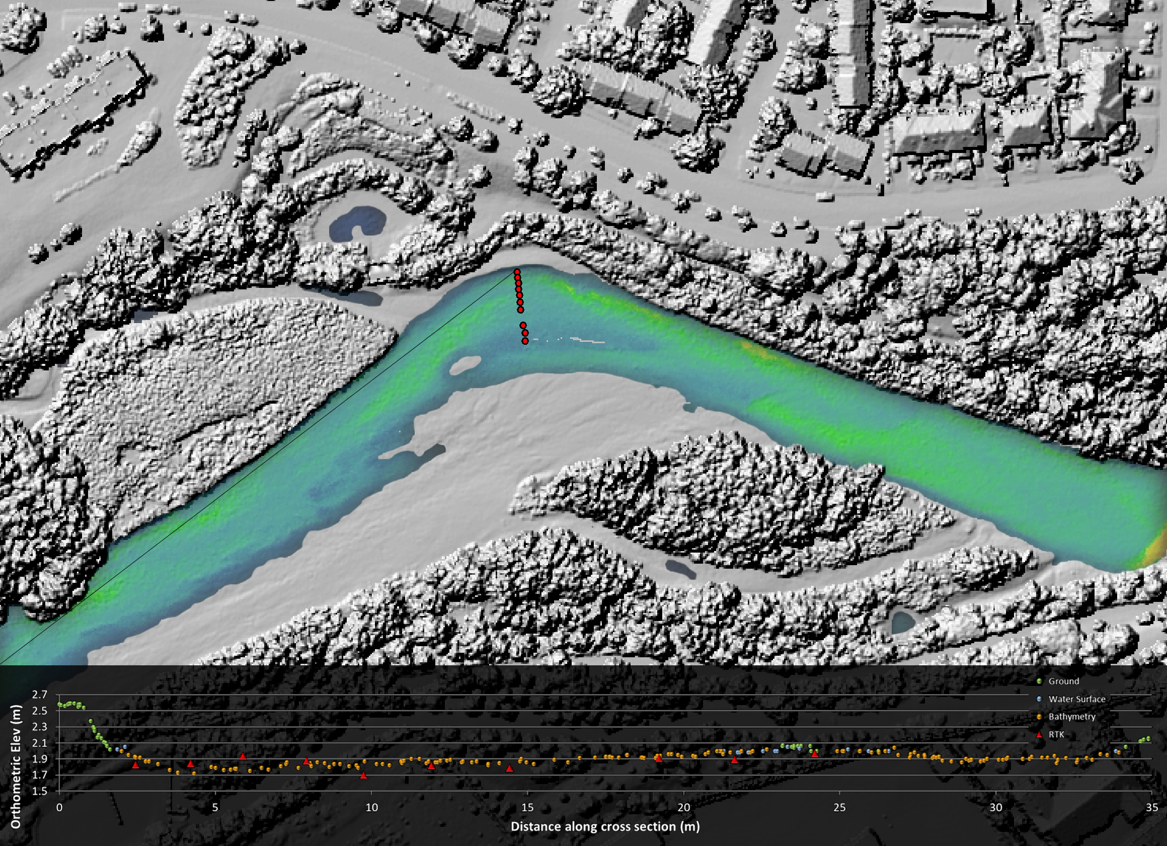 Rivière du Berger. Lidar-derived surface model with bathymetry shaded by depth and cross-section of classified lidar point cloud. Image by Chris Miwa, NV5 Geospatial.
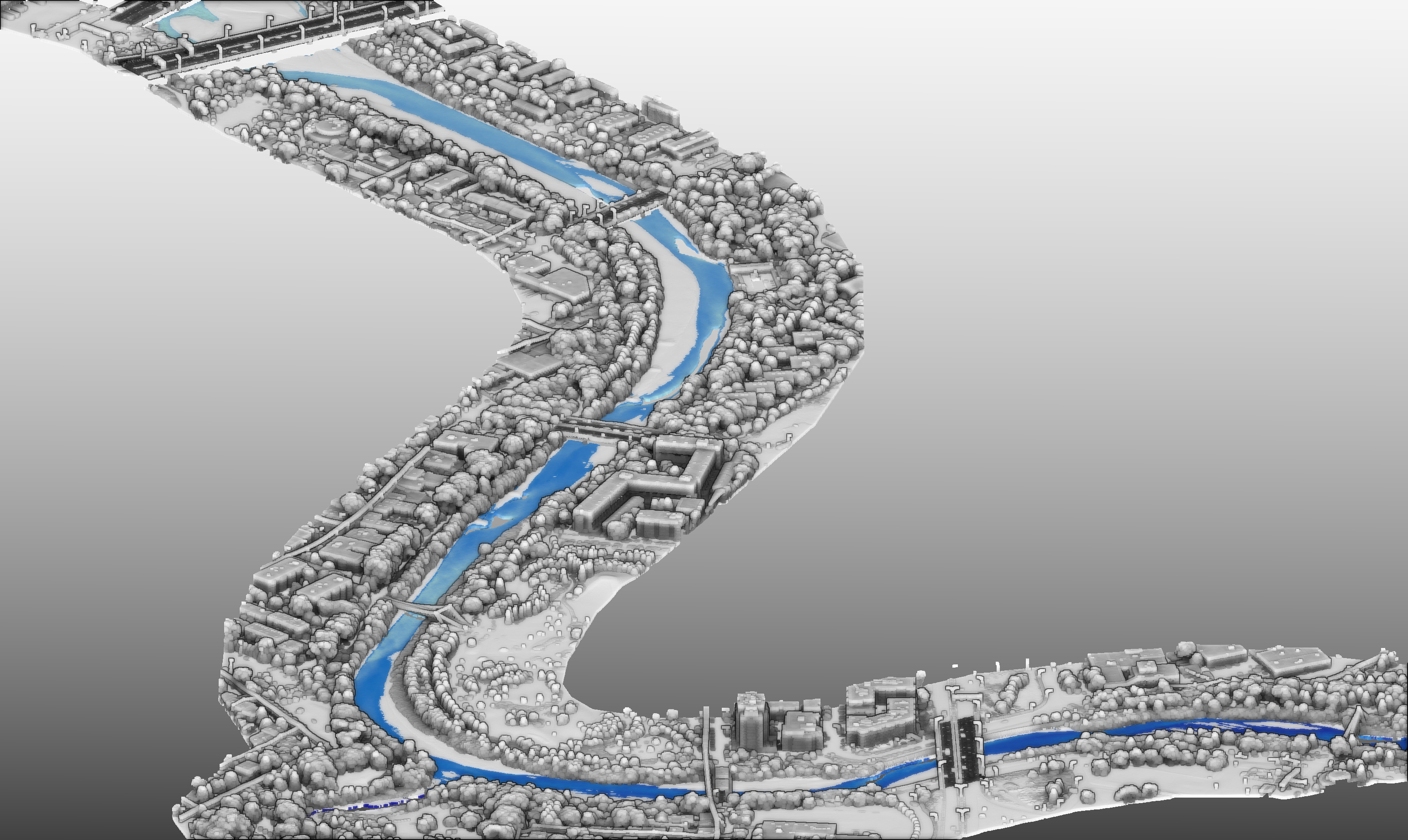 St Charles River. Lidar-derived surface model – bathymetry shaded by depth. Image by Chris Miwa, NV5 Geospatial.

Be the first to comment