Water is crucial for all life on Earth, and as the planet increasingly feels the effects of climate change, freshwater is becoming an even more contentious issue. Canadians are fortunate to possess approximately 20% of the world’s freshwater resources. However, much of this water is concentrated in large lakes and rivers, many of which are non-renewable, and may eventually diminish due to environmental changes and overuse.
At the same time, the politics surrounding water are shifting across North America. As the U.S. grapples with chronic water shortages in several regions, tensions with Canada are rising. Recent political shifts, including U.S. President Donald Trump’s aggressive stance on trade and environmental policies, have sparked concerns that the U.S. may push for greater control over shared water resources. This raises not only questions about environmental management but also about the long-term sustainability of Canada’s water supplies.
The U.S. has indicated that it may seek to divert water from the Columbia River Basin to alleviate its own water shortages, which could significantly affect the water flow into Canada. This potential for unilateral action has prompted British Columbia to prepare for the possibility of the U.S. making independent decisions, especially as climate change exacerbates water scarcity across the western U.S. The future of the Columbia River Treaty, which has governed water use between the two nations since 1964, is now in question. It remains unclear how this dispute over water management will unfold.

Meanwhile, the Great Lakes — one of the largest freshwater systems in the world — has also become a focal point in U.S.-Canada water disputes. In 2024, the two countries jointly launched an initiative to transform the Great Lakes region into a blue-green economic development corridor, aiming to leverage the lakes’ water resources for economic growth. However, this ambitious project is facing significant challenges, largely due to the political climate shaped by the U.S. administration. Reports suggest that U.S. is now threatening to dismantle agreements governing the Great Lakes, which could pave the way for the diversion of water from the lakes to other parts of the U.S. Further, the proposed elimination of funding for the Great Lakes Restoration Initiative poses a threat to future environmental protection efforts.
While the political dynamics between the U.S. and Canada remain uncertain, Canada is actively working to protect and manage its freshwater resources. With its vast and valuable water reserves, Canada is not only focusing on maintaining the quality and quantity of its freshwater but also on ensuring sustainable management practices to protect these resources for future generations. From federal initiatives to provincial projects, various levels of government are working in tandem to address both environmental and infrastructural challenges.
Let’s take a closer look at the steps Canada is taking to ensure the sustainability and protection of its vital freshwater systems.
The Canada Water Agency
The Canada Water Agency (CWA) is a new agency within the Government of Canada tasked with keeping water safe, clean and well-managed. Initially proposed in 2019, the CWA began as a branch of Environment and Climate Change Canada, before transforming into a standalone agency in 2024.
The CWA is responsible for a wide range of tasks including overseeing freshwater ecosystem initiatives and research, creating a National Freshwater Data Strategy, engagement with stakeholders including indigenous people, provincial and territorial governments and civil society and overseeing the modernization of the Canada Water Act. Over the next 10 years, CWA will oversee $650 million in funding as part its Freshwater Action Plan. Funding from the Freshwater Action Plan will provide resources for freshwater restoration, ecosystem protection and watershed health and will be available to indigenous communities, municipalities, academic and research institutions, NGOs and businesses.

Another responsibility of the CWA is overseeing the Freshwater Ecosystem Initiative. Under this initiative, the CWA aims to support major river and lake systems in Canada through the restoration and protection of ecosystem and water quality, supporting advancements in water related science and governance, facilitating the sharing of knowledge and fostering climate change resiliency. The specific type of work that CWA is facilitating can be seen in the Great Lakes Freshwater Ecosystem Initiative. This initiative provides funding for Great Lake related issues such as habitat restoration, management of algae, protection of coastal areas, chemical release reduction and engagement with local indigenous communities and other stakeholders. This type of work may become increasingly important as cooperation with American researchers becomes more challenging.
NRCan’s Model to Predict Climate Change Impact on Water Resources
In May 2024, Natural Resources Canada (NRCan) launched the Canada1Water (C1W) model, a groundbreaking full-scale simulation designed to predict how climate change will affect groundwater and surface water resources across Canada. After three years of intensive research and development, the model offers a science-based projection that extends through the end of the century.

The C1W model integrates a wide range of climate and hydrological data, providing a comprehensive view of potential changes in Canada’s water systems. Created with policymakers, water managers, and communities in mind, the model helps them anticipate future water challenges and make informed decisions to manage freshwater resources sustainably in the face of climate uncertainty.
Expected to become a crucial tool in Canada’s climate adaptation efforts, the C1W model offers valuable insights into the future of the country’s water systems. Additionally, the model and its related resources are available via a free, user-friendly web portal, where users can access finalized datasets and simulations dating back to 1981 and extending through to the end of the century. This platform empowers stakeholders to make data-driven decisions for the future.
Flood Hazard Identification and Mapping Program
As part of Canada’s National Adaptation Strategy, NRCan oversees the Flood Hazard Identification and Mapping Program (FHIMP), which plays a crucial role in managing both flood risks and freshwater resources. The program, which is slated to receive $164.2 million in federal investment between 2024 and 2028.
While the program is primarily focused on flood risk management, it plays a significant role in freshwater management by providing detailed maps that help identify flood-prone areas. These maps are crucial for planning and implementing strategies to protect freshwater resources and safeguard communities from flood risks.
The FHIMP funding is available to provincial and territorial governments who in turn can redistribute the funding as they see fit. Already, nearly every province and territory has benefitted from this program.
In addition to FHIMP, the First Nation Adapt Program provides further support for flood mapping, specifically for southern First Nation communities. This initiative is part of Canada’s broader effort to assist vulnerable populations in responding to climate change, ensuring that all communities have the tools they need to protect their freshwater resources.

Housing, Infrastructure and Communities Canada
Housing, Infrastructure and Communities Canada (HICC) provides significant funding for water infrastructure projects in Canadian communities. Through their Canada Housing Infrastructure Fund, HICC will provide $6 billion in funding for water and solid waste infrastructure over the next ten years. An example of water infrastructure funding could be seen on March 21, 2025 where, perhaps in alignment with World Water Day, HICC announced $15.7 million in funding for seven communities across Manitoba to upgrade drinking water, wastewater and ventilation infrastructure and $26.8 million in funding for the Town of Torbay in Newfoundland and Labrador to be used for a water supply, treatment and distribution centre.
National Glaciology Project
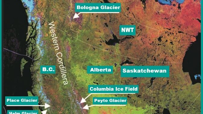
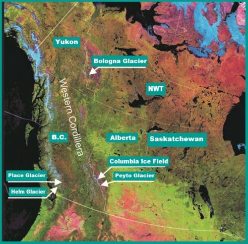
The National Glaciology Project is an ongoing research project overseen by Natural Resources Canada which is tracking changes in Canadian glaciers. The National Glaciology Project is designed to provide up to date information useful for decision makers. This is crucial as glaciers provide a significant amount of freshwater, the loss of which could have serious impacts on water tables, agriculture and drinking water supplies. Some of the glaciers currently being studied through this project include Bologna Glacier in Northwest Territories, Peyto Glacier in Banff National Park and Helm Glacier in British Columbia.

Provincial and Territorial Water Initiatives
It’s not only the federal government that is responsible for managing water and its impacts on communities, provincial and territorial governments have their own responsibilities. In Saskatchewan, the provincial Water Security Agency has received $140 million in funding for use in operation and capital upgrades for the province’s dams, and other water management and irrigation infrastructure. One significant beneficiary of this funding is the Lake Diefenbaker Irrigation Project, which will eventually cover 100 000 acres of land.

The Province of Ontario has launched the Housing-Enabled Water Systems Fund which provides funding to municipalities to develop, repair and expand drinking water, wastewater and stormwater infrastructure in the province. There were two periods of funding for this program, with 77 projects receiving approximately $1.3 billion.
The Government of Northwest Territories released its Ice Jam Flood Mapping Guidelines. With the assistance of funding from FHIMP, the Government of Northwest Territories created a set of best practices for developing flood maps in areas where flooding is driven by ice jams. These guidelines are meant to be utilized by government official, researchers, emergency responders and members of flood vulnerable communities for help in flood planning. While the guidelines were created specifically for the Northwest Territories, they are general enough to be useful for other communities that must plan for ice jam flooding.
Securing the Water Future
We Canadians are fortunate to live in a country with abundant freshwater. However, the rising droughts in the U.S. and other parts of the world should serve as a reminder not to take this resource for granted. As of March 25, 2025, 37.43% of the U.S. and Puerto Rico and 44.68% of the lower 48 states are in drought, according to the U.S. Drought Monitor. Globally, 2 billion people currently live in water-scarce regions, and two-thirds of the world’s population were projected to face water shortages. These alarming trends highlight the increasing vulnerability of freshwater resources, and serve as a stark reminder that access to clean water is not a given. It is shaped by geographic fortune, natural stewardship, infrastructure development, and sound political and governance choices.
In Canada, there are still 33 communities that live under long-term water boil advisories. It is important to consider that while various levels of government have effectively provided and protected communities from water, there is still work to be done.


Be the first to comment