
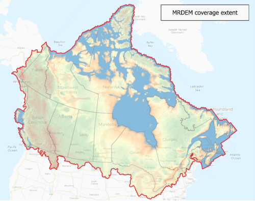
A New Digital Elevation Model
Natural Resources Canada introduced the Medium Resolution Digital Elevation Model (MRDEM), an update to the Canadian Digital Elevation Model (CDEM). The MRDEM, which includes a digital surface model and a digital terrain model, was created in line with Natural Resources Canada’s National Elevation Data Strategy and is a part of the CanElevation Series. The MDREM has a 30m spatial resolution and was created with data from the Copernicus Digital Elevation Model and high resolution LiDAR data when available. The MDREM was created to be useful in cross border elevation analysis.
Support for Flood Mapping
As a part of Canada’s climate change focused National Adaption Strategy, Natural Resources Canada has been administering the Flood Hazard Identification and Mapping Program (FHIMP). The FHIMP provides funding for provincial and territorial governments to help high risk communities prepare for flooding by developing flood mapping capacity. This program continued into 2024, with governments such as Saskatchewan and Yukon benefitting from available funding. Already, the Government of Yukon has created the first set in a series of 14 maps, covering a significant amount of river shoreline.

Helping to Support the Application of Satellite Data
In 2023, the Canadian Space Agency (CSA) set aside $5 million in funding to support the development of satellite data application within Canadian post-secondary institutions. This funding, which was designated for work beginning in early 2024, was awarded to 17 projects at 13 separate educational institutions. These projects vary in scope, with CSA supporting research in topics ranging from human health and the environment to national security. One of the projects to receive funding is work being completed by a team of researchers from the University of Saskatchewan. Led by Dr. Xulin Gao, this team is mapping the spread of woody plants in grassland ecosystems, with the goal of protecting the ecosystem while also quantifying the benefits of preservation.
The Indigenous Guardians Program
The Government of Canada is responsible for overseeing the Indigenous Guardians program, which provides funding to First Nation governments and organizations with the goal of helping communities exercise meaningful control and stewardship of their territories. This funding allows communities to protect their natural environment, economy and culture as they see fit. One application through this is accomplished is through mapping project – which is exactly what happened during the 2024- 2025 funding period. Several of the First Nations that have received grants in this period are using the funding towards mapping their territory and developing geospatial knowledge and capacity in their communities.
Provincial Governments are Mapping Too!
In Canada, it isn’t only the federal government that is leading environmental mapping initiatives, provincial governments are taking their own steps to understand their landscapes and react to the impacts of extreme weather in their communities. In Nova Scotia, the provincial government has recently released a Coastal Hazard Map, which highlights predicted high tide levels and storm surge affected areas in 2100. This map is designed to inform property owners about future risks to their properties, as well as potential home buyers and builders.

In British Columbia, the BC Energy Regulator recently released the new All Hazard Map, which serves as a replacement for their previous Fire Map. The new All Hazard Map maps important energy infrastructure alongside environmental hazards such as fires and flooding.

In Alberta, the Alberta Geological Survey, in cooperation withe the Alberta Energy Regulator, completed a multi-year project to create high quality aeromagnetic and gravity data throughout the Province. At the time of collection, this data collection was amongst one of the largest of these types of surveys in the world.

In Ontario, Geospatial Ontario has been steadily releasing high quality raster images from populated areas of the province. In 2024, Geospatial Ontario finished mapping eastern Ontario, with the raster data expected to be available in the early months of 2025.


Be the first to comment