• facebook
  • Twitter
  • Linkedin
  • Youtube
  • Linkedin Group
  • Post a Job
  • Post an Ad
  • Post an Event
  • Post a Directory Listing
  • Post a Press Release
  • Media Kit
  • My Account
  • Login
GoGeomatics
  • MAGAZINE
    • BIM & GIS
    • Community
    • Conference news
    • Earth Observation
    • Education & Careers
    • GEOAI
    • Announcements
    • Reality Capture & Lidar
    • Science
    • Technology
  • Directories
    • ASSOCIATION
    • INDUSTRY
    • EDUCATION
    • Open Data
  • EVENTS
    • GeoIgnite Events
    • Events Calendar
    • GoGeomatics Meetups
  • Services
    • Advertising
    • Marketing
    • Post a Job
    • Post an Ad
    • Post an Event
    • Post a Press Release
    • Post a Directory Listing
    • Media Kit
    • Web Design
  • Find a Job
  • Volunteer
    • Start a GoGeomatics Group
    • Editors & Writers Group
  • About Us
    • About Us
    • Contact Us
    • Frequently Asked Questions
  • Videos
HomeArcGIS

ArcGIS

Technology

The Power of Integrating Esri Tools with Leading SaaS Environments

12 December 2023 Farzaneh Farshad | ArcGIS

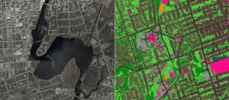
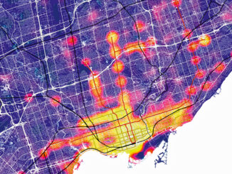
In the dynamic landscape of technology, the integration of robust tools becomes a pivotal factor in driving innovation and efficiency across various industries. One noteworthy development is the strategic collaboration between Esri, a global leader […]

Technology

International Geospatial Digest December 4th, 2023

4 December 2023 Volunteer Editors and Group Writers | ArcGIS

ArcGIS GeoBIM proves critical for Peruvian megaprojects Taylor Geospatial Institute increases hiring Growing the Australian geospatial industry Mapping USA’s food sources Jharkhand’s tribal development digital atlas ESRI’s new integrations ArcGIS GeoBIM proves critical for Peruvian […]

Technology

Canadian Geospatial Digest June 26th, 2023

26 June 2023 Volunteer Editors and Group Writers | ArcGIS

Making investments in energy-modelling tools to bolster efforts in reducing emissions “Open Urban Forests” The First National View of Urban Forestry Geospatial Data in Canada Hazardous fuel map to predict wildfires Canadian Wetland Inventory Achieving […]

Technology

Canadian Geospatial Digest June 12th, 2023

12 June 2023 Volunteer Editors and Group Writers | air quality

Canadian wildfires, Smoke map, hotspot map, fire intensity, and more An immense underwater mountain off the coast of British Columbia Modernizing Workflows with Mobile Technology and GIS On the Map with Jennifer Rasp Canada’s Leadership […]

Technology

International Geospatial Digest May 22nd, 2023

22 May 2023 Volunteer Editors and Group Writers | ArcGIS

Google Geospatial Creator: Turning the world into AR stage. IBM’s new Geospatial foundation model could help monitor the earth’s climatic change. Tackling deforestation via geospatial AI. Can water conflicts be settled using satellites? Unpiloted aerial […]

Kelowna group leader profile|
Community

Learning and Growing in Kelowna: Kelowna GoGeomatics Group Leader Profile

13 March 2023 GoGeomatics Canada | ArcGIS

GoGeomatics free group networking events are open to everyone from all areas of geomatics, including business owners, professionals, students, and others. The purpose of the Socials is to build a thriving geospatial community through networking […]

||||
Technology

Canadian Geospatial Briefing November 22nd, 2022

21 November 2022 GoGeomatics Canada | 2021 B.C Wildfire

AI aims to prevent a repeat of 2004 Peterborough flood City of Medicine Hat Wins 2022 ESRI special achievement in GIS award TCS, UofT team up with plan to create ‘urban data sets’ for smart […]

||||||
Technology

Accuracy and Precision [Part II]: Identify GIS Data Inconsistency: Examples From Toronto’s Open Data Portal

10 November 2021 Leo Poon | ArcGIS

This article is the second part of the accuracy and precision series, which discusses data characteristics, examples of data inconsistency and quality assurance guidelines. The previous article covered common errors often found during fieldwork. Managing […]

Posts pagination

« 1 2 3 … 17 »

Events

Notice
There are no upcoming events.

View All Events

Services

  • Post a Job
  • Post an Ad
  • Post an Event
  • Post a Directory Listing
  • Post a Press Release
  • Media Kit
  • My Account
  • Login

Jobs

Post a Job
  • Canada Maps and Poster Gallery Volunteer Leads — GeoIgnite 2026
    remote
  • GIS & Data Analytics Lead
    Beaumont, AB
  • Lead Surveyor, Projects/Arpenteur-géomètre principal, projets; arpenteuse-géomètre principale, projets
    North Bay, Thunder Bay
  • Senior GIS Developer
    Calgary, AB
View All Jobs
  • Directories
    • Associations Directory
    • Industry Directory
    • Education Programs
    • Open Data
  • Volunteer
    • Start a GoGeomatics Group
    • Editors & Writers Group
  • About Us
    • GoGeomatics Media Kit
    • Who We Are
    • Contact Us
    • FAQ’s
    • Advertising
    • Marketing
  • Subscribe
GoGeomatics
GoGeomatics is the largest and most popular communications hub promoting the Canadian geospatial community. The business was incorporated in 2011. GoGeomatics hosts over 100 fun, free, location technology networking events each year in cities across Canada.

© 2025 GoGeomatics

  • facebook
  • Twitter
  • Linkedin
  • Youtube
  • Linkedin Group