• facebook
  • Twitter
  • Linkedin
  • Youtube
  • Linkedin Group
  • Post a Job
  • Post an Ad
  • Post an Event
  • Post a Directory Listing
  • Post a Press Release
  • Media Kit
  • My Account
  • Login
GoGeomatics
  • MAGAZINE
    • BIM & GIS
    • Community
    • Conference news
    • Earth Observation
    • Education & Careers
    • GEOAI
    • Announcements
    • Reality Capture & Lidar
    • Science
    • Technology
  • Directories
    • ASSOCIATION
    • INDUSTRY
    • EDUCATION
    • Open Data
  • EVENTS
    • GeoIgnite Events
    • Events Calendar
    • GoGeomatics Meetups
  • Services
    • Advertising
    • Marketing
    • Post a Job
    • Post an Ad
    • Post an Event
    • Post a Press Release
    • Post a Directory Listing
    • Media Kit
    • Web Design
  • Find a Job
  • Volunteer
    • Start a GoGeomatics Group
    • Editors & Writers Group
  • About Us
    • About Us
    • Contact Us
    • Frequently Asked Questions
  • Videos
HomeBritish Columbia

British Columbia

|||||||||
Technology

QGIS & WorldClim: Using Zonal Statistics to Map Temperature Patterns

31 October 2016 GIS Program Langara CS | Alaska

There has never been a time in the history of GIS when so much free, high quality data has been available. As an example, the WorldClim site (http://www.worldclim.org/) offers temperature raster data, on a global […]

||||
Education & Careers

Canadian Surveyors “Remark” on History with Elk Pass Boundary Restoration Survey

17 October 2016 Association of British Columbia Land Surveyors | 2012

The Alberta-British Columbia Boundary Commission has just completed a monument restoration survey to restore a number of deteriorated provincial boundary monuments in the Elk Pass area of the Rocky Mountains. The work was undertaken by […]

||||
Community

The Importance of Students & Young Professionals in Canada’s Geomatics Community

12 September 2016 GoGeomatics Canada | advice

With the help of our sponsors GoGeomatics Canada is bringing students and young geospatial professionals together at 11 events from coast to coast (Complete list dates & locations is here).  Our September Back to School […]

|
Newsmakers & Press Releases
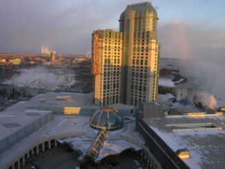
URISA Heads to Toronto for GIS-Pro 2016

9 September 2016 GoGeomatics Newsmakers | 2016

The Urban and Regional Information Systems Association (URISA), in partnership with its Ontario, Alberta and British Columbia Chapters, is pleased to share the details of GIS-Pro 2016: URISA’s 54th Annual Conference. The event will take […]

|GIS Ambassador Program|GIS Schools Canada|
Education & Careers

Canadian GIS Ambassador Program: Interview with Brent Hall, Director of Education & Research at Esri Canada

8 August 2016 GoGeomatics Canada | 2015

Interview with Brent Hall, Director of Education and Research at Esri Canada and, along with his staff, the initiator of Esri Canada’s GIS Ambassador program. Dr. Brent Hall is director of Education and Research at […]

No Picture
Community

Geoscience BC Launches Largest Airborne Magnetic Survey in its History

2 August 2016 GoGeomatics Newsmakers | 2013

Vancouver, BC — Geoscience BC announced the launch of its largest airborne magnetic survey to date — the Search Phase II survey which will produce high-resolution maps used to identify hidden mineral potential in west-central […]

|||Cluster Map of Spatial Autocorrelation
Community

University of Victoria Hosts Advanced Spatial Analysis Course

20 July 2016 Anders Erickson | 2016

Is neighbourhood socioeconomic status associated with pediatric and childhood injuries? Are such injuries clustered in space? How can I model the spatial dependence in pediatric and childhood injuries in order to help policy makers develop […]

No Picture
Technology

Making a Crow Attack Web Page With Open Source GIS Tools

6 July 2016 GIS Program Langara CS | 2016

Of all the pleasant events that happen in spring, crow attacks rank at the bottom of the pile. Crows become aggressive as the fledgling crows hatch, and attack anything that passes near the nest – […]

Posts pagination

« 1 … 7 8 9 … 17 »

Events

Notice
There are no upcoming events.

View All Events

Services

  • Post a Job
  • Post an Ad
  • Post an Event
  • Post a Directory Listing
  • Post a Press Release
  • Media Kit
  • My Account
  • Login

Jobs

Post a Job
  • Canada Maps and Poster Gallery Volunteer Leads — GeoIgnite 2026
    remote
  • GIS & Data Analytics Lead
    Beaumont, AB
  • Lead Surveyor, Projects/Arpenteur-géomètre principal, projets; arpenteuse-géomètre principale, projets
    North Bay, Thunder Bay
  • Senior GIS Developer
    Calgary, AB
View All Jobs
  • Directories
    • Associations Directory
    • Industry Directory
    • Education Programs
    • Open Data
  • Volunteer
    • Start a GoGeomatics Group
    • Editors & Writers Group
  • About Us
    • GoGeomatics Media Kit
    • Who We Are
    • Contact Us
    • FAQ’s
    • Advertising
    • Marketing
  • Subscribe
GoGeomatics
GoGeomatics is the largest and most popular communications hub promoting the Canadian geospatial community. The business was incorporated in 2011. GoGeomatics hosts over 100 fun, free, location technology networking events each year in cities across Canada.

© 2025 GoGeomatics

  • facebook
  • Twitter
  • Linkedin
  • Youtube
  • Linkedin Group