Europe

Ottawa April 29th: Geospatial Career & Job Hunting Seminar

Saturday: April 29th – 9:15 AM Ottawa Library, Main Branch  Basement Conference Room 120 Metcalfe, Ottawa, Ontario We will be…

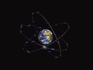
New Galileo navigation system is experiencing clock failures

  Since December 15, 2016, the new Galileo global satellite navigation system has been up and running. Unfortunately, there are…

The 5 most interesting things that happened in geomatics in 2016

Let’s take a step back and have a look at what happened this year. To be honest, it was pretty…

Predicting the Future of the GIS in Canada

Editors note: This article has been jointly written by Bruce McCormack and Gordon Plunkett. Bios can be found at the…

Literary Peregrinations: Geographers as Explorers

While I was reading Andrea Wulf’s “The Invention of Nature. Alexander von Humboldt’s New World”. I noted a comment on…

Canadian Cartography: GoGeomatics Edmonton Visits the University of Alberta Map Library & Collections

Last night the Edmonton GoGeomatics Group had the chance to explore the amazing collection of historic maps at the University…

Canada Takes Part: Arctic Spatial Data Infrastructure Meets in Anchorage

The Arctic SDI Board, which includes mapping executives from Canada, Kingdom of Denmark, Finland, Iceland, Norway, Russia, Sweden and the…

EMSA expands use of RADARSAT-2 information for maritime applications

MacDonald, Dettwiler and Associates Ltd. a global communications and information company announced that it has signed a four year contract…

Conversations with Michael Goodchild on Questions of Geography

Recently, I had the opportunity to sit down with Michael Goodchild and talk about his book and Geography.  Michael was…

Postal Codes: Canada Post Backs Down on Crowdsourced Open Data

Have you ever felt the wrath of a Canadian Crown Corporation? In 2011 Canada Post set its sights on Ervin…

Northern Canada: Nunavut and a New View of Community Mapping

The writer and his wife, Heather Stewart visited grandchildren in Iqaluit for three weeks in April During the first week…

JMap provides instant access to all of the Canadian railway network’s geospatial data

K2 Geospatial, a leading geospatial software company and the editor of JMap, is pleased to announce the creation of the…