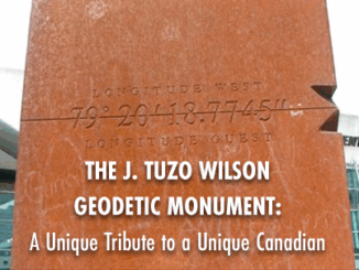
GPS
Progress in Addressing GPS/GNSS Vulnerabilities
An overreliance on GPS/GNSS for positioning, navigation and timing applications underscores key vulnerabilities. Defense, security, safety, commerce, and critical infrastructure…
Responding to Wildfires and Emergencies: Increasing Situational Awareness with Avenza Maps and Geospatial Data
In Canada, an estimated 3,600 wildfires burned approximately 581,004 acres in 2020 alone.1 Similarly, in the United States, an estimated…
The top 6 Satellite Remote Sensing Software tools
Nowadays, satellite remote sensing comes in handy and can now be employed in our day-to-day activities. This technology, with the…
Global Positioning System (GPS): How does it Work?
I recently read about the delay of China’s BeiDou mission and how, instead, China chose to launch a fifth satellite…
Why are they wearing those GPS vests during a football game? — GI-technology in modern-day soccer
Geographic information technology has been used to answer questions of locations. Where are the sewer lines? How close is the…
Your Canadian Geospatial Briefing for Sept 22: First woman to head CSA; Polar Bears’ GPS Collars Reveal Hidden Histories; Data Crisis in Covid-19; What Would The Impact of the Beirut Explosion Look Like on Maps of Canadian Cities; Should You Get a GIS Certification?
Lisa Campbell becomes the first woman to head the Canadian Space Agency – CBC The Government of Canada announced earlier…
Your International Geospatial Briefing for August 31st: Trimble and Totalmobile Awarded HS2; Everest survey succeeds; Underwater heat blob growing in the Arctic; China Launches Beidou; Amazonian Tribe Applies Location Intelligence
Trimble and Totalmobile Awarded HS2 Contract from Civil Engineering Contractor EKFB Trimble and Totalmobile have developed the first cloud-based vehicle…
Low-cost, less-time, lesser-logistics and high-accuracy mapping with drone-imagery
Highlights There is a tendency to use aerial photographs and digital images as the cartographic product!These pictures are the primary…
Your Canadian Geospatial Briefing for June 29th: New tech against wildfires; Bathymetric Lidar mapping; COVID-19 effect Heat maps; Eastern Canada DOT Power Platform; Tim Kopra as Vice President, Robotics and Space Operations of MDA
Scientists armed with new tech and cool gadgets face off against wildfires More extreme weather each spring makes wildfires a…
Your Canadian Geospatial Briefing for June 15th: Canadian Drone delivery solution; City of Montreal open data; Tagged leatherback sea turtles; Endangered Fish in BC
Drone company will convey COVID-19 medical equipment to First Nation Drone Delivery Canada (DDC) will transport COVID-19 medical products using…
Your International Geospatial Briefing for August 26th: Russia, China Alliance on Navigation Satellites Threatens GPS; Three New Programs Are Added to Hexagon Geospatial Education; The Shift from 4G to 5G Will Change Just About Everything; Elon Musk: “Anyone relying on lidar is doomed,” Experts: Maybe not; Monitoring Wildfire Risk Using Space and AI
Russia, China Alliance on Navigation Satellites Threatens GPS Russian and Chinese satellite navigation systems have recently stated that their main…
Careers In Land Surveying
Land surveying is an exciting Geomatics Career Field that is in high demand and often over looked by many young people…