
Education & Careers
My COGS GIS Education, Part II
In my first article, I introduced the how and why I chose to attend COGS from the fall of 2014 to spring 2016. In Part 2, I wanted to give some insight into the first-year […]
In my first article, I introduced the how and why I chose to attend COGS from the fall of 2014 to spring 2016. In Part 2, I wanted to give some insight into the first-year […]
COINAtlantic would like to extend an invitation on behalf of the Global Spatial Data Infrastructure (ASDI) Association to participate in their webinar on Coastal and Marine SDI Best Practices—March 29th at 2PM CEST. GSDI Coastal/Marine […]

Awareness for climate change has been steadily increasing ever since the Green Revolution in the 1960s. There is a plethora of data, maps, and Geographic Information Systems (GIS) applications available freely or accessible to the […]
I often contemplate what it would have been like working at the same job for an entire career. Mind you, the thought of the same job day in and day out never appealed to me. I’m […]
Vous êtes peut-être un analyste, un professionnel ou un spécialiste au sein d’un département et qui utilise énormément la géomatique. Votre organisation est peut-être aussi de grande taille et détient de nombreux départements pour qui […]
Not many companies undertake the ambitious goal of creating a new geospatial software suite from scratch. Ecere, a Canadian company based in Gatineau, Québec has been developing a software platform that has positioned them to […]

You might be a Manager, Consultant, GIS Specialist, Geomatics Engineer, Survey Analyst, Cartographer, Spatial Analyst, GIS Developer or Remote Sensing Analyst. There are some non-technical skills that can make you rise above your peers. […]
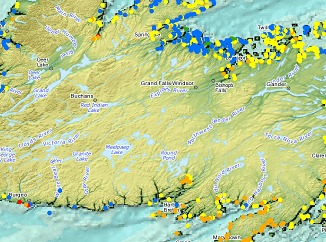
Fredericton, NB, Canada – November 01, 2016 – Teledyne CARIS™ is pleased to announce the release of HIPS and SIPS™ 10. This release introduces exciting new capabilities for automation, efficiency, and usability through the integration of […]