Lidar images

Emesent Achieves Survey-Grade with SLAM-base Mapping

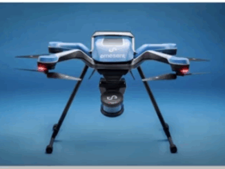
  Emesent recently launched its Hovermap ST to assist in the improvement of LiDAR mapping. On April 5, 2022, at…

LiDAR News Weighs in on HD Map Standards and the Creation of Opportunities

LiDAR 2022 held a live stream presentation on April 5, 2022, with LiDAR News CEO, Gene Roe. Roe spoke on…

TopoDOT Compares Data and Applications of UAV and LiDAR Point Cloud

On April 5, 2022, LiDAR COMEX 2022 held a live stream presentation on “data comparison and applications of UAV imagery-based…

Cansel Discusses Innovations in LiDAR: Latest Technologies Across Industries

On April 5, 2022, LiDAR COMEX 2022 held a live stream presentation by Cansel. The topic of “Scan to BIM…

Got a Drone – Now What? Mapping with your UAV

Got a Drone – Now What? Mapping with your UAV It was inevitable that the proliferation of drone technology would…