TopoDOT Compares Data and Applications of UAV and LiDAR Point Cloud

TopoDOT, Point Cloud Processing Software
On April 5, 2022, LiDAR COMEX 2022 held a live stream presentation on “data comparison and applications of UAV imagery-based point cloud and LiDAR-based point cloud for surveying and mapping. The speaker was Jennifer Triana, Business Development Director at TopoDOT.
TopoDOT is a microstation application for extracting high-quality models from point cloud. It takes data from whatever system is being used and will help manage, assess, and extract the data so it can be turned into a line work model.

Jennifer Triana, Business Development Director at TopoDOT.
The goal for UAV is the expansion of UAV applications, education about the many different data sets, applications, systems, and capabilities so people can pick the right tool for the job, and clear up confusion between LiDAR and Photogrammetry-based data sets.
UAV, or Unmanned Aerial Vehicle, is just a drone. UAS, or Unmanned Aerial System, is the drone vehicle, pilot, and sensor. It is the complete system and is interchangeable with UAVs for general purposes. A sample of UAV applications includes Real Estate photography, mapping and surveying, disaster zone mapping, bridge inspection, asset inspection, GIS data collection, agricultural uses, and vegetation encroachment among many others.
There are four main types of UAVs, multi-rotor drones (the cheapest option as it is the easiest to make), fixed-wing drones, single-rotor helicopters, and fixed-wing hybrid VTOLs. There are two types of sensors, camera photogrammetry (SFM or structure from motion), and LiDAR drone (LiDAR UAV or UAS).
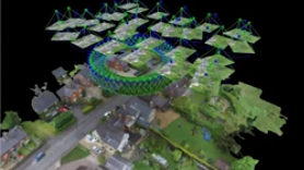
Photogrammetry collects high-resolution photos that overlap an area, creating various views of one feature. It is best used in large buildings or structures, where there are more relaxed accuracy requirements, and areas free of dense trees or forest canopies. LiDAR (light detection and ranging) uses time of light and pulses of laser light. The pulses are quick and done in different directions to determine the surface of objects or the ground. A sheet of light forms over the terrain and has geo-referencing. This system needs additional equipment such as GNSS, GPS, INS-IMU, and cameras. LiDAR should be used over Photogrammetry when there are heavy canopies, utilities, powerlines, or fusing with MLS or TLS.
Both systems produce good and bad data sets, so pick the right tool for the job.
You can watch the whole presentation, as well as Q and A on YouTube below.


