
Community
Ground Truthing
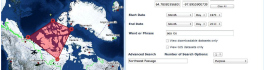
In the world of Remote Sensing, one of the key concepts is ground truthing. This has both a positional component, as well as a field verification of the land cover. These complementary activities are important […]
In the world of Remote Sensing, one of the key concepts is ground truthing. This has both a positional component, as well as a field verification of the land cover. These complementary activities are important […]

Mapping UAV’s new designation will help operators to boost their businesses Swiss professional drone manufacturer, senseFly, today announced that its eBee has become the first fixed-wing system to be designated a ‘compliant small UAV’ by […]

As those of you who have tried their hand at OpenStreetMapping know, OSM can quickly turn from a hobby into a full-blown obsession! OpenStreetMap is a free, editable, open access map created by volunteers all […]
BlackBridge, a leading provider of satellite imagery and geospatial solutions, announced today that it has entered into a definitive agreement for Planet Labs to acquire the RapidEye suite of core offerings. Planet Labs is a […]
The growing interest in providing open data access has long been integrated into the field of Geomatics. However, the use of Geomatics within open data portals is relatively uncommon. This inclusion provides an interactive and […]
Richmond, BC – MacDonald, Dettwiler and Associates Ltd. (“MDA” or the “Company”) (TSX: MDA), a global communications and information company, announced that it has been awarded three contracts with the Malaysian Remote Sensing Agency (MRSA), […]
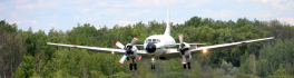
June 23rd marked a special day in the history of aviation and space in Canada. A very special aircraft, a Convair-580, with its advanced Synthetic Aperture Radar (SAR) sensors, made its final flight after setting […]
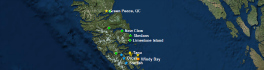
In my previous blog “Storytelling: Haida Gwaii,” I referenced the Geomatics Association of Nova Scotia’s (GANS) mentoring program between myself and Melissa Ristow, COGS graduate 2015. Together, our idea was to explore the Story Mapping […]