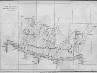
A History of Everest Mapping
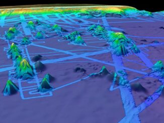
As awe inspiring as the mountain is, so are the maps. Mount Everest is often considered “a symbol of something impossible”. For mountaineers standing atop Everest, near the Nepal-China border on the huge ice block […]
Every day, Planet images the full Earth at 3.5m resolution and anywhere sub-daily at <50cm. This data is critical in working to make global change visible, accessible, and actionable in regards to climate change. On […]
Ground Temperatures Hit 118 Degrees in the Arctic Circle During the recent heatwave in Siberia ground temperatures reached 118 degrees Fahrenheit (48 degrees Celsius) as seen by satellite imagery. The Copernicus Sentinel satellites were able […]
3D mapping is continuing to advance and be crucial to our understanding of the planet we live on and how we study it. Maxar, a titan in the EO industry, is building what may be […]
GoGeomatics Community manager Tanya Tejassvi, had an interesting and insightful conversation with Dave McIlhagga – President of International Map Industry Association. Through the chat, we got to know more about IMIA, as well as Dave’s […]
How would like to support, or even participate in what could become the most ambitious 3D surveying and mapping project ever? It could be the opportunity of a lifetime. A unique, global initiative is leveraging […]
On June 21, 2019, the Accessible Canada Act (ACA) received Royal Assent, making it law in Canada. The Accessible Canada Act is federal accessibility legislation. Its stated purpose is to achieve a barrier free Canada by 2040. The Act […]
The State of the Map Industry is a new virtual event IMIA has developed for you to hear directly from leading experts in the geospatial, mapping and location fields of our industry. Our invited panel […]