
Community
My Bookcase: The Geography of Canada
It’s been three years since I wrote up my top ten list geography books in a post called 50 Years a Geographer: My Top Ten books about Geography. This list is a follow up to […]
It’s been three years since I wrote up my top ten list geography books in a post called 50 Years a Geographer: My Top Ten books about Geography. This list is a follow up to […]
GeoIgnite 2019 has a new platinum sponsor! Mapbox joins leaders from technology, government and academia in discussing the current and future state of Canada’s location tech sector in Ottawa this June. With much of the […]
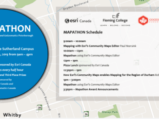
GoGeomatics Peterborough and Esri Canada are hosting a Mapathon at Fleming College to create data for the Region of Durham using Esri’s Community Maps Editor on Saturday, May 11, 2019 from 9am – 4pm. The […]
Bert de Bruijn is an Ottawa IT security consultant and founder of the WikiWar Project. Bert is passionate about Crowdsourcing and Geovisualizing War History. A former member of the Canadian armed forces he’s been a […]
The Canadian Cartographic Association (CCA) was founded in 1975 with the aim to promote interest in maps and cartographic materials, deepen the understanding and knowledge of maps by encouraging research in the field of cartography, advance […]
I recently returned to Hamilton after five years of teaching at a Washington DC university, taking a paid partial-sabbatical at the end of my contract. Unfortunately the time off gave me too much opportunity to […]
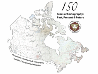
The 42nd Annual Conference of the Canadian Cartographic Association was held, May 31st thru June 2nd, at Carleton University. Inspired by the 150th birthday of Canada, the guiding theme of this year’s conference was “150 […]
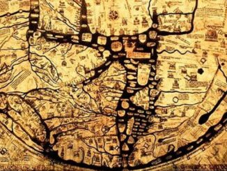
As much a science as an art; cartography makes one wonder how the artist or mathematician-cum-geographer captured the most finite of cartographic details. Ancient maps are fascinating and inspiring. In this article I will discuss […]