user
RAC launches online Canadian Rail Atlas
One hundred and fifty years after Confederation launched the idea of a railway that would unite the country, the Railway…
New Galileo navigation system is experiencing clock failures
Since December 15, 2016, the new Galileo global satellite navigation system has been up and running. Unfortunately, there are…
Software Development – The Key to Ecere’s Success
It is rare to learn of a GIS company in which much R&D is done up front to create the…
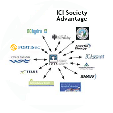
The Integrated Cadastral Information (ICI) Society and ParcelMap BC
This is the first of two articles on the release of ParcelMap BC Data, which we see as a significant…
Graph Databases – Recent development in Neo4j may help accommodate the Geospatial Community
Graph Databases and GIS & Technology (GIS&T) In the era of big data, graph databases are becoming very popular as…
Marine Geomatics Primer: Using UUVs to Take Flight Underwater
Unmanned Underwater Vehicles One of the most interesting things to happen in regards to marine geomatics technology has been the…
The Future of GIS Software? QGIS A Popular Open-Source GIS for the Masses
In today’s geomatics society, ArcGIS, developed by Esri, is a giant and dominates the GIS software market. However, there are…
Canadian Geomatics Innovation: Ecere Develops a Next Generation GIS
Not many companies undertake the ambitious goal of creating a new geospatial software suite from scratch. Ecere, a Canadian company…
Interview with Ted Mackinnon: Promoting Canadian GIS & Geomatics on Twitter
GoGeomatics has been actively using Twitter to reach out to the geospatial community since 2009. We have written and hosted…
List of Canadian Geomatics Conferences and Events for 2017
This is our list Canadian geomatics conferences and events for 2017. Here you will find events pertaining to GIS, remote…
A List of Geospatial Open Data Resources in Canada
Recently, I read an article about the Canadian Geospatial Data Infrastructure (CGDI) that seeks to explain why the CGDI, among many…
Planning an Enterprise GIS from the Bottom Up
You might be an observant professional in a department that uses GIS. Your organization may be large and have many…


